I found this animation on Wikipedia, showing the difference between true (geographical) north and the direction a compass points (calle the magnetic declination or variation):
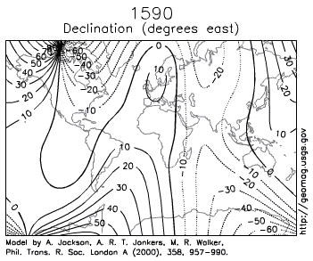
That's saying that at a line marked "10", magnetic north is 10 degrees east of true north. If you watch one place, eg the Caribbean, you can see it goes from about -5 to +10 in the 400 years shown. New York is pretty stable, between -10 and -15. London has changed a lot more - from +10 in 1590, to about -25 in 1830, and then down to -5 in 1990. It's a complex pattern.
Columbus didn't have any map for where he was going, so it didn't really matter that much to him; as long as the declination was relatively stable in each place in that year, a compass would still have done its job, ie saying where north is when the sky is cloudy. Every time you get a clear night, you can check the declination just by checking the compass against the pole star (or a clear day, if you check where the sun is when it's at its highest).

 = new reply since forum marked as read