| Latest | Greatest | Lobby | Journals | Search | Options | Help | Login |
|
|
|
This topic is archived. |
| Home » Discuss » Archives » General Discussion: Presidential (Through Nov 2009) |
|
| FightingIrish
|
Wed Sep-10-08 11:20 PM Original message |
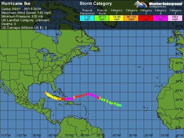
| This is about to arrive in Texas |
| Printer Friendly | Permalink | | Top |
| valerief
|
Wed Sep-10-08 11:22 PM Response to Original message |
| 1. Wow!!! It's huge. |
| Printer Friendly | Permalink | | Top |
| CoffeeCat
|
Wed Sep-10-08 11:22 PM Response to Original message |
| 2. It it a cat 3 right now? |
| Printer Friendly | Permalink | | Top |
| Lisa0825
|
Wed Sep-10-08 11:32 PM Response to Reply #2 |
| 5. 2, expected to be a 3. |
| Printer Friendly | Permalink | | Top |
| CoffeeCat
|
Wed Sep-10-08 11:40 PM Response to Reply #5 |
| 6. CNN story says maybe a Cat 4.... |
| Printer Friendly | Permalink | | Top |
| Lisa0825
|
Wed Sep-10-08 11:47 PM Response to Reply #6 |
| 8. National Hurricane Center forecasts do not say a 4 at this point, |
| Printer Friendly | Permalink | | Top |
| 1corona4u
|
Thu Sep-11-08 12:11 AM Response to Reply #8 |
| 14. Honestly, I think it's going to turn more in a southerly direction... |
| Printer Friendly | Permalink | | Top |
| WolverineDG
|
Thu Sep-11-08 12:15 AM Response to Reply #14 |
| 17. Generally, storms that don't come through the strait |
| Printer Friendly | Permalink | | Top |
| 1corona4u
|
Thu Sep-11-08 12:33 AM Response to Reply #17 |
| 20. Really? Seems a few have... |
| Printer Friendly | Permalink | | Top |
| uppityperson
|
Fri Sep-12-08 09:54 AM Response to Reply #20 |
| 25. Well, other than all those... |
| Printer Friendly | Permalink | | Top |
| JDPriestly
|
Thu Sep-11-08 02:06 AM Response to Reply #14 |
| 23. It looks like it could hit Mexico rather than Texas. |
| Printer Friendly | Permalink | | Top |
| DangerousRhythm
|
Wed Sep-10-08 11:48 PM Response to Reply #5 |
| 9. I'm in SE Houston |
| Printer Friendly | Permalink | | Top |
| texanwitch
|
Thu Sep-11-08 12:42 AM Response to Reply #9 |
| 21. West Houston here. |
| Printer Friendly | Permalink | | Top |
| DangerousRhythm
|
Fri Sep-12-08 03:25 AM Response to Reply #21 |
| 24. Thanks, you too! |
| Printer Friendly | Permalink | | Top |
| Faryn Balyncd
|
Wed Sep-10-08 11:25 PM Response to Original message |
| 3. What the G.O.P. has turned into would make Ike vomit! |
| Printer Friendly | Permalink | | Top |
| wiseoldman
|
Wed Sep-10-08 11:29 PM Response to Original message |
| 4. Where is the Dynamic Duo.... the McSame Twins... |
| Printer Friendly | Permalink | | Top |
| 1corona4u
|
Wed Sep-10-08 11:46 PM Response to Original message |
| 7. We're still getting the winds from this.... |
| Printer Friendly | Permalink | | Top |
| mb7588a
|
Wed Sep-10-08 11:48 PM Response to Original message |
| 10. It's gonna be a cat. 4 if not a 5. |
| Printer Friendly | Permalink | | Top |
| Lisa0825
|
Wed Sep-10-08 11:53 PM Response to Reply #10 |
| 11. I've been following wunderground, and it predicts a cat 3 at landfall so far. |
| Printer Friendly | Permalink | | Top |
| 1corona4u
|
Thu Sep-11-08 12:08 AM Response to Reply #11 |
| 13. Yeah, I think it goes in a 3. Maybe even a strong 2. |
| Printer Friendly | Permalink | | Top |
| Lisa0825
|
Thu Sep-11-08 12:13 AM Response to Reply #13 |
| 16. Thanks for that.... |
| Printer Friendly | Permalink | | Top |
| 1corona4u
|
Thu Sep-11-08 12:16 AM Response to Reply #16 |
| 18. I've been through many hurricanes... |
| Printer Friendly | Permalink | | Top |
| 1corona4u
|
Thu Sep-11-08 12:13 AM Response to Reply #10 |
| 15. No, it's not....don't scare everyone. |
| Printer Friendly | Permalink | | Top |
| blogslut
|
Wed Sep-10-08 11:55 PM Response to Original message |
| 12. Good wishes and love to my neighbors |
| Printer Friendly | Permalink | | Top |
| JFN1
|
Thu Sep-11-08 12:23 AM Response to Original message |
| 19. Rely on our fabulous MSM to keep things real... |
| Printer Friendly | Permalink | | Top |
| SheilaT
|
Thu Sep-11-08 12:45 AM Response to Original message |
| 22. Read Isaac's Storm |
| Printer Friendly | Permalink | | Top |
| DU
AdBot (1000+ posts) |
Sun May 05th 2024, 02:10 AM Response to Original message |
| Advertisements [?] |
| Top |
| Home » Discuss » Archives » General Discussion: Presidential (Through Nov 2009) |
|
Powered by DCForum+ Version 1.1 Copyright 1997-2002 DCScripts.com
Software has been extensively modified by the DU administrators
Important Notices: By participating on this discussion board, visitors agree to abide by the rules outlined on our Rules page. Messages posted on the Democratic Underground Discussion Forums are the opinions of the individuals who post them, and do not necessarily represent the opinions of Democratic Underground, LLC.
Home | Discussion Forums | Journals | Store | Donate
About DU | Contact Us | Privacy Policy
Got a message for Democratic Underground? Click here to send us a message.
© 2001 - 2011 Democratic Underground, LLC