General Discussion
Related: Editorials & Other Articles, Issue Forums, Alliance Forums, Region Forums39 Years Ago Today; Mount St Helens erupts, killing Harry Truman (and others)
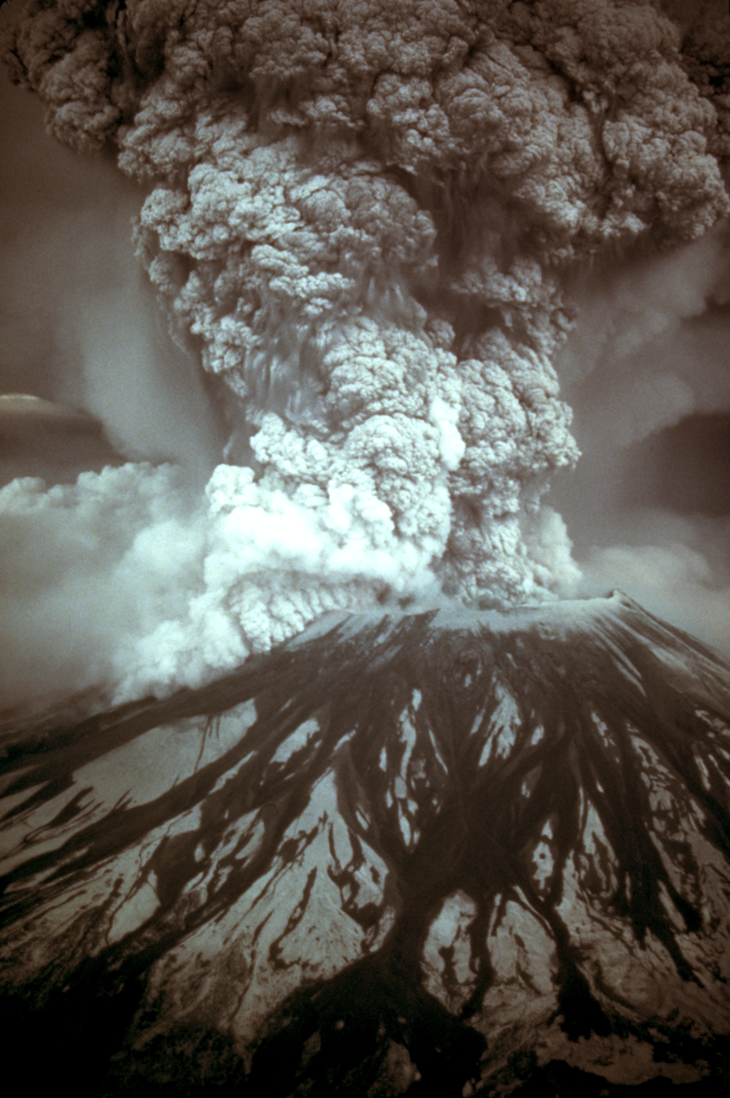
On May 18, 1980, a major volcanic eruption occurred at Mount St. Helens, a volcano located in Skamania County, in the U.S. state of Washington. The eruption (a VEI 5 event) was the most significant volcanic eruption to occur in the contiguous 48 U.S. states since the much smaller 1915 eruption of Lassen Peak in California. It has often been declared the most disastrous volcanic eruption in U.S. history. The eruption was preceded by a two-month series of earthquakes and steam-venting episodes, caused by an injection of magma at shallow depth below the volcano that created a large bulge and a fracture system on the mountain's north slope.
An earthquake at 8:32:17 a.m. PDT (UTC−7) on Sunday, May 18, 1980, caused the entire weakened north face to slide away, creating the largest landslide ever recorded. This allowed the partly molten, high-pressure gas- and steam-rich rock in the volcano to suddenly explode northwards toward Spirit Lake in a hot mix of lava and pulverized older rock, overtaking the avalanching face.
An eruption column rose 80,000 feet (24 km; 15 mi) into the atmosphere and deposited ash in 11 U.S. states and significant ash in two Canadian provinces. At the same time, snow, ice and several entire glaciers on the volcano melted, forming a series of large lahars (volcanic mudslides) that reached as far as the Columbia River, nearly 50 miles (80 km) to the southwest. Less severe outbursts continued into the next day, only to be followed by other large, but not as destructive, eruptions later that year. Thermal energy released during the eruption was equal to 26 megatons.
Approximately 57 people were killed directly, including innkeeper Harry R. Truman, photographers Reid Blackburn and Robert Landsburg, and geologist David A. Johnston. Hundreds of square miles were reduced to wasteland, causing over $1 billion in damage (equivalent to $3.3 billion today), thousands of animals were killed, and Mount St. Helens was left with a crater on its north side. At the time of the eruption, the summit of the volcano was owned by the Burlington Northern Railroad, but afterward the land passed to the United States Forest Service. The area was later preserved, as it was, in the Mount St. Helens National Volcanic Monument.
<snip>
As May 18 dawned, Mount St. Helens' activity did not show any change from the pattern of the preceding month. The rate of bulge movement, sulfur dioxide emission, and ground temperature readings did not reveal any changes indicating a catastrophic eruption. USGS volcanologist David A. Johnston was on duty at an observation post approximately six miles (10 km) north of the volcano: as of 6:00 a.m., Johnston's measurements did not indicate any unusual activity.
At 8:32 a.m., a magnitude 5.1 earthquake centered directly below the north slope triggered that part of the volcano to slide, approximately 7–20 seconds after the shock. The landslide, the largest in recorded history, travelled at 110 to 155 miles per hour (177 to 249 km/h) and moved across Spirit Lake's west arm. Part of it hit a 1,150-foot-high (350 m) ridge about six miles (10 km) north. Some of the slide spilled over the ridge, but most of it moved 13 miles (21 km) down the North Fork Toutle River, filling its valley up to 600 feet (180 m) deep with avalanche debris. An area of about 24 square miles (62 km2) was covered, and the total volume of the deposit was about 0.7 cubic miles (2.9 km3).
Scientists were able to reconstruct the motion of the landslide from a series of rapid photographs by Gary Rosenquist, who was camping 11 miles (18 km) away from the blast. Rosenquist, his party and his photographs survived because the blast was deflected by local topography one mile (1.6 km) short of his location.
Most of St. Helens' former north side became a rubble deposit 17 miles (27 km) long, averaging 150 feet (46 m) thick; the slide was thickest at one mile (1.6 km) below Spirit Lake and thinnest at its western margin. The landslide temporarily displaced the waters of Spirit lake to the ridge north of the lake, in a giant wave approximately 600 feet (180 m) high. This in turn created a 295 feet (90 m) avalanche of debris consisting of the returning waters and thousands of uprooted trees and stumps. Some of these remained intact with roots, but most had been sheared off at the stump seconds earlier by the blast of super-heated volcanic gas and ash that had immediately followed and overtook the initial landslide. The debris was transported along with the water as it returned to its basin, raising the surface level of Spirit Lake by about 200 ft (61 m).
More than three decades after the eruption, floating log mats persist on Spirit Lake and nearby St. Helens Lake, changing position with the wind. The rest of the trees, especially those that were not completely detached from their roots, were turned upright by their own weight and became waterlogged, sinking into the muddy sediments at the bottom where they have become petrified in the anaerobic and mineral-rich waters. This provides insight into other sites with a similar fossil record.
</snip>

 = new reply since forum marked as read
Highlight:
NoneDon't highlight anything
5 newestHighlight 5 most recent replies
= new reply since forum marked as read
Highlight:
NoneDon't highlight anything
5 newestHighlight 5 most recent replies

PunkinPi
(5,253 posts)He lived there at the time and saw it.

whistler162
(11,155 posts)in Spokane when it blew. Has a couple of jars of the ashes,

Takket
(23,560 posts)I grew up in Massachusetts but there was a girl in my class who had relatives near the eruption. One day for show and tell she handed out small bags of ash they had given her to everyone. This was years later maybe 1988ish? I loved my bag thought it was so cool. But lost it at some point. Don’t know what happened to it.

PunkinPi
(5,253 posts)I grew up in Maryland, and was almost 4 at the time of the eruption, so I thought it was pretty neat to have a little piece of history. I think I may have taken it to show and tell a time or two in elementary school. 
dalton99a
(92,856 posts)

malaise
(294,261 posts)and the other major event in our hemisphere that year was Hurricane Gilbert in September

mgardener
(2,312 posts)Was in labor with my son, he was born the next day!
I always remember Mt St. Helen !
It was the talk of the hospital floor on the 19th!

haele
(15,207 posts)He was a doctoral student when she was a secretary and ad hoc department photographer at the UW Geology department. They worked together on a supplimental textbook on the geology of the Pacific Northwest (Cascadia) back in the late-70s. He ended up being a friend of the family spent two years as an assistant coach for the youth soccer team Dad coached before he graduated and took a job at Menlo Park. He loved Godzilla movies and active volcanos.
And yeah, my sixteen year old self had a crush on him for about three months...
RIP Davy. You died doing what you loved.
Haele

Aristus
(71,897 posts)Didn't see or hear a thing, because the wind was blowing the other way. First I knew something was up was when a bunch of helicopters from Fort Lewis flew over our campground on the way to the mountain. Someone ran in from another campsite where they had a radio and announced: "Mount St. Helen just blew! Mount St. Helen just blew!"
mommymarine2003
(352 posts)We lived in Pullman, Washington, and my daughter was 12 days old when the volcano blew. My mother-in-law was down from Spokane to see our new baby, and we had plans to go to Moscow, Idaho for the Renaissance Fair. The horizon was black, and I was angry how wrong the weatherman was as he hadn't predicted any "rain". Several hours later it was raining ash and we were in darkness. It was surreal. We had no idea if we would wake up the next day to continued darkness. The whole community was shut down for days, which included the university. I worried about my new baby's lungs, and my mother-in-law was stuck with us for at least a week. We saved ash in baby food jars and mailed several jars to friends and family for souvenirs.
Now I live in the Portland, Oregon area, and we have views of Mt. St. Helens, Mt. Adams, and Mt. Hood from our house. Mt. St. Helens, with her flat top, still is beautiful. If any of these ever erupt again, we will have a front row seat! We have earthquake insurance, but I don't know if we have coverage for volcanoes. We also live on a butte, which I did not know until about two years ago, is actually an extinct cinder cone. My baby, of course, is all grown up with a family and lives in the evacuation zone of Mt. Rainier up in Washington. Her kids practice lahar drills at school. The Northwest is a beautiful but interesting place to live.

panader0
(25,816 posts)When I worked as a thinner in the woods near Mt. Hood, Oregon, I could
see Mt. St. Helens easily across the Columbia. This was a couple of years before it blew.
flying_wahini
(8,254 posts)The landslide of rock was going 110-125mph!!!!!
flying_wahini
(8,254 posts)This article left a lasting impression on me.
https://www.theatlantic.com/science/archive/2016/08/a-major-earthquake-in-the-pacific-northwest-just-got-more-likely/495407/

AllaN01Bear
(28,930 posts)i was young and living in glendora ca when that happened .