General Discussion
Related: Editorials & Other Articles, Issue Forums, Alliance Forums, Region ForumsHow Land Is Used Map
Last edited Sun May 17, 2020, 10:18 PM - Edit history (1)
This is an interesting map. It gives us a good idea as to how much land is used for what and how they all relate proportionally.
My goodness, the cows and their feed! There's the beef. America is made of meat. 
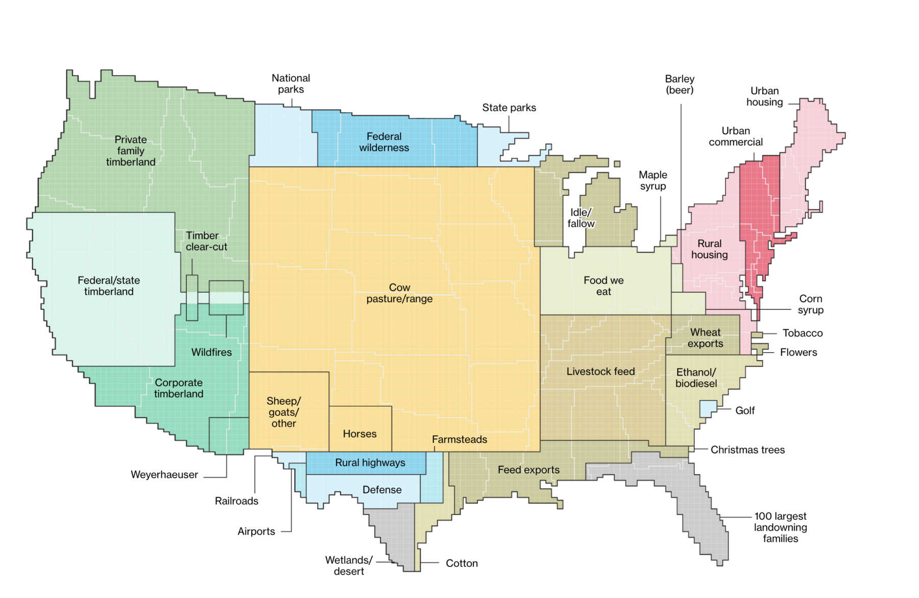
https://ritholtz.com/2018/07/heres-america-uses-land/
Edited to add: If you click through on the map at the site above, you will get several more maps with more detail and breakdown about land use. It is rather comprehensive and informative and even relates to the wealth of the country based on land use.
 = new reply since forum marked as read
Highlight:
NoneDon't highlight anything
5 newestHighlight 5 most recent replies
= new reply since forum marked as read
Highlight:
NoneDon't highlight anything
5 newestHighlight 5 most recent replies

Stuart G
(38,726 posts)The map shows Cow pasture/range...I wonder what Iowa farmers would think of this map?

Newest Reality
(12,712 posts)The map has nothing to do with locations. It is proportional.
If you look over in the bottom right, you will see a large section that includes ethanol. The corn would be represented there as well as in the "food we eat" and "food for exports".
One could look that up for stats and proportions of how much is used for what.
Is there anything else that corresponds to your contention that the map is a "total lie"?
Newest Reality
(12,712 posts)According to this pie chart, over 30% of American grown corn is used for ethanol and 8.4% is exported:
 ?auto=format
Stuart G
(38,726 posts)..all yellow...at the very bottom down by Texas.. it says "farmlands."... take a look....
The impression I got from the map..is the area in Iowa is for..."cow pastures and range"

FreeState
(10,702 posts)It’s showing total land mass use - where it is on the map is not related to geography.
Stuart G
(38,726 posts)country into parts..this part for this, and that part for this.. Why is crops at the bottom by Texas, and not in the area of Iowa...?
....It uses geography to divide, but something else to classify..It gives the wrong impression to a viewer..
Newest Reality
(12,712 posts)Just think of the map as a big pie chart, just using the outline of the US as its reference area. That's just "out of all the land in the country."
Now, it doesn't matter where you put the segments of the pie chart, right? It is just about the size and relationship of each slice, that's all.
As I mentioned in the edit, click on the map at the site and you can see all kinds of information and some that fits the way you are trying to see it.
The large proportion shown for livestock grazing are probably at least partly due to the vast reaches of arid and semi-arid rangeland that are suitable for livestock grazing and not much else, as far as commodity production goes. Although a large surface area, the lands don't support great numbers of livestock.
Hermit-The-Prog
(36,631 posts)Think of the vast herds of American bison. The herds were their own fences, forcing those not on the fringes to eat even lesser quality grasses while at the same time tilling and fertilizing the ground. Letting widely scattered cattle graze just the best and then ranchers trying to turn the plains into pastures just means the land gets poorer.

jeffreyi
(2,559 posts)I was thinking of current commodity production. And in addition to the Plains, add the vast areas of Intermountain West rangelands. Opinion: the livestock practices of the last 150+ years have decimated a key carbon sink...photosynthesizing herbaceous plants and their roots...on millions of acres. This can't be reversed easily because of diminished seed sources, soil nutrient impoverishment, soil loss, and the reduction of effective soil moisture. And the numbers of livestock produced after all that are not very significant compared to the numbers in lush places like Florida and Louisiana. And the wildlife and plant diversity...Anyway. A big topic.
Stuart G
(38,726 posts)...Mile after mile of corn growing, yes some urban areas ...but mostly corn & soybeans being grown on the land...not cow pastures and range as the map shows
That is what the land is used for...corn & soybeans....also a lot of storage places for???
......corn and soybeans If you drive today on Interstate 80 across Iowa, you will see lots of corn and soybeans starting to grow..Middle of May, short plants maybe a one or two feet tall..
You will not see a lot of cows and other creatures. Yes, some cows and horses but mainly stalks of
corn and soybeans mile after mile across the entire state. (some of the land is left alone every few years to let the ground regenerate the nutrition that is taken from the growing corn and soybeans.
Hermit-The-Prog
(36,631 posts)It's just a stylized way of showing proportions of land use, not physical, geographical separation of land use.
That should be clear by the placement of such things as "airports" and "rural highways".
BTW, "social distancing" has nothing to do with "social"; it's about physical distancing.

progressoid
(53,045 posts) Thanks.
Newest Reality
(12,712 posts)It is cool. It changes ones perspective in some ways. It kind of expands one's view. The other maps were great at the link and were more focused.
You are welcome. Glad you liked it.
Bantamfancier
(401 posts)It amuses me to see ichigan listed as idle/fallow.
Of course we knew this all along.

Amishman
(5,927 posts)ag guidelines recommend 8-15 acres per cow/calf pair in Texas. New Mexico is 20-60 acres per pair. PA is only 1.5 acres.
(this is for just grass fed, no supplemental feed)
Also for animal feed, keep in mind we are a huge exporter of livestock feed, #2 in the world and providing 10% of all exported feed.