General Discussion
Related: Editorials & Other Articles, Issue Forums, Alliance Forums, Region Forumshiker rescued after location determined from this photo by satellite imagery hobbiest
https://www.sfgate.com/california-parks/article/missing-waterman-hiker-satellite-images-found-16100690.php
A mystery photo and a geography enthusiast helped locate a missing California hiker who is now safely back home.
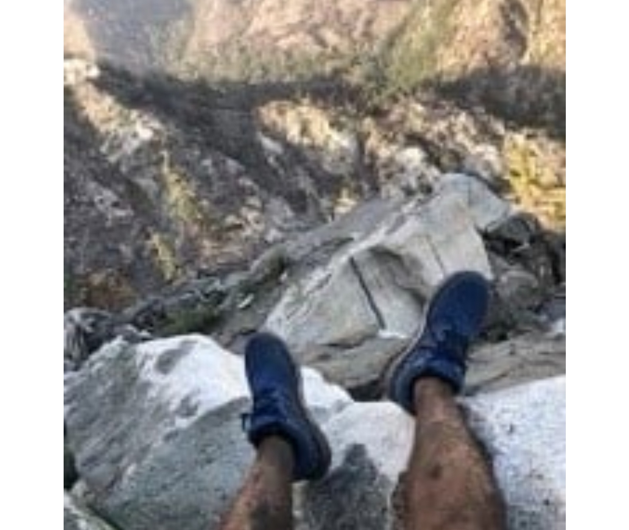
Rene Compean of Palmdale was on a hike Monday near Mount Waterman, a popular ski destination in the San Gabriel Mountains in Southern California. While the 45-year-old was on his outdoor adventure, he snapped a picture. It showed him from the knees down, dangling his bare legs from a precipice with a canyon below and slopes in the distance. Compean texted the shot to a friend. And then, he went off the map.
He was reported missing at 6 p.m. by a friend, who received one last text from Compean saying he was worried he was lost and his cell phone battery was running low. The photo was turned over to investigators at the Los Angeles County Sheriff’s Department who posted it to social media, asking if anyone recognized the spot in the photograph.
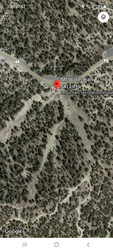
Benjamin Kuo saw the message and thought he might be able to help. As a satellite image aficionado, he was already familiar with tracking California wildfires in remote areas.
"I've got a very weird hobby, which is I love taking a look at photos and figuring out where they're taken," Kuo told NBC Los Angeles.
Using satellite images, maps and the scenery below Compean's feet in the photo, Kuo was able to estimate the coordinates of where he believed the man had gone missing. Kuo sent his tip to the sheriff's office, and a helicopter was sent to survey the area Tuesday. There, as if by magic, was Compean.
 = new reply since forum marked as read
Highlight:
NoneDon't highlight anything
5 newestHighlight 5 most recent replies
= new reply since forum marked as read
Highlight:
NoneDon't highlight anything
5 newestHighlight 5 most recent replies

soothsayer
(38,601 posts)
PoliticAverse
(26,366 posts)
mtngirl47
(1,224 posts)
GPV
(73,378 posts)PoliticAverse
(26,366 posts)
reACTIONary
(7,057 posts)... an Emergency Position Indicating Radio Beacon. They work with the SARSAT system to contact a search and rescue relay satellite. The system was set up for Safety of Life at Sea, but can be used for terrestrial search and rescue also.

PoliticAverse
(26,366 posts)and won't have a map you can use to find out where you actually are.
Great for emergency rescue (every boater that goes a significant distance from land should have an EPIRB).

central scrutinizer
(12,651 posts)It only cost $4.99 and it tells you exactly where you are, including the elevation. Works in airplane mode. Worked great even in Cuba. Of course, if there’s no signal, you can’t communicate your location.
Baitball Blogger
(51,896 posts)the area.

barbtries
(31,217 posts)Science!
that's a happy ending.

SleeplessinSoCal
(10,378 posts)Find that spot!

Harker
(17,557 posts)but, hey - I see my missing ski pole!
dalton99a
(92,843 posts)mainer
(12,514 posts)If it’s taken with an iphone?
Just wondering.

Bo Zarts
(26,260 posts)Pinpointing the exact location of a new fire start in the wilderness sometimes requires using all the tools in the box. And once the fire position is reported, I examine maps and Google Earth for the best routes in/out for firefighters and for hazards to aircraft.
Demovictory9
(37,113 posts)dlk
(13,183 posts)
world wide wally
(21,836 posts)Good call by Kuo