General Discussion
Related: Editorials & Other Articles, Issue Forums, Alliance Forums, Region ForumsTropical Storm watches for
A Tropical Storm Watch is in effect for...
* Anguilla and Barbuda
* St. Martin and St. Barthelemy
* Saba and St. Eustatius
* Sint Maarten
————
That is
Antigua and Barbuda
Anguilla is separate but should also be on that list
https://www.nhc.noaa.gov/text/refresh/MIATCPAT5+shtml/142352.shtml?
———-
By tomorrow Puerto Rico will have warnings .
The heavy stuff should stay in the Atlantic north of all the islands
 = new reply since forum marked as read
Highlight:
NoneDon't highlight anything
5 newestHighlight 5 most recent replies
= new reply since forum marked as read
Highlight:
NoneDon't highlight anything
5 newestHighlight 5 most recent replies

PJMcK
(25,126 posts)This chart of projected winds is sobering:
https://www.nhc.noaa.gov/refresh/graphics_at5+shtml/142352.shtml?tswind120#contents
It's that time of year again.
Be safe and stay vigilant.

malaise
(298,036 posts)from a major hurricane
PJMcK
(25,126 posts)... better a hurricane than a direct hit by an asteroid! (wink)
Seriously, any storm can be a bad day.
malaise
(298,036 posts)I’m ready for whatever shut is heading my way.
Can’t wait for November and six months of peace and quiet. Still we had no early ones this year. 😀

surfered
(14,318 posts)malaise
(298,036 posts)I am watchful and ready for whatever the hell comes my way. What I hate is the inconvenience associated with a hurricane. That said I do have really nice neighbours or it could be worse. We bring out board games and playing cards .😀

tavernier
(14,512 posts)Don’t panic. Make a plan and stick to it.
 ♥️
♥️
malaise
(298,036 posts)We have no other options 😀

BadgerMom
(3,437 posts)We’ve trimmed our vacation by a day in hopes of being able to get off the island and out of St. Thomas without incident. Fingers crossed! 🤞🏻
malaise
(298,036 posts)Here’s Erin on the move

BadgerMom
(3,437 posts)St. John to St. Thomas is another. Once the sea gets high, the ferries will stop. Determining when that will occur is a bit daunting.
And, thanks, Malaise, for tracking these things.
malaise
(298,036 posts)You may have to batten down and stay put
PJMcK
(25,126 posts)The waters between those islands can get pretty lively when a storm is brewing in the vicinity. My modest suggestion is simple: If you're going to leave, do it ASAP! Don't delay as conditions will only deteriorate. Alternatively, stay put and get comfortable and safe lodging as soon as you can.
Good luck! Stay safe!
malaise
(298,036 posts)It will become a hurricane any time now but should not reach near you before Saturday after lunch.
surfered
(14,318 posts)
cachukis
(4,084 posts)Justice matters.
(10,091 posts)Well, the westward line does: Hopefully not.
https://www.nhc.noaa.gov/storm_graphics/AT05/refresh/AL052025_5day_cone_no_line_and_wind+png/150247_5day_cone_no_line_and_wind.png

ancianita
(43,365 posts)
Still a TS

CaptainTruth
(8,261 posts)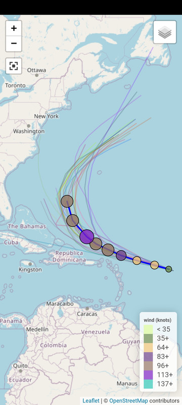
malaise
(298,036 posts)ancianita
(43,365 posts)

malaise
(298,036 posts)which is good for those likely to face outerbands.
This is a major hurricane.
ancianita
(43,365 posts)About those letters...
The legend on the map will typically provide a breakdown of these symbols, where:
D represents a Tropical Depression (wind speed less than 39 mph)
S represents a Tropical Storm (wind speed between 39 mph and 73 mph)
H represents a Hurricane (wind speed between 74 mph and 110 mph)
M represents a Major Hurricane (wind speed greater than 110 mph)
It's important to remember that this "H" indicates the forecast intensity at that time, and the actual strength of the storm can change as it develops or weakens.
By Thursday we can say one down, eight to go lol. 
malaise
(298,036 posts)Peak season approaches
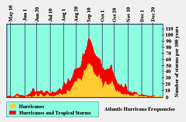
ancianita
(43,365 posts)Thanks for the frequency graph.

Deuxcents
(27,725 posts)malaise
(298,036 posts)Stay safe

Kick in to the DU tip jar?
This week we're running a special pop-up mini fund drive. From Monday through Friday we're going ad-free for all registered members, and we're asking you to kick in to the DU tip jar to support the site and keep us financially healthy.
As a bonus, making a contribution will allow you to leave kudos for another DU member, and at the end of the week we'll recognize the DUers who you think make this community great.