General Discussion
Related: Editorials & Other Articles, Issue Forums, Alliance Forums, Region ForumsSouthern California Storm (This is thread two)
Last edited Fri Feb 28, 2014, 01:00 AM - Edit history (5)
SDCountyDPW
Friday: Rain widespread and heavy at times, 2-4" coast and inland valleys, 3-5" foothills and mountain slopes, 4-8" south slopes, 1/2 - 1" deserts; snow 6-12" above 7000', 18" at 8000' Gale force gusts and rough seas with high surf.
Coastal Flood Warning
COASTAL HAZARD MESSAGE
NATIONAL WEATHER SERVICE SAN DIEGO CA
151 PM PST THU FEB 27 2014
...STRONG STORM SYSTEM TO IMPACT THE BEACHES FRIDAY MORNING
THROUGH EARLY MONDAY...
.A POWERFUL PACIFIC STORM WILL GENERATE LARGE...ROUGH SURF AND
STRONG RIP CURRENTS FRIDAY MORNING THROUGH EARLY MONDAY MORNING.
SURF WILL BEGIN TO INCREASE FRIDAY...AND PEAK SATURDAY. THE
COMBINATION OF HIGH SURF...HIGH TIDES ABOVE 6.5 FEET...STRONG
ONSHORE WINDS...AND RAINFALL RUN- OFF WILL LIKELY RESULT IN
WIDESPREAD MINOR COASTAL FLOODING...WITH MORE VULNERABLE AREAS
POSSIBLY EXPERIENCING MORE SIGNIFICANT COASTAL FLOODING WHICH
COULD RESULT IN PROPERTY AND STRUCTURAL DAMAGE ON FRIDAY. A LARGE
WEST-SOUTHWEST SWELL ARRIVING SATURDAY MORNING WILL LIKELY
GENERATE SURF UP TO 15 FEET ALONG THE BEACHES OF ORANGE AND SAN
DIEGO COUNTIES. THIS WILL CONTINUE THE THREAT OF MINOR TO
POSSIBLY MAJOR COASTAL FLOODING DURING TIMES OF HIGH TIDE FOR
SATURDAY. SWELL AND SURF WILL RAPIDLY SUBSIDE SUNDAY
AFTERNOON...ENDING THE COASTAL FLOODING THREAT. SURF IS FORECAST
TO FALL BELOW 7 FEET ON MONDAY.
CAZ042-043-280615-
/O.CAN.KSGX.BH.S.0005.140228T1200Z-140302T2100Z/
/O.UPG.KSGX.CF.A.0001.140228T1400Z-140302T0900Z/
/O.NEW.KSGX.CF.W.0001.140228T1400Z-140302T0900Z/
/O.NEW.KSGX.SU.Y.0004.140301T1200Z-140303T1200Z/
ORANGE COUNTY COASTAL AREAS-SAN DIEGO COUNTY COASTAL AREAS-
151 PM PST THU FEB 27 2014
...COASTAL FLOOD WARNING IN EFFECT FROM 6 AM FRIDAY TO 1 AM PST
SUNDAY...
...HIGH SURF ADVISORY IN EFFECT FROM 4 AM SATURDAY TO 4 AM PST
MONDAY...
...BEACH HAZARDS STATEMENT IS CANCELLED...
THE NATIONAL WEATHER SERVICE IN SAN DIEGO HAS ISSUED A COASTAL
FLOOD WARNING...WHICH IS IN EFFECT FROM 6 AM FRIDAY TO 1 AM PST
SUNDAY. A HIGH SURF ADVISORY HAS ALSO BEEN ISSUED. THIS HIGH SURF
ADVISORY IS IN EFFECT FROM 4 AM SATURDAY TO 4 AM PST MONDAY. THE
BEACH HAZARDS STATEMENT HAS BEEN CANCELLED. THE COASTAL FLOOD
WATCH IS NO LONGER IN EFFECT.
* CHANGES SINCE LAST ISSUANCE...CHANGED THE COASTAL FLOOD WATCH TO
A WARNING...ISSUED A HIGH SURF ADVISORY AND CANCELLED THE BEACH
HAZARDS STATEMENT.
* COASTAL FLOODING...WIDESPREAD MINOR COASTAL FLOODING EXPECTED
FRIDAY AND SATURDAY DURING TIMES OF HIGH TIDE. SOME MORE
VULNERABLE LOCATIONS MAY EXPERIENCE COASTAL FLOODING
SIGNIFICANT ENOUGH TO CAUSE PROPERTY DAMAGE AND INUNDATION OF
LOW-LYING BUILDINGS AND STRUCTURES ALONG THE BEACHES.
* COASTAL FLOODING LOCATIONS...SEAL AND SUNSET BEACHES...
CARDIFF...IMPERIAL BEACH...LA JOLLA SHORES AND NEWPORT BEACH
ARE JUST SOME OF THE LOCATIONS THAT ARE MOST VULNERABLE TO
COASTAL FLOODING.
* COASTAL FLOODING TIMING...FRIDAY MORNING THROUGH SATURDAY NIGHT.
COASTAL FLOODING MOST LIKELY DURING TIMES OF HIGH TIDE.
* TIDES...MORNING HIGH TIDES OF 6.0 TO 6.7 FT BETWEEN 8 AND 930
AM...AND EVENING HIGH TIDES OF 5.5 TO 5.8 FEET BETWEEN 9 TO 10
PM. HIGHEST HIGH TIDES WILL OCCUR FRIDAY MORNING.
* SURF...8 TO 12 FEET WITH SETS TO 15 FEET SATURDAY AFTERNOON AND
EVENING. SURF LOWERING TO 6 TO 9 FEET SUNDAY MORNING...AND
CONTINUE TO LOWER THE REST OF THE DAY.
* HIGH SURF TIMING...SATURDAY MORNING THROUGH EARLY MONDAY.
* IMPACTS...COASTAL FLOODING COULD CAUSE DAMAGE TO BEACH-FRONT
PROPERTY IF PROPER PRECAUTIONS ARE NOT TAKEN. LARGE AND ROUGH
SURF...ALONG WITH STRONG RIP CURRENTS...WILL CREATE HAZARDOUS
CONDITIONS FOR SWIMMERS AND SURFERS. SURF...LARGE TIDAL
SWINGS...AND PRECIPITATION MAY RESULT IN MODERATE TO
SIGNIFICANT BEACH EROSION.
PRECAUTIONARY/PREPAREDNESS ACTIONS...
A COASTAL FLOOD WARNING MEANS THAT FLOODING IS OCCURRING OR
IMMINENT. COASTAL RESIDENTS IN THE WARNED AREA SHOULD BE ALERT
FOR RISING WATER...AND TAKE APPROPRIATE ACTION TO PROTECT LIFE
AND PROPERTY.
A HIGH SURF ADVISORY MEANS THAT HIGH SURF WILL AFFECT BEACHES IN
THE ADVISORY AREA...PRODUCING RIP CURRENTS AND LOCALIZED BEACH
EROSION.
&&
$$
JJT
THE NATIONAL WEATHER SERVICE WANTS TO HEAR FROM YOU.
PLEASE VISIT THE FOLLOWING LINK TO GIVE US FEEDBACK
ON THE NEW BEACH HAZARDS STATEMENT:
HTTP://WWW.NWS.NOAA.GOV/SURVEY/NWS-SURVEY.PHP?CODE=CHMBHS
Viejas Alerts @ViejasAlerts now
Moreover, expect snow above 5500 feet, DPW is recommending people avoid the area if at all possible.
Expand Reply Delete Favorite More
Viejas Alerts @ViejasAlerts 40s
Palomar Mtn rainfall expected 9 - 11". Be alert for mud and debris flows. Storm #2 moves in early Friday with gale winds and heavy rain.
For those wondering what DPW is, that is the Department of Public Works, for the County of San Diego. I know, they are not official either according to some.
Moreover, here from LA Times,
The two storm systems are expected to move into Southern California starting Wednesday and will last through the start of the weekend.
The rainfall would bring little relief amid a state of emergency drought that was issued by Gov. Jerry Brown more than a month ago. Los Angeles County officials are asking residents and businesses to shut irrigation systems off.
http://www.latimes.com/local/lanow/la-me-ln-downtown-la-rainfall-storms-20140225,0,4421992.story#ixzz2uYcbClPj
Expect this to be a MAJOR flooding event. As watches are updated to warnings, I will make a point of updating.
By the way, for those not familiar with our geography or events, Palomar Mountain has three major fire scars.
Regardless my apologies for posting a non news item again. But once again, that non news might affect a few million people.
Oh and radar shows scattered showers over my area right at the moment, that is punch number one. Punch number two, well tomorrow it is expected to really hit the South Land hard.
Current NWS Western CONUS image
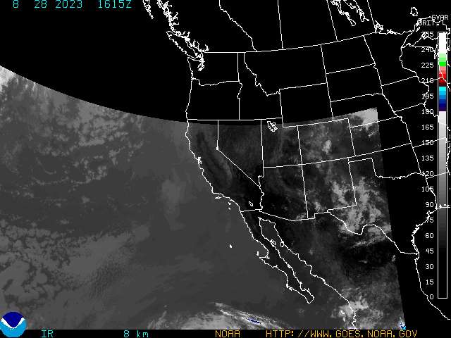
Yup, that is a large storm off shore
Oh and here another "unofficial" source with their hair on fire (Local Fire Department)
San Miguel Fire @SanMiguelFire 17m
NAT. Wx. Service. A STRONG STORM WILL BRING MODERATE TO HEAVY RAIN AND THE THREAT FOR FLASH FLOODING EARLY FRIDAY MORNING THROUGH SATURDAY.
And not surprising
Mandatory evacuations ordered in Azusa, Glendora ahead of storm
Fearing possible mudslides, Glendora and Azusa have issued mandatory evacuation orders for residents living in areas impacted by the Colby fire.
In Glendora, residents north of Sierra Madre Avenue between Yucca Ridge Road and Glendora Mountain Road must evacuate. In Azusa, the order applies to residents on Ridge View Drive.
Authorities have said that more than 1,000 homes are threatened by a possible mudslide and that the evacuations are being ordered as a precaution.
An evacuation center is located at the Crowther Center, 241 W. Dawson Ave., in Glendora.
http://www.latimes.com/local/lanow/la-me-ln-mandatory-evacuations-azusa-glendora-storms-20140227,0,7653649.story#ixzz2uYrnqOy2
Image with explanation

Need a sandbag? Remember to bring a shovel (SAN DIEGO SPECIFIC)
FREE Sand & Bags at these locations: (Remember to take a shovel.)
• Cal Fire Station 73: 28205 North Lake Wohlford Road, Valley Center
• Pauma Valley-Rincon, Cal Fire Station 70: 16971 Highway 76, Valley Center
• Cal Fire Station 50: 1587 Highway 78, Julian
• Alpine Fire Protection District, Station 17: 1364 Tavern Road, Alpine (Bags ONLY)
• Ramona Station: 3410 Dye Road, Ramona, CA
• North County Fire Protection District, Station 4: 4375 Pala Mesa Drive, Fallbrook
• Cal Fire Station 30: 17304 Highway 94, Dulzura
• Bonita/Sunnyside Fire Department: 4900 Bonita Road, Bonita
 = new reply since forum marked as read
Highlight:
NoneDon't highlight anything
5 newestHighlight 5 most recent replies
= new reply since forum marked as read
Highlight:
NoneDon't highlight anything
5 newestHighlight 5 most recent replies

PasadenaTrudy
(3,998 posts)in L.A. Gorgeous day. The calm before the storm, perhaps.
nadinbrzezinski
(154,021 posts)
cherokeeprogressive
(24,853 posts)Liberal_in_LA
(44,397 posts)Pretzel_Warrior
(8,361 posts)the random and spotty coverage of the nationwide issues around amber alerts, radiation, wind turbines and weather is much appreciated.
You many want to consider hiring staff to augment your efforts. maybe have them report by region.
pintobean
(18,101 posts)meteo
Aerows
(39,961 posts)spent their time giving a crap about each other instead of lobbing insults and snark at each other, this would be a far better place.
pintobean
(18,101 posts)Or, maybe the OP's sig line.
Aerows
(39,961 posts)it's not regional news. It's news.
pintobean
(18,101 posts)Aerows
(39,961 posts)A hell of a lot of people live in California, and Nadin is hardly the first person to report on regional weather when it is dangerous. I've certainly done it myself.
Giving a crap about other people and making certain they are informed about something that can adversely impact them is hardly something to complain about.
Pretzel_Warrior
(8,361 posts)why must everyone be entirely without a sense of humor. I can certainly take it when others take a shot at me.
Aerows
(39,961 posts)instead of unkind next time.
Pretzel_Warrior
(8,361 posts)Aerows
(39,961 posts)They have gone the heck away! If I never see another one ever again, it will be too soon for my liking.

Enthusiast
(50,983 posts)There they were. Three of them standing on the grate eating the chicken. It is a huge grill that holds 75 pounds of leg quarters at least. It had only just cooled off. The humans had already had plenty to eat by then anyway. Bandits. What a party that was.
nadinbrzezinski
(154,021 posts)Last edited Thu Feb 27, 2014, 05:46 PM - Edit history (1)
L.A. storms: 1,000 Glendora homes in path of potential mudslides
print
Fearing possible mudslides, Glendora and Azusa have issued mandatory evacuation orders for residents living in areas impacted by the Colby fire.
In Glendora, residents north of Sierra Madre Avenue between Yucca Ridge Road and Glendora Mountain Road must evacuate. In Azusa, the order applies to residents on Ridge View Drive.
Authorities have said that more than 1,000 homes are threatened by a possible mudslide and that the evacuations are being ordered as a precaution.
An evacuation center is located at the Crowther Center, 241 W. Dawson Ave., in Glendora.
http://www.latimes.com/local/lanow/la-me-ln-mandatory-evacuations-azusa-glendora-storms-20140227,0,7653649.story#ixzz2uYrnqOy2
Brother Buzz
(40,646 posts)But I read it in the mainstream media so it may be totally bogus information.
sadoldgirl
(3,431 posts)from a semi arid state.When a big storm was announced I grabbed bowls ,cans, even drums to collect the water to use it later on for my garden. Yes, it turned a bit in color by the time I used it, but the plants were happy. Of course, I did not worry at the time about the legality.
nadinbrzezinski
(154,021 posts) Lebam in LA
(1,360 posts)reminding me to pull out the rain barrels

Warpy
(114,766 posts)whenever I washed a load of clothes. The few things I'm actively growing in my otherwise parched yard appreciated it.
stopbush
(24,852 posts)It's supposed to rain thru Saturday. I hope it does.
nadinbrzezinski
(154,021 posts)I expect, after listening to the NWS meteorologist in the morning, for the watches to be raised to warnings. (And I hope to be dead wrong) As I said i a previous thread, the NWS is immensely conservative in issuing warnings. Look at the current image I just posted from satellite.
Intellicast has a nice interactive map.
And of course there is always the NWS.
The warnings from CALTRANS (A non official source according to some here) and my DPW are starting to be on the scary side. Hell, even SDG&E is getting into the warning people game. I wonder if they expect power outages (likely due to wind) all over the place.
stopbush
(24,852 posts)We didn't get much rain here today, and no wind, either. I'm hoping for more rain tomorrow. We need it.
nadinbrzezinski
(154,021 posts)and I hope DPW is dead wrong. None of us remembers 9-11 inches... none

madrchsod
(58,162 posts)and not a drop to drink.
9-11 inches over a week would be better.
nadinbrzezinski
(154,021 posts)but mother nature does not act that way.
rurallib
(64,939 posts)with more snow and then more cold this weekend.
Wish we could send you folks a few million carloads.
nadinbrzezinski
(154,021 posts)rurallib
(64,939 posts)no place to pile up any more.
nadinbrzezinski
(154,021 posts)by climate change, not at all.

Next year we expect an El Nino pattern to start to form, meaning wetter weather for So Cal. That is what the models show right at the moment.

KoKo
(84,711 posts)After all...huge amounts of our Produce and Wine comes from CA...and this drought will have an effect on all of us.
I don't know why anyone would discourage you from posting this kind of info. DU is a diverse community and we should be interested in Climate Actions/Weather where our DU Family is located.
nadinbrzezinski
(154,021 posts)anything. That is the truth. They engage in this kind of cyberstalking regularly and it is tolerated by the owners.
I have mostly given up on posting at this place. but this raises to the life\property standard, like Amber Alerts. So let the idiots show themselves for what they are, infantile children.
seveneyes
(4,631 posts)Some people have a need to poke others. Life is too short to allow them to control your actions. I appreciate and enjoy reading your threads.
nadinbrzezinski
(154,021 posts)I have a blog.
crazylikafox
(2,954 posts)I'm on the east coast, but I have a child in Southern CA. I like to know what's going on out there. Thanks for posting.
nadinbrzezinski
(154,021 posts)either on the radio, the computer, it really matters not. Though AM radio with batteries is not a bad idea, one with a weather band it is even better.
WillyT
(72,631 posts)


nadinbrzezinski
(154,021 posts) 
Blue_In_AK
(46,436 posts)It's shirt-sleeve weather in Anchorage -- sunny and 43 degrees.
nadinbrzezinski
(154,021 posts)was pushed northward per the NWS meteorologist. It is temporary, so expect this pattern to continue, Yup, shirt sleeve in anchorage.

sabrina 1
(62,325 posts)flickering right now, hoping the winds die down so we don't lose everything and end up with frozen pipes on top of everything else. We were joking one night about how cold it was here and decided to check on Alaska just for fun, it WAS warmer there.
And there is no such thing as climate change, just fyi! Lol!
Enjoy the balmy weather, I can't wait 'til we get above 30 degrees.
Blue_In_AK
(46,436 posts)not like winter at all. We sometimes get one or two brief warm-ups during the winter, but this year it's been one after another. I heard that we've had the normal amount of snow, but you wouldn't know it because there's been so much melting. Anchorage was more like Denver this year.

zappaman
(20,628 posts)
countryjake
(8,554 posts)can you please explain to me why you are so critical of Nadin's attempt to put out the news of this storm that may be devastating to many in California? Heavy rain after a long drought creates dangerous conditions, or don't you give a fuck about that?
It's been on all of our local news up here, and I'm not even in CA and we're not expected to be affected. Amazingly, some do care. What a concept! Too bad you're unable to grasp that.
http://www.cbsnews.com/news/california-cities-order-evacuations-ahead-of-powerful-storm/
LOS ANGELES -- Mandatory evacuation orders have been issued for 1,000 homes in two foothill suburbs east of Los Angeles in advance of a powerful storm.
The cities of Glendora and Azusa issued the orders at midday Thursday for homes that could be endangered by debris flows from nearly 2,000 acres of steep mountain slopes burned by a wildfire last month.
"You've got a recently burned hillside here with limited vegetation and a very steep slope. It's a recipe for what the experts say is potential for a great deal of damage," Sgt. John Madaloni told CBS Los Angeles.
For days, both cities have been making extensive preparations including sandbagging.
California received widespread rain Wednesday and early Thursday from the first of two back-to-back storms. The more powerful second storm is due overnight.
zappaman
(20,628 posts)Will try to live through it tonight.
Will keep you posted.
countryjake
(8,554 posts)When a poster's thread is derailed to the extent that Nadin's original one was, don't you agree that the point is lost? Why be so critical of a simple weather report that actually does concern many DUers here and actually would be of interest to others who don't even live in the affected area?
I honestly do not get it but I am glad that you consider yourself safe. I'm also happy that this drought will be getting a slight reprieve, and would be yanking the lids off of rain barrels if I lived down there.
zappaman
(20,628 posts)It got edited and seemed fine afterward.
Why another thread saying essentially the same thing is needed is beyond me.
Yeah, I'm safe although heavy rain usually means a leak in the kitchen that we can never track down the source from. So, time to get the bucket out.
Plus my dog is a wuss when it comes to rain, thunder and wind so I have to deal with her climbing on top of me and since she weights 75 lbs, that ain't fun.
But here in LA, we will get by...we are survivors.

questionseverything
(12,219 posts)is all I can figure out
you ought to see them go after anyone that suggests the radiation from japan is anything but GOOD for ya
I want to here about the west coast weather too and I like the personal imput this op gives
in Illinois we are having our 3rd "40 year event" in about a month so something odd is going on

SidDithers
(44,333 posts)What's your opinion of pretend meteorologist Kevin Martin?
Sid
medeak
(8,101 posts)to buy ice for power outages, where to pick up sand bags as have huge tides and heavy surf as well. Hope media blitz as reports vary from 2 inches to 8 inches of rain tomorrow with 55 mile gusts. Horrid wind last night and beach a mess with high surf washing up trash from ocean. Flooding already near beach. We picked up two huge garbage bags of plastic today. Looking forward to rain however!
crazylikafox
(2,954 posts)nadinbrzezinski
(154,021 posts)seveneyes
(4,631 posts)It looks like it may bring an ice storm here in the East Sunday or Monday.

Common Sense Party
(14,139 posts)Yikes.
nadinbrzezinski
(154,021 posts)I am being a good parrot, pass the gluten free cracker.
I just finished talking with a few back country folks. None of us remembers that, like ever. And I hope they are not just wrong, but dead wrong.
Common Sense Party
(14,139 posts)But that's way too much in one brief storm for super dry earth to soak up. The mudslides are going to be ugly.
nadinbrzezinski
(154,021 posts)if it does, well, I am glad I have a jeep. I usually cover fires on that mountain. There are three major fire scars at the moment.

AnotherDreamWeaver
(2,928 posts)I was going to college and working at a dairy, I had to drive a long way around to get to the freeway and go to school. Best Wishes for everyone down there.
nadinbrzezinski
(154,021 posts)oy.
Full tank, I got water and food bars... funny giving a talk on that disaster coverage soon.

kwassa
(23,340 posts)or at Mt. Pinos near Frazier Park.
Two outstanding experiences, because of the views out into the desert, the beauty of the pine forests, and the snow. I would love to do it again.
I did this in the early '90s. I remember that a 7-year California drought broke in March '94. Ski resorts that had already closed for the season re-opened. Looks like March is the magic month again, or so I hope.
We had been skiing for years at Mammoth Lakes on man-made snow, and then the winter of 94-95 had massive rain and snow, and then Mammoth had a 15 foot base of snow on the ground. The snow lasted so long that we all went up to Mammoth on the closing weekend, the 4th of July (though the snow was lousy by then).
Then I moved to the East Coast.

malaise
(299,735 posts)
nadinbrzezinski
(154,021 posts)Experiencing its driest year on record, large parts of California need well over 15 inches of rain to emerge from severe drought. A vigorous storm crashing into its central coast Friday will supply some much-needed rain, but perhaps too much at once. Forecasters warn strong winds, flash flooding, mud and debris flows, and even a few weak tornadoes may accompany the powerhouse weather system.
The incoming storm may be the largest rain event in Southern California since March 2011 says the National Weather Service.
http://www.washingtonpost.com/blogs/capital-weather-gang/wp/2014/02/27/desperately-dry-southern-california-to-get-deluged/
YAY, now it is officially NEWS.
lostincalifornia
(5,674 posts)flooding or damage.
nadinbrzezinski
(154,021 posts)to make sure you are not in the path of number two
lostincalifornia
(5,674 posts)never knows
Southern California does look like an issue though
nadinbrzezinski
(154,021 posts)before I check back on the NWS.

pinboy3niner
(53,339 posts)That's what I said when I read the forecast for flash floods, mudslides and debris flows. Well, I said something like that, anyway.
nadinbrzezinski
(154,021 posts)
madinmaryland
(65,823 posts)on Sunday and Monday for a hugh snow storm.
Watch out for mudslides.
nadinbrzezinski
(154,021 posts)The first storm mostly will affect you.
But now that you mention it.
The second storm I think it's mid week.
nadinbrzezinski
(154,021 posts)Last edited Thu Feb 27, 2014, 07:34 PM - Edit history (1)
Coastal Flood Warning
COASTAL HAZARD MESSAGE
NATIONAL WEATHER SERVICE SAN DIEGO CA
151 PM PST THU FEB 27 2014
...STRONG STORM SYSTEM TO IMPACT THE BEACHES FRIDAY MORNING
THROUGH EARLY MONDAY...
.A POWERFUL PACIFIC STORM WILL GENERATE LARGE...ROUGH SURF AND
STRONG RIP CURRENTS FRIDAY MORNING THROUGH EARLY MONDAY MORNING.
SURF WILL BEGIN TO INCREASE FRIDAY...AND PEAK SATURDAY. THE
COMBINATION OF HIGH SURF...HIGH TIDES ABOVE 6.5 FEET...STRONG
ONSHORE WINDS...AND RAINFALL RUN- OFF WILL LIKELY RESULT IN
WIDESPREAD MINOR COASTAL FLOODING...WITH MORE VULNERABLE AREAS
POSSIBLY EXPERIENCING MORE SIGNIFICANT COASTAL FLOODING WHICH
COULD RESULT IN PROPERTY AND STRUCTURAL DAMAGE ON FRIDAY. A LARGE
WEST-SOUTHWEST SWELL ARRIVING SATURDAY MORNING WILL LIKELY
GENERATE SURF UP TO 15 FEET ALONG THE BEACHES OF ORANGE AND SAN
DIEGO COUNTIES. THIS WILL CONTINUE THE THREAT OF MINOR TO
POSSIBLY MAJOR COASTAL FLOODING DURING TIMES OF HIGH TIDE FOR
SATURDAY. SWELL AND SURF WILL RAPIDLY SUBSIDE SUNDAY
AFTERNOON...ENDING THE COASTAL FLOODING THREAT. SURF IS FORECAST
TO FALL BELOW 7 FEET ON MONDAY.
CAZ042-043-280615-
/O.CAN.KSGX.BH.S.0005.140228T1200Z-140302T2100Z/
/O.UPG.KSGX.CF.A.0001.140228T1400Z-140302T0900Z/
/O.NEW.KSGX.CF.W.0001.140228T1400Z-140302T0900Z/
/O.NEW.KSGX.SU.Y.0004.140301T1200Z-140303T1200Z/
ORANGE COUNTY COASTAL AREAS-SAN DIEGO COUNTY COASTAL AREAS-
151 PM PST THU FEB 27 2014
...COASTAL FLOOD WARNING IN EFFECT FROM 6 AM FRIDAY TO 1 AM PST
SUNDAY...
...HIGH SURF ADVISORY IN EFFECT FROM 4 AM SATURDAY TO 4 AM PST
MONDAY...
...BEACH HAZARDS STATEMENT IS CANCELLED...
THE NATIONAL WEATHER SERVICE IN SAN DIEGO HAS ISSUED A COASTAL
FLOOD WARNING...WHICH IS IN EFFECT FROM 6 AM FRIDAY TO 1 AM PST
SUNDAY. A HIGH SURF ADVISORY HAS ALSO BEEN ISSUED. THIS HIGH SURF
ADVISORY IS IN EFFECT FROM 4 AM SATURDAY TO 4 AM PST MONDAY. THE
BEACH HAZARDS STATEMENT HAS BEEN CANCELLED. THE COASTAL FLOOD
WATCH IS NO LONGER IN EFFECT.
* CHANGES SINCE LAST ISSUANCE...CHANGED THE COASTAL FLOOD WATCH TO
A WARNING...ISSUED A HIGH SURF ADVISORY AND CANCELLED THE BEACH
HAZARDS STATEMENT.
* COASTAL FLOODING...WIDESPREAD MINOR COASTAL FLOODING EXPECTED
FRIDAY AND SATURDAY DURING TIMES OF HIGH TIDE. SOME MORE
VULNERABLE LOCATIONS MAY EXPERIENCE COASTAL FLOODING
SIGNIFICANT ENOUGH TO CAUSE PROPERTY DAMAGE AND INUNDATION OF
LOW-LYING BUILDINGS AND STRUCTURES ALONG THE BEACHES.
* COASTAL FLOODING LOCATIONS...SEAL AND SUNSET BEACHES...
CARDIFF...IMPERIAL BEACH...LA JOLLA SHORES AND NEWPORT BEACH
ARE JUST SOME OF THE LOCATIONS THAT ARE MOST VULNERABLE TO
COASTAL FLOODING.
* COASTAL FLOODING TIMING...FRIDAY MORNING THROUGH SATURDAY NIGHT.
COASTAL FLOODING MOST LIKELY DURING TIMES OF HIGH TIDE.
* TIDES...MORNING HIGH TIDES OF 6.0 TO 6.7 FT BETWEEN 8 AND 930
AM...AND EVENING HIGH TIDES OF 5.5 TO 5.8 FEET BETWEEN 9 TO 10
PM. HIGHEST HIGH TIDES WILL OCCUR FRIDAY MORNING.
* SURF...8 TO 12 FEET WITH SETS TO 15 FEET SATURDAY AFTERNOON AND
EVENING. SURF LOWERING TO 6 TO 9 FEET SUNDAY MORNING...AND
CONTINUE TO LOWER THE REST OF THE DAY.
* HIGH SURF TIMING...SATURDAY MORNING THROUGH EARLY MONDAY.
* IMPACTS...COASTAL FLOODING COULD CAUSE DAMAGE TO BEACH-FRONT
PROPERTY IF PROPER PRECAUTIONS ARE NOT TAKEN. LARGE AND ROUGH
SURF...ALONG WITH STRONG RIP CURRENTS...WILL CREATE HAZARDOUS
CONDITIONS FOR SWIMMERS AND SURFERS. SURF...LARGE TIDAL
SWINGS...AND PRECIPITATION MAY RESULT IN MODERATE TO
SIGNIFICANT BEACH EROSION.
PRECAUTIONARY/PREPAREDNESS ACTIONS...
A COASTAL FLOOD WARNING MEANS THAT FLOODING IS OCCURRING OR
IMMINENT. COASTAL RESIDENTS IN THE WARNED AREA SHOULD BE ALERT
FOR RISING WATER...AND TAKE APPROPRIATE ACTION TO PROTECT LIFE
AND PROPERTY.
A HIGH SURF ADVISORY MEANS THAT HIGH SURF WILL AFFECT BEACHES IN
THE ADVISORY AREA...PRODUCING RIP CURRENTS AND LOCALIZED BEACH
EROSION.
&&
$$
JJT
THE NATIONAL WEATHER SERVICE WANTS TO HEAR FROM YOU.
PLEASE VISIT THE FOLLOWING LINK TO GIVE US FEEDBACK
ON THE NEW BEACH HAZARDS STATEMENT:
HTTP://WWW.NWS.NOAA.GOV/SURVEY/NWS-SURVEY.PHP?CODE=CHMBHS
Also on the OP
crazylikafox
(2,954 posts)nadinbrzezinski
(154,021 posts)La Jolla, even where that house is. is not the worst of it. Pacific Beach, the San Diego River and OCEAN Beach will be fun, NOT
We have a bunch of homeless in the san diego river valley, not that many here care about them. Choppers were flying overhead for the last 48 hours.
indie9197
(509 posts)Lots of camps there too.
nadinbrzezinski
(154,021 posts)Until it dries.
SidDithers
(44,333 posts)I mean, once you got rid of the link and stuff from quack "meteorologist" Kevin Martin, there was good information from reputable sources.

Sid

greytdemocrat
(3,300 posts)This waiting is friggen torture!!! Die already!!!

Cleita
(75,480 posts)My info says it will hit about midnight with T storms.
nadinbrzezinski
(154,021 posts)are part of the weather product the NWS has put out.
Some of the warnings locally are down right apocalyptical, bad enough I filled the tank, and finished doing a gear check.
Cleita
(75,480 posts)from more than a decade ago. Too far buried in the junk though to dig them out.
nadinbrzezinski
(154,021 posts)my worst case, one of these critters makes it on land, (becoming a tornado) and does real damage. We are ready to go, I need to collapse my tripod though, been here ready for the fire bugs.
nadinbrzezinski
(154,021 posts)but it really must be a slow day in the Beltway, MSNBC just mentioned the mandatory evacs in LA (at Glendorra.)
We are now gone from non news to maybe news item.
nadinbrzezinski
(154,021 posts)High Wind Warning
URGENT - WEATHER MESSAGE
NATIONAL WEATHER SERVICE SAN DIEGO CA
115 PM PST THU FEB 27 2014
...STRONG AND GUSTY SOUTHWEST WINDS FRIDAY AND SATURDAY...
.A POWERFUL PACIFIC STORM WILL BRING STRONG AND DAMAGING WINDS
TO SOUTHERN CALIFORNIA FRIDAY THROUGH SATURDAY. THE WINDS WILL
INCREASE EARLY FRIDAY MORNING AND REMAIN STRONG THROUGH SATURDAY
BEFORE DECREASING SATURDAY NIGHT.
CAZ055-056-058-060>062-280515-
/O.UPG.KSGX.HW.A.0004.140228T0900Z-140302T0600Z/
/O.NEW.KSGX.HW.W.0004.140228T0900Z-140302T0600Z/
SAN BERNARDINO COUNTY MOUNTAINS-RIVERSIDE COUNTY MOUNTAINS-
SAN DIEGO COUNTY MOUNTAINS-APPLE AND LUCERNE VALLEYS-
COACHELLA VALLEY-SAN DIEGO COUNTY DESERTS-
115 PM PST THU FEB 27 2014
...HIGH WIND WARNING IN EFFECT FROM 1 AM FRIDAY TO 10 PM PST
SATURDAY...
THE NATIONAL WEATHER SERVICE IN SAN DIEGO HAS ISSUED A HIGH WIND
WARNING...WHICH IS IN EFFECT FROM 1 AM FRIDAY TO 10 PM PST
SATURDAY. THE HIGH WIND WATCH IS NO LONGER IN EFFECT.
* WINDS...SOUTH TO SOUTHWEST AT 25 TO 40 MPH...WITH GUSTS TO 65
MPH. ISOLATED GUSTS UP TO 75 MPH POSSIBLE.
* TIMING...LATE TONIGHT THROUGH SATURDAY EVENING.
* LOCATION...NEAR RIDGE TOPS AND ON ADJACENT DESERT AREAS.
* VISIBILITY...REDUCED AT TIMES IN BLOWING SAND AND DUST IN THE DESERT
AREAS.
* IMPACTS...GUSTY WINDS WILL MAKE DRIVING DIFFICULT...ESPECIALLY
FOR MOTORISTS WITH HIGH PROFILE VEHICLES. WATCH FOR BROKEN
TREE LIMBS AND OTHER DEBRIS.
* OUTLOOK...WINDS WILL WEAKEN SATURDAY NIGHT.
PRECAUTIONARY/PREPAREDNESS ACTIONS...
A HIGH WIND WARNING MEANS A HAZARDOUS HIGH WIND EVENT IS EXPECTED
OR OCCURRING. SUSTAINED WIND SPEEDS OF AT LEAST 40 MPH OR GUSTS
OF 58 MPH OR MORE CAN LEAD TO PROPERTY DAMAGE.
&&
$$
nadinbrzezinski
(154,021 posts)
If you have not done such, make sure your radios work, have extra batteries and have flashlights.
At least here the Wind warning extends to the coast, so we expect outages. I know, I know Mary sunshine here. But this is just common sense
Brother Buzz
(40,646 posts) hrmjustin
(71,265 posts)I wish CA the best!
nadinbrzezinski
(154,021 posts)but from a PM I was sent one of them crossed the line in a severe way. Mind you, not that I could alert in any way, shape or form. That does not work either. But asking if people are dead now, when the storm is dangerous enough where indeed people might die, is crossing severe lines.
I will continue to post HEALTH AND SAFETY, which this happens to fall as it. After that. I got a blog, there is facebook, I do not need this grief from cyberstalkers.
Now I'd better hit the rack early tonight. I expect a long day tomorrow.
And this is that post. Things like this should be an automatic hide.
57. Is everyone dead yet???
hrmjustin
(71,265 posts)nadinbrzezinski
(154,021 posts)actually has the potential to kill somebody.
Potential does not mean it is going to happen for sure, but if my DPW is even close... it could very well get very nasty, especially in rural areas.
hrmjustin
(71,265 posts)This storm coming to you will be here early next week.
nadinbrzezinski
(154,021 posts)punch two by midweek, so you will get it by next weekend. I am averaging how long they take to cross the country.
hrmjustin
(71,265 posts)nadinbrzezinski
(154,021 posts)nadinbrzezinski
(154,021 posts)Thursday's rainfall was just a drop in the bucket compared to what's coming.
"Everyone's going to see two to four inches of rain it looks like," said Alex Tardy, Operational Meteorologist with the National Weather Service. "And not over several days - in about a 24-hour to 36-hour period."
Add high winds to the mix and we're in for some debris blowing around, localized flooding and big surf along the coast. We might even see some water spouts in the ocean.
http://www.10news.com/news/san-diegos-friday-weather-forecast-a-months-worth-of-rain-all-in-one-day-022714
SidDithers
(44,333 posts)A second, stronger storm system will hit California on Friday and Saturday, generating 1 - 3" rainfall
totals for most coast and valley locations in Southern California, with 3 - 6" in the foothills and coastal mountain slopes. The powerful storm will be capable of spawning severe thunderstorms with wind gusts in excess of 58 mph, and a few waterspouts and weak tornadoes. The NWS office in Los Angeles is warning that Friday and Saturday's storm has the potential to bring rainfall rates of up to 1 - 2" per hour in the foothills and coastal mountain slopes, which will be capable of causing debris flows in areas recently burned by fires. About a foot of snow will likely fall from 6000 feet to 7000 feet, and 1 - 3' of snow is likely above 7000 feet. In the Sierras of Central California, 1 - 2' of snow is expected.
This storm, which has been named "Titan", will move eastwards over the weekend,and an Arctic front will combine with moisture associated with Titan to produce near-blizzard conditions across the northern Rockies Friday into Friday night. As it moves through the Central Plains, the storm will strengthen and begin to pull Gulf moisture northward into the cold air, triggering moderate to heavy snows across portions of Kansas, Nebraska and Missouri Saturday night into Sunday. The snow will spread across Illinois, Kentucky, Indiana, Ohio, West Virginia, and portions of the Mid-Atlantic and Northeast U.S. on Monday, and along the southern side of the snow band, a significant ice storm is likely. The ice storm will affect Oklahoma through Southern Missouri, northern Arkansas and northern Kentucky Saturday night and Sunday, and by Sunday night, parts of the Mid-Atlantic across Virginia and Maryland may also see significant icing. Small changes in the track of the storm will move the areas of freezing rain tens of miles north or south of the current forecast, so stay tuned to the latest forecasts.
Jeff Masters is a very good source for weather related information.
Sid
nadinbrzezinski
(154,021 posts)
wtmusic
(39,166 posts)Hallelujah.

nadinbrzezinski
(154,021 posts)I expect actual rain in fifteen minutes outside my windows.
Brother Buzz
(40,646 posts)Let 'er rip, I'm buttoned up tight.
rufus dog
(8,419 posts)Should be here in a couple of hours.
nadinbrzezinski
(154,021 posts)nadinbrzezinski
(154,021 posts)A storm cell has formed inland. It is raining now.

CaliforniaPeggy
(157,266 posts)nadinbrzezinski
(154,021 posts)trees down, looks like a derby out there, with the amount of crashes. Did I mention flow debris and rocks down from hills? So far no reports of any serious injuries in spite of the road derby out there.
nadinbrzezinski
(154,021 posts)Liberal_in_LA
(44,397 posts)nadinbrzezinski
(154,021 posts)and watching my back country, we actually had a TStorm warning for a little while.
pinboy3niner
(53,339 posts)But it was kind of nice sleeping to the music of the rain last night.
nadinbrzezinski
(154,021 posts)I felt sorry for them. It had not crested YET.
pinboy3niner
(53,339 posts)Most of the people in the mandatory evac areas have stayed put, for now.
nadinbrzezinski
(154,021 posts)TV needs images.

Lucinda
(31,170 posts)severe weather there...it was pretty much gorgeous the whole time I lived there...
Thanks for all the updates Nadin. ♥
nadinbrzezinski
(154,021 posts)Rain has been coming in heavy bursts. Some flooding reported, but no serious problems to report
The upper level low, which was expected to move into Central California, has intensified and instead appears to be headed for Southern California. Winds in the afternoon have picked up and are blowing strongly out of the south. We should expect more periods of heavy rain today and this evening associated with the bands out at sea. Thunderstorms have been rolling across the region this afternoon and will through tomorrow with a chance of waterspouts and weak tornadoes near the coast. The NWS still feels that we are on track for 2”-3” along the coast through Sunday morning, 3”-5” mountains with significantly higher amounts on the south-facing slopes of Palomar Mountain, and 0.5”-1” of rain in the deserts. Snow level should be dropping to 6000’ Saturday morning and 5000’-5500’ by Saturday evening. We should expect 3”-4” of snow at the higher elevations. ·
Skies begin to clear late Sunday as weak high pressure forms over the area early next week for fair and warmer temperatures.
DPW crews are on 12-hour shifts working round the clock to keep our roads safe and passable. Watch out for crews and equipment and don't park in the roadway. Chain requirements will be posted here and on Facebook.com/SDCountyDPW.
It has not been as bad, but the second batch is just starting to come in. NWS was warning yesterday of movement at the fire scars if this kept up.
We have had on and off TStorms all day, with possible water spouts. Oh and the CAD page for the CHP has been having major issues updating. (Which is hardly surprising)
nadinbrzezinski
(154,021 posts)Caltrans San Diego @SDCaltrans 10m
Rain, headlights, wipers, reduce speeds. Rain, headlights, wipers, reduce speeds. Rain, headlights, wipers, reduce speeds. Thank you.
nadinbrzezinski
(154,021 posts)last update for tonight. I think I am going to turn the 'puter off, and the scanner off.
nadinbrzezinski
(154,021 posts)The Weather Outlook -
The upper level low, which was expected to move into Central California, has intensified and instead appears to be headed for Southern California. Winds have picked up and are blowing strongly out of the south. We should expect more periods of heavy rain this evening associated with the bands out at sea. Thunderstorms have been rolling across the region and will continue through tomorrow with a chance of waterspouts and weak tornadoes near the coast. The NWS still feels that we are on track for 2”-3” along the coast through Sunday morning, 3”-5” mountains with significantly higher amounts on the south-facing slopes of Palomar Mountain, and 0.5”-1” of rain in the deserts. Snow level should be dropping to 6000’ Saturday morning and 5000’-5500’ by Saturday evening. We should expect 3”-4” of snow at the higher elevations. ·
Skies begin to clear late Sunday as weak high pressure forms over the area early next week for fair and warmer temperatures.
http://www.sdcdpw.org/emergency
Will check on NWS in a sec. And yes, the rain woke me up
nadinbrzezinski
(154,021 posts)Coastal Flood Warning
COASTAL HAZARD MESSAGE
NATIONAL WEATHER SERVICE SAN DIEGO CA
401 AM PST SAT MAR 1 2014
...LARGE SWELLS TO IMPACT THE BEACHES THROUGH EARLY MONDAY
MORNING...
.A POWERFUL PACIFIC STORM WILL GENERATE LARGE...ROUGH SURF AND
STRONG RIP CURRENTS THROUGH EARLY MONDAY MORNING. A LARGE
WEST-SOUTHWEST SWELL TODAY WILL PEAK THIS AFTERNOON AND LIKELY
GENERATE SURF UP TO 15 FEET ALONG THE BEACHES OF ORANGE AND SAN
DIEGO COUNTIES. THE COMBINATION OF LARGE SURF...HIGH TIDES ABOVE
6.5 FEET...STRONG ONSHORE WINDS...AND RAINFALL RUNOFF WILL LIKELY
RESULT IN WIDESPREAD MINOR COASTAL FLOODING. MORE VULNERABLE AREAS
MAY EXPERIENCE MORE SIGNIFICANT COASTAL FLOODING WHICH COULD
RESULT IN PROPERTY AND STRUCTURAL DAMAGE. SWELL AND SURF WILL
RAPIDLY SUBSIDE SUNDAY AFTERNOON...ENDING THE COASTAL FLOODING
THREAT. SURF IS FORECAST TO FALL BELOW 7 FEET BY EARLY MONDAY.
CAZ042-043-012030-
/O.CON.KSGX.CF.W.0001.000000T0000Z-140302T0900Z/
/O.CON.KSGX.SU.Y.0004.000000T0000Z-140303T1200Z/
ORANGE COUNTY COASTAL AREAS-SAN DIEGO COUNTY COASTAL AREAS-
401 AM PST SAT MAR 1 2014
...COASTAL FLOOD WARNING REMAINS IN EFFECT UNTIL 1 AM PST
SUNDAY...
...HIGH SURF ADVISORY REMAINS IN EFFECT UNTIL 4 AM PST MONDAY...
* COASTAL FLOODING...WIDESPREAD MINOR COASTAL FLOODING EXPECTED
DURING TIMES OF HIGH TIDE. SOME MORE VULNERABLE LOCATIONS MAY
EXPERIENCE COASTAL FLOODING SIGNIFICANT ENOUGH TO CAUSE
PROPERTY DAMAGE AND INUNDATION OF LOW-LYING BUILDINGS AND
STRUCTURES ALONG THE BEACHES.
* COASTAL FLOODING LOCATIONS...SEAL AND SUNSET BEACHES...
CARDIFF...IMPERIAL BEACH...LA JOLLA SHORES AND NEWPORT BEACH
ARE JUST SOME OF THE LOCATIONS THAT ARE MOST VULNERABLE TO
COASTAL FLOODING.
* COASTAL FLOODING TIMING...THROUGH TONIGHT. COASTAL FLOODING
MOST LIKELY DURING TIMES OF HIGH TIDE.
* TIDES...MORNING HIGH TIDES OF 6.0 TO 6.5 FT BETWEEN 8 AND 930
AM...AND EVENING HIGH TIDES OF 5.5 TO 5.8 FEET BETWEEN 9 AND 10
PM. HIGHEST HIGH TIDES WILL OCCUR IN THE MORNING.
* SURF...8 TO 12 FEET WITH SETS TO 15 FEET THIS AFTERNOON AND
EVENING. SURF LOWERING TO 6 TO 9 FEET SUNDAY MORNING...AND WILL
LOWER BELOW 7 FEET BY EARLY MONDAY MORNING.
* HIGH SURF TIMING...THIS MORNING THROUGH EARLY MONDAY MORNING.
* IMPACTS...COASTAL FLOODING COULD CAUSE DAMAGE TO BEACH-FRONT
PROPERTY IF PROPER PRECAUTIONS ARE NOT TAKEN. LARGE AND ROUGH
SURF...ALONG WITH STRONG RIP CURRENTS...WILL CREATE HAZARDOUS
CONDITIONS FOR SWIMMERS AND SURFERS. SURF...LARGE TIDAL
SWINGS...AND PRECIPITATION MAY RESULT IN MODERATE TO
SIGNIFICANT BEACH EROSION.
PRECAUTIONARY/PREPAREDNESS ACTIONS...
A COASTAL FLOOD WARNING MEANS THAT FLOODING IS OCCURRING OR
IMMINENT. COASTAL RESIDENTS IN THE WARNED AREA SHOULD BE ALERT
FOR RISING WATER...AND TAKE APPROPRIATE ACTION TO PROTECT LIFE
AND PROPERTY.
A HIGH SURF ADVISORY MEANS THAT HIGH SURF WILL AFFECT BEACHES IN
THE ADVISORY AREA...PRODUCING RIP CURRENTS AND LOCALIZED BEACH
EROSION.
&&
$$
THE NATIONAL WEATHER SERVICE WANTS TO HEAR FROM YOU. PLEASE VISIT
THE FOLLOWING LINK TO GIVE US FEEDBACK ON THE NEW BEACH HAZARDS
STATEMENT:
HTTP://WWW.NWS.NOAA.GOV/SURVEY/NWS-SURVEY.PHP?CODE=CHMBHS
HARRISON
Flood Advisory
FLOOD ADVISORY
NATIONAL WEATHER SERVICE SAN DIEGO CA
903 AM PST SAT MAR 1 2014
CAZ043-050-058-012000-
/O.NEW.KSGX.FA.Y.0010.140301T1703Z-140301T2000Z/
/00000.N.ER.000000T0000Z.000000T0000Z.000000T0000Z.OO/
SAN DIEGO COUNTY MOUNTAINS-SAN DIEGO COUNTY VALLEYS-
SAN DIEGO COUNTY COASTAL AREAS-
903 AM PST SAT MAR 1 2014
THE NATIONAL WEATHER SERVICE IN SAN DIEGO HAS ISSUED AN
* URBAN AND SMALL STREAM FLOOD ADVISORY FOR...
CENTRAL SAN DIEGO COUNTY IN SOUTHWEST CALIFORNIA...
* UNTIL NOON PST
* AT 856 AM PST SHOWERS AND THUNDERSTORMS CONTINUE TO FORM OFF SHORE
OF SAN DIEGO COUNTY AND ARE MOVING INLAND AT 25 MPH. THESE
SHOWERS AND THUNDERSTORMS ARE PRODUCING BRIEF PERIODS OF HEAVY
RAINFALL THAT WILL PRODUCE SOME PONDING OF WATER ON ROADWAYS...
RAPID RISES ON SMALL STREAMS AND DRAINAGE DITCHES.
* LOCATIONS IMPACTED INCLUDE...ALPINE...BONITA...BOSTONIA...
CHULA VISTA...EL CAJON...ESCONDIDO...GRANITE HILLS...HARBISON
CANYON...IMPERIAL BEACH...JAMUL...LA MESA...LAKESIDE...LEMON
GROVE...NATIONAL CITY...POWAY...RAMONA...RANCHO SAN DIEGO...SAN
DIEGO...SAN DIEGO COUNTRY ESTATES...SAN MARCOS...SANTEE...SPRING
VALLEY...VALLEY CENTER...DESCANSO...DULZURA...LAKE
HENSHAW...MIRAMAR...MIRA MESA...OAK GROVE...OTAY MESA...PALOMAR
MOUNTAIN...PAUMA VALLEY...POTRERO...RANCHO BERNARDO...SANTA
YSABEL...SAN YSIDRO AND THE WILD ANIMAL PARK.
PRECAUTIONARY/PREPAREDNESS ACTIONS...
MOST FLOOD DEATHS OCCUR IN AUTOMOBILES. NEVER DRIVE YOUR VEHICLE INTO
AREAS WHERE THE WATER COVERS THE ROADWAY. FLOOD WATERS ARE USUALLY
DEEPER THAN THEY APPEAR. JUST ONE FOOT OF FLOWING WATER IS POWERFUL
ENOUGH TO SWEEP VEHICLES OFF THE ROAD. WHEN ENCOUNTERING FLOODED
ROADS MAKE THE SMART CHOICE...TURN AROUND...DONT DROWN.
EXCESSIVE RUNOFF FROM HEAVY RAINFALL WILL CAUSE ELEVATED LEVELS ON
SMALL CREEKS AND STREAMS...AND PONDING OF WATER IN URBAN AREAS...
HIGHWAYS...STREETS AND UNDERPASSES AS WELL AS OTHER POOR DRAINAGE
AREAS AND LOW LYING SPOTS.
&&
malaise
(299,735 posts)<snip>
A very moist “Pineapple Express” atmospheric river of moisture from the Hawaiian Islands will bring much-needed rains to nearly all of drought-ravaged California Friday and Saturday. As of 8 am PST Friday, Downtown Los Angeles had received 1.17" of rain since midnight. It was the second consecutive day Los Angeles had received over 1" of rain, as 1.05" fell on Thursday. The last time Los Angeles had received more than 2" of rainfall in a 48-hour period was nearly 3 years ago--March 20 - 21, 2011, when 2.58” fell. Today's rains have forced the closure of a 10-mile stretch of the Pacific Coast Highway in Ventura County because of a high likelihood of rock slides in an area made bare by last year's Springs Fire in Camarillo, according to the Associated Press. Mandatory evacuation orders were also issued for about 1,000 homes in the eastern foothill suburbs of Glendora and Azusa, which lie beneath nearly 2,000 acres of steep mountain slopes denuded by the Colby fire in January. NOAA's Storm Prediction Center has placed coastal Southern California in their "Slight Risk" area for severe weather, with a few waterspouts and severe thunderstorms possible. Storm total rain amounts of 2 - 4 inches are expected through Saturday night at lower elevations in Southern California, with 4 -7" in the foothills and 8 - 10" in the mountains.
nadinbrzezinski
(154,021 posts)local flooding, nothing remarkable yet. I suspect yet is the operative word. The San Diego River is expected to go up by ten inches, near flood stage.
pinboy3niner
(53,339 posts)Didn't get too wet, but the clerks took pity on me and produced a plastic bag (now banned in CA) from the back.
nadinbrzezinski
(154,021 posts)lightning and thunder, nothing like two conures trying to climb humans. I might lose power on this one.
pinboy3niner
(53,339 posts)The ban just kicked in here in L.A. County. State Sen. Alex Padilla is sponsoring a bill for a statewide ban.
Good luck with your power. The biggest threat where I live is flash flooding. Sheriff's deputies and social workers did sweeps through homeless encampments in our desert arroyos over the past year, so I hope we won't see any lives lost there. Our local food bank/homeless shelter/resource center also arranged for additional homeless shelter space (60 more beds) at the local fairgrounds until late March.
nadinbrzezinski
(154,021 posts)And two conures are rather sticky. Thunder really scared them.
pinboy3niner
(53,339 posts)...I think I may have a recipe for you. 
Just kidding, just kidding. 
nadinbrzezinski
(154,021 posts)With that a few times. Cooking time will have to be tripled though, old 25 year old bird. He's tough. Right now he's eating. Ah more thunder.
pinboy3niner
(53,339 posts) nadinbrzezinski
(154,021 posts)He ran backwards, tripping over his tail feathers. It was funny. He's a regular clown though.
He does not like weather, or quakes.
pinboy3niner
(53,339 posts)With that many mouths to feed, rabbits and squab raised in the backyard were often on the menu. I still have flashbacks to The Silence of the Rabbits.
nadinbrzezinski
(154,021 posts)and it looks from radar reflectivity to be bad. Oh and the sky is quite the shade of gray. Batten down the hatches.
nadinbrzezinski
(154,021 posts)Aviation Weather Warning
CAC073-020230-
AIRPORT WEATHER WARNING FOR THE LINDBERGH FIELD AIRPORT
NATIONAL WEATHER SERVICE SAN DIEGO CA
433 PM PST SAT MAR 1 2014
...AN AIRPORT WEATHER WARNING IS IN EFFECT FOR SAN DIEGO
LINDBERGH FIELD FOR CLOUD TO GROUND LIGHTNING FROM 445 PM TO
630 PM...
AN AIRPORT WEATHER WARNING HAS BEEN ISSUED FOR LINDBERGH FIELD
AIRPORT. THUNDERSTORMS WITH CLOUD TO GROUND LIGHTNING WILL MOVE
OVER OR BE WITHIN 5 MILES OF THE AIRPORT FROM 445 PM TO 600 PM. THESE
THUNDERSTORMS WILL MOVE OUT OF THE AREA AFTER 630 PM.
Special Weather Statement
SPECIAL WEATHER STATEMENT
NATIONAL WEATHER SERVICE SAN DIEGO CA
415 PM PST SAT MAR 1 2014
CAZ042-043-048-050-055-057-058-020215-
SAN DIEGO COUNTY MOUNTAINS-
SAN DIEGO COUNTY VALLEYS-
SAN DIEGO COUNTY COASTAL AREAS-
ORANGE COUNTY COASTAL AREAS-
SAN BERNARDINO COUNTY MOUNTAINS-
SANTA ANA MOUNTAINS AND FOOTHILLS-
SAN BERNARDINO AND RIVERSIDE COUNTY VALLEYS -THE INLAND EMPIRE-
415 PM PST SAT MAR 1 2014
...SIGNIFICANT WEATHER ADVISORY FOR SOUTHWESTERN SAN BERNARDINO...
ORANGE...WESTERN RIVERSIDE AND WESTERN SAN DIEGO COUNTIES UNTIL 615
PM PST...
AT 406 PM PST...NATIONAL WEATHER SERVICE DOPPLER RADAR WAS TRACKING A
LINE OF THUNDERSTORMS 15 TO 30 SM OFF THE COAST...MOVING EAST AT 25
TO 35 MPH. INDIVIDUAL STORM CELLS ARE DRIFTING NORTH AT ABOUT THE
SAME SPEED WITHIN THE LINE ITSELF.
WIND GUSTS UP TO 50 MPH WITH HEAVY RAIN AND LOCAL PONDING OF WATER
ON ROADWAYS ARE EXPECTED AS THIS LINE OF STORMS MOVES ONSHORE. CLOUD
TO GROUND LIGHTNING AND PEA SIZED HAIL ARE ALSO POSSIBLE.
AREAS AFFECTED BY THIS STORM INCLUDE...MISSION VIEJO...LAGUNA
BEACH...IRVINE...RIVERSIDE...SANTA ANA...HUNTINGTON
BEACH...ONTARIO...SEAL BEACH...SAN
CLEMENTE...OCEANSIDE...ENCINITAS...AND SAN DIEGO.
PLEASE REPORT SIGNIFICANT WEATHER OR DAMAGE TO THE NATIONAL WEATHER
SERVICE SAN DIEGO TWITTER AND FACEBOOK PAGES.
LAT...LON 3253 11713 3266 11717 3267 11725 3282 11729
3287 11726 3299 11728 3319 11739 3344 11765
3375 11811 3394 11796 3396 11777 3411 11768
3426 11764 3416 11741 3379 11726 3352 11707
3296 11676 3258 11661
TIME...MOT...LOC 0008Z 180DEG 0KT 3345 11733
$$
zappaman
(20,628 posts)And I got wet.
Lesson learned.
Cleita
(75,480 posts)wet is the lesser of two evils. Weird cat.
zappaman
(20,628 posts)Odd...
sad-cafe
(1,277 posts)we just get snow and ice