General Discussion
Related: Editorials & Other Articles, Issue Forums, Alliance Forums, Region ForumsAnother couple of good graphics on MH370 search area (intercestion of arcs and maximum distance)
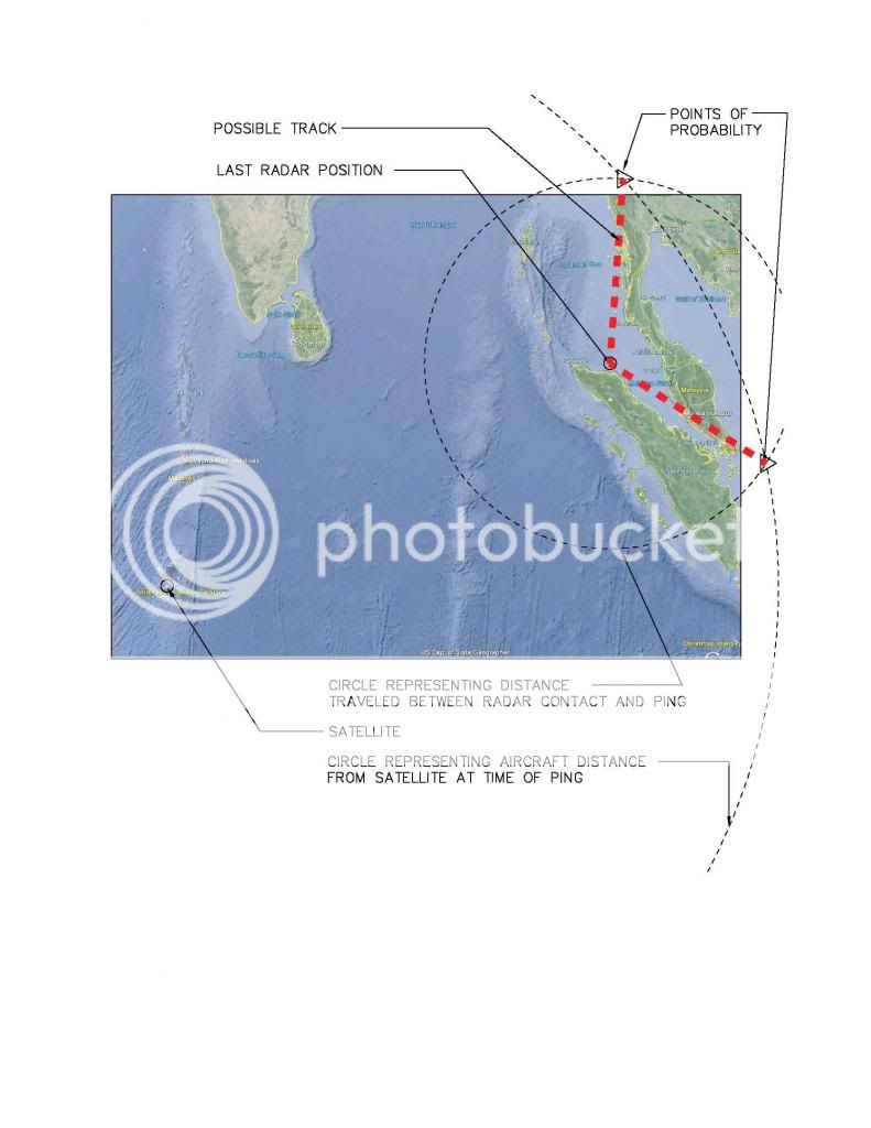
This one is good, because it give the intersection of the last signal (the arcs) and the maximum distance it could have traveled from the last known position. Assuming that the plane did not land an refuel before the arc ping, it would run out of fuel, land or crash somewhere near these intersections. What we don't know is, the direction, speed or elevation at the arc ping.

And, here is another graphic giving perspective to the search area (however they defined it):
 = new reply since forum marked as read
Highlight:
NoneDon't highlight anything
5 newestHighlight 5 most recent replies
= new reply since forum marked as read
Highlight:
NoneDon't highlight anything
5 newestHighlight 5 most recent replies

NightWatcher
(39,376 posts)lumberjack_jeff
(33,224 posts)are they saying that the satellite signal shows the bearing or that it shows the distance? In other words, was the plane somewhere in one of two pie-shaped areas or is it somewhere on one of those two arcs?
Also, wouldn't they know the time of that ping? Knowing the time elapsed between the last radar contact and the ping and knowing the flight speed would put another circle on the map.
FarCenter
(19,429 posts)By measuring the delay between the transmission of the ping and the reception of the reply, you know how far the plane is from the satellite. Knowing only distance you then can compute the circle on the earth's surface that is that far away. Unlike the pictures we see, there will be some uncertainty in the delay, and hence the distance. I'd think that the arcs are actually fairly wide bands.
What the maps also don't show is that if the plane isn't flying exactly along the circle of constant delay, successive pings will have different delay and hence locate the plane in different bands at different times.

muriel_volestrangler
(106,113 posts)FarCenter
(19,429 posts)morningfog
(18,115 posts)They knew the time of the ping, 8:11 AM. But they don't know the direction the place was heading, or the speed.
lumberjack_jeff
(33,224 posts)6 hours at 650mph is either Kazakhstan or deep in the South Indian Ocean, right? One assumes that there's little reason to hijack a plane to Antarctica.
Voice for Peace
(13,141 posts)muriel_volestrangler
(106,113 posts)The Maldives are 73 degrees E, 3 degrees N - about 3 quarters of the way from the last known radar contact to the point directly beneath the satellite. If it went that way, it would have to go even farther back to reach the arcs.
Voice for Peace
(13,141 posts)muriel_volestrangler
(106,113 posts)The direction they described (north to south) would not be a plane coming from the Malacca Strait - it would have had to turn 90 degrees for that. If the satellite contact wasn't known, it would seem more likely to be the Malaysian plane - the plane might have turned to attempt to land somewhere. But if the data from Inmarsat is accurate, it doesn't really fit. But another plane, with a bit of red and white on it, might be it. The details could be wrong, too - if it is a remote place, they may not be used to describing large planes.
Voice for Peace
(13,141 posts)I love having so many brains here on the forum:
collective madness sometimes, but a much
more rounded and informed perspective.

FightingIrish
(2,719 posts)The media keeps referring to the satellite arcs as “corridors” as though they represent some kind of track the plane would have followed. They are nothing more than “lines of position” (more correctly “arcs of position”) representing all the possible points equidistant from a satellite at the instant of one of the pings or “handshakes”. Most of the circle of equidistance is disregarded due to distance from the last point of contact or range of the aircraft. If you drew another circle showing the distance the plane would likely have traveled between the last radar sighting and the instant of the ping, you should have two overlapping circles and where they intersect would be two possible, although ambiguous, points of probability. In the old days when we relied on Loran for navigation we often only had a single Loran line (a parabola) to determine our position. Where we were along that line was the big question. If we were lucky we had an intersecting line of position from a celestial observation.
morningfog
(18,115 posts)by showing the intersection. The thing is, there are still too many unknowns for the intersection to be terribly helpful. It can help exclude some points beyond the maximum distance given the fuel.
However, that assumes that the plane did not refuel. That is a reasonable, if not likely, presumption, but still an unknown.
I think the best way to go about this would be to exclude as much as possible. Assume no refueling, everything outside the circle is gone. The points along the arcs in China and India should probably be excluded. I still don't see the southern arc providing a helpful reference point, given the previous known trajectory.
FightingIrish
(2,719 posts)This graphic is not intended to show the plane's location but a more logical method to determine it. You would need to know the time and location of the last radar position, the time of the ping and guess at the likely ground speed. The possible tracks would be the lines between the radar contact and the intersections of the two circles. This assumes that the ping occurred after the radar position which may not be the case. It also assumes that the plane did not change course between the two events. This confirms my position that they now can be reasonably certain that they don't know shit.
magical thyme
(14,881 posts)Thailand didn't give up the radar information until yesterday. It shows an unidentified plane in the appropriate time frame and possibly that flight, headed back toward Kuala Lumpur along the Malaysian Straight and then turning west toward a city called Butterworth.
Butterworth has a military airport with an 11,000 foot runway with sea approacha. It matches the pilot with the electrical fire theory, except suggests they initially headed back toward their takeoff point and then changed toward a different airport than he proposed. It may also explain why they are concentrating their search toward the southwest and why Australia joined it yesterday.
And Malaysia has received military radar from some other countries that they are unable to release. At least some countries in the area have been unwilling and/or slow to share information that they believe could compromise their security.
The combined intersection of all the data Malaysia has -- which is not shared with us -- may significantly shrink the possible crash (or landing) sites. There is a reason why they