General Discussion
Related: Editorials & Other Articles, Issue Forums, Alliance Forums, Region ForumsFlorida and South Carolina DUers - TD#3 and Tropical Storm Watches and Warnings
http://www.nhc.noaa.gov/storm_graphics/AT03/refresh/AL0316W5_NL+gif/150021W5_NL_sm.gifSUMMARY OF 1000 AM CDT...1500 UTC...INFORMATION
-----------------------------------------------
LOCATION...21.9N 88.1W
ABOUT 125 MI...200 KM NW OF COZUMEL MEXICO
ABOUT 550 MI...880 KM SW OF TAMPA FLORIDA
MAXIMUM SUSTAINED WINDS...35 MPH...55 KM/H
PRESENT MOVEMENT...N OR 360 DEGREES AT 8 MPH...13 KM/H
MINIMUM CENTRAL PRESSURE...1005 MB...29.68 INCHES
WATCHES AND WARNINGS
--------------------
CHANGES WITH THIS ADVISORY:
A Tropical Storm Warning has been issued for the Gulf coast of
Florida from Indian Pass to Englewood.
SUMMARY OF WATCHES AND WARNINGS IN EFFECT:
A Tropical Storm Warning is in effect for...
* Indian Pass to Englewood
A Tropical Storm Warning means that tropical storm conditions are
expected somewhere within the warning area within 36 hours.
Interests along the coast of northeastern Florida through southern
South Carolina should monitor the progress of this system.
For storm information specific to your area, including possible
inland watches and warnings, please monitor products issued by your
local National Weather Service forecast office.
DISCUSSION AND 48-HOUR OUTLOOK
------------------------------
At 1000 AM CDT (1500 UTC), the center of Tropical Depression Three
was located near latitude 21.9 North, longitude 88.1 West. The
depression is moving toward the north near 8 mph (13 km/h). A
north-northeastward motion at a faster forward speed is expected
later today through Monday. On this track, the center of the
depression is forecast to approach the coast of the Florida Big Bend
area Monday afternoon.
Maximum sustained winds are near 35 mph (55 km/h) with higher gusts.
Some strengthening is forecast, and the depression is expected to
become a tropical storm before reaching the coast of Florida.
The estimated minimum central pressure is 1005 mb (29.68 inches).
HAZARDS AFFECTING LAND
----------------------
RAINFALL...The depression is expected to produce rainfall amounts
of 3 to 5 inches with isolated maximum totals of 8 inches possible
across the northeastern Yucatan peninsula, western Cuba, and
Florida.
STORM SURGE...The combination of the storm surge and the tide will
cause normally dry areas near the coast to be flooded by rising
waters. The water could reach the following heights above ground
if the peak surge occurs at the time of high tide...
Indian Pass to Tampa Bay...1 to 3 ft.
Tampa Bay south to Florida Bay...1 to 2 ft.
The deepest water will occur along the immediate coast.
Surge-related flooding depends on the relative timing of the surge
and the tida cycle, and can vary greatly over short distances. For
information specific to your area, please see products issued by
your local National Weather Serive forecast office.
WIND...Tropical storm conditions are expected to first reach the
coast within the warning area by Monday afternoon.
TORNADOES...Isolated tornadoes are possible Monday afternoon across
portions of Florida and far southern Georgia.
NEXT ADVISORY
-------------
Next intermediate advisory at 100 PM CDT.
Next complete advisory at 400 PM CDT.
$$
Forecaster Brown
 = new reply since forum marked as read
Highlight:
NoneDon't highlight anything
5 newestHighlight 5 most recent replies
= new reply since forum marked as read
Highlight:
NoneDon't highlight anything
5 newestHighlight 5 most recent replies
djean111
(14,255 posts)Will be buying some extra food. We are told we will be getting a lot of rain, but I live in an area that does not flood. Just won't be driving around. Only bummer is I am supposed to take my lovely adopted heartworm-positive dog to the Humane Society for her second and third shots, on Tuesday and Wednesday. Four 40 mile round trips, I have to drop her off before 7:30 and pick her up after 3. Lots of traffic. Not looking forward to doing that in a tropical storm.
Take the dog next week - lots of rain in that system

Cassiopeia
(2,603 posts)Looks like Monday is going to be our rain day.
djean111
(14,255 posts)
malaise
(294,975 posts)DEPRESSION STRENGTHENS TO A TROPICAL STORM...
Reports from an Air Force Reserve Unit Hurricane Hunter aircraft
indicate that Tropical Depression Three is now a tropical storm
with maximum sustained winds of 40 mph (65 km/h).
SUMMARY OF 430 PM CDT...2130 UTC...INFORMATION
----------------------------------------------
LOCATION...23.3N 87.9W
ABOUT 465 MI...750 KM SW OF TAMPA FLORIDA
ABOUT 475 MI...765 KM SSW OF APALACHICOLA FLORIDA
MAXIMUM SUSTAINED WINDS...40 MPH...65 KM/H
PRESENT MOVEMENT...N OR 360 DEGREES AT 12 MPH...19 KM/H
MINIMUM CENTRAL PRESSURE...1005 MB...29.68 INCHES
$$
Forecaster Pasch

Lochloosa
(16,698 posts)malaise
(294,975 posts)and here's hoping you don't get too much of it
Lochloosa
(16,698 posts)
lpbk2713
(43,261 posts)I hope to make it through this one OK.
I made it through the three storms in six weeks time we had in 2004.
I doubt if we'll see another year like that one any time real soon.
malaise
(294,975 posts)

1939
(1,683 posts)The big danger and damage will come from the tornados that it spins off as it moves across land.
malaise
(294,975 posts)breeding grounds for those nasty mosquitoes

dixiegrrrrl
(60,154 posts)Of those, eight are predicted to become hurricanes and four are predicted to become major hurricanes.
Due to a combination of factors, this season is expected to be more active than any season in the past three years. Experts warn that those living along the Atlantic coast should be on alert.
http://www.accuweather.com/en/features/trend/atlantic_hurricane_season_forecast_2016_la_nina_above_normal_number_of_storms/57846987
malaise
(294,975 posts)those in the Gulf of Mexico and the Caribbean should also be on alert.
We've already had way more rain than we need - rainy season was very early

Raissa
(217 posts)... I had some low level flooding, but nearby streets were entirely underwater. I hope we don't get that kind of rainfall again this year. Its supposed to be a rare event in my area but with the changing environment I don't know if that's the case any longer.
malaise
(294,975 posts)Zika virus is around - watch the containers and places where water settles.

kentauros
(29,414 posts)One of the computer models has Invest 92E coming up after TS Colin. Most of the models for it don't have it crossing Mexico, but if it does, it's heading in almost the same path as Colin...
malaise
(294,975 posts)Good news so far is that they aren't strong
kentauros
(29,414 posts)One of them for Colin has it being a Cat-2 storm before landfall. None of the others ever make it that strong. So, you got to wonder what kind of data is being fed into that particular model...
malaise
(294,975 posts)the profit model 
kentauros
(29,414 posts)It would also make you win at Hurricane Bingo 

kentauros
(29,414 posts)as Colin won't be as bad as a Cat-2 hurricane:
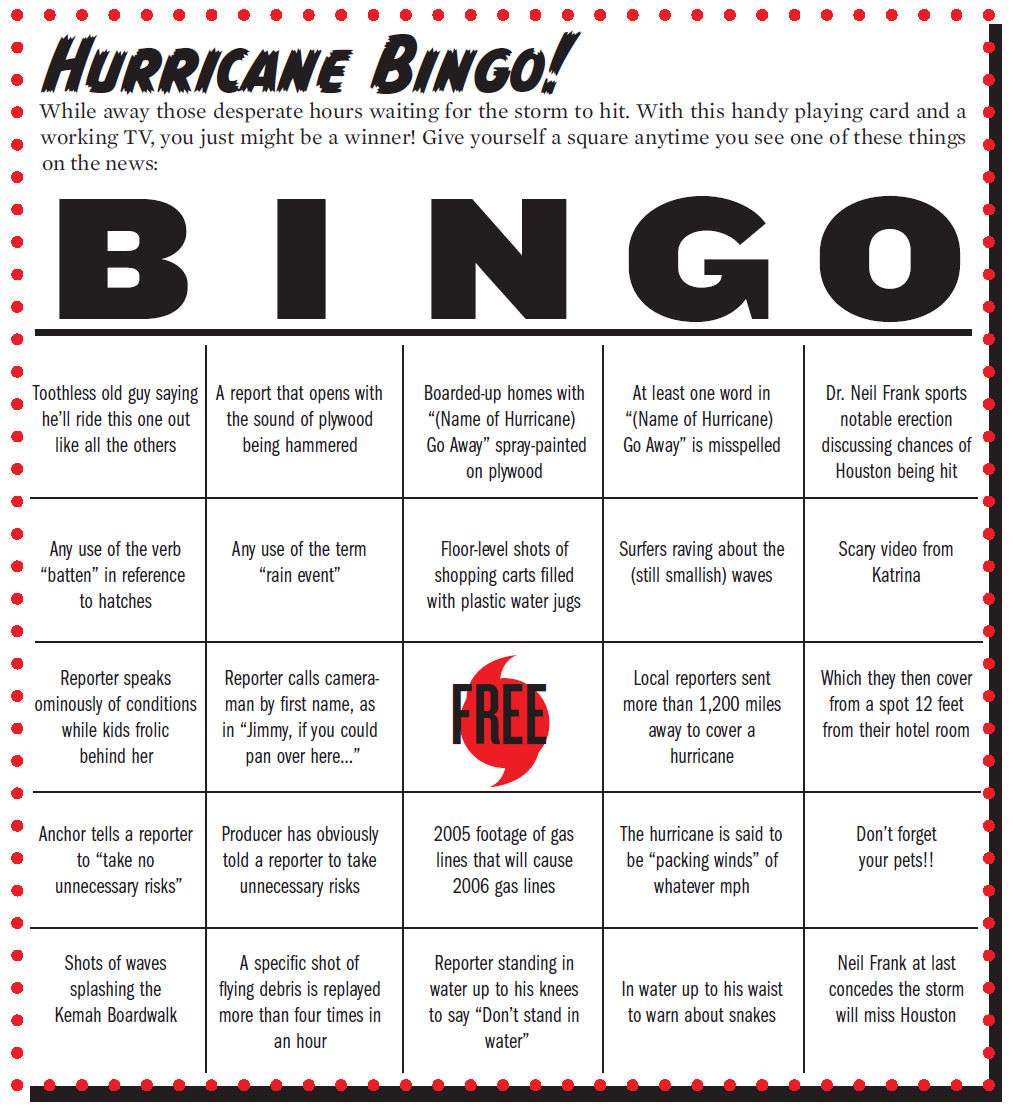
(This was originally made for Houston, so someone can redo it for their area.)
malaise
(294,975 posts)
kentauros
(29,414 posts)You'd think with stuff like this floating around that local news media would change the way they report storms. It's almost like they want people to mock them 
malaise
(294,975 posts) kentauros
(29,414 posts)
malaise
(294,975 posts) kentauros
(29,414 posts)Maybe with Photoshop? All I have is CS2, and I don't do Powerpoint. It does need to be updated, and created so that the dates, years, and places can be easily changed 
malaise
(294,975 posts)