General Discussion
Related: Editorials & Other Articles, Issue Forums, Alliance Forums, Region ForumsSome info on hurricane Irma - various models
full article http://abc11.com/weather/irma-should-i-be-worried/2364973/
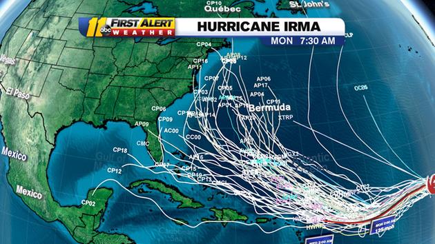
All of the current modeled paths
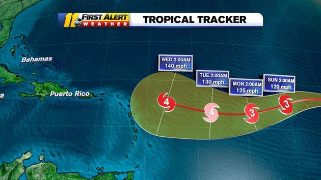
Forward tracker
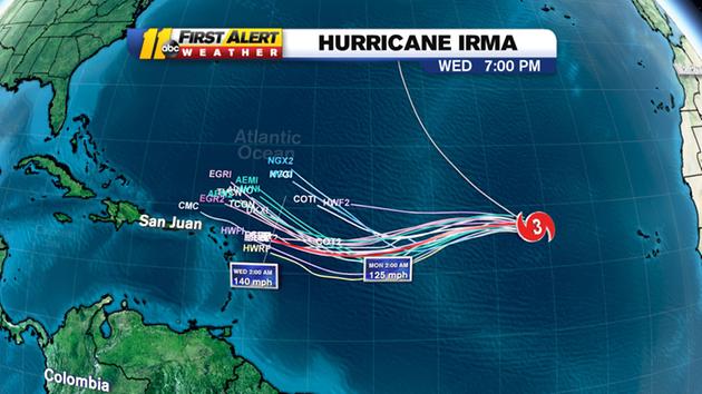
A more near-term spaghetti path model
current NOAA discussion -
000
WTNT41 KNHC 011450
TCDAT1
Hurricane Irma Discussion Number 9
NWS National Hurricane Center Miami FL AL112017
1100 AM AST Fri Sep 01 2017
Irma is undergoing an eyewall replacement cycle. The small eye is
becoming less distinct, with both microwave and visible imagery
indicating the presence of a forming outer eyewall. Satellite
intensity estimates are lower, so the initial wind speed is reduced
to 95 kt. Some further weakening is possible over the next day or
so while Irma moves over marginally warm SSTs and continues the
eyewall replacement. After that time, the environment should be
generally conducive for some restrengthening, although forecasting
the timing of eyewall replacement cycles is next to impossible. The
biggest change from yesterday are the long-term wind shear
predictions from the global models, which shows a little more shear.
Still, the shear is not that strong, and the hurricane will be
moving over 29C SSTs. Thus, the NHC intensity forecast is reduced
somewhat from the previous one, but remains near or slightly above
the model consensus.
Irma has turned a little bit to the left, now estimated to be
moving 285/11. The general synoptic situation remains well
established due to a building mid-level high, which should cause
the hurricane to turn westward later today and then move
west-southwestward through the weekend. An upper-level low will be
dropping southward on the east side of that high, and should be a
key feature to how far south Irma goes before eventually turning
westward and west-northwestward early next week. There is a
noticeable clustering of guidance by day 5, with the ECMWF, HWRF and
corrected-consensus models to the south, and the UKMET, GFS, CTC and
HMON to the north. Since Irma is forecast to be a vertically deep
cyclone, it seems more likely to respond to the northerly flow from
the upper-level low, which leads me to believe the track will be on
the southern side of the guidance. Thus, the forecast will stay
similar to the previous one, very close to the southern cluster
mentioned above.
FORECAST POSITIONS AND MAX WINDS
INIT 01/1500Z 18.5N 37.8W 95 KT 110 MPH
12H 02/0000Z 18.7N 39.5W 90 KT 105 MPH
24H 02/1200Z 18.5N 41.8W 90 KT 105 MPH
36H 03/0000Z 18.0N 44.2W 95 KT 110 MPH
48H 03/1200Z 17.3N 46.6W 100 KT 115 MPH
72H 04/1200Z 16.2N 51.0W 105 KT 120 MPH
96H 05/1200Z 16.7N 55.2W 110 KT 125 MPH
120H 06/1200Z 18.0N 59.5W 110 KT 125 MPH
$$
Forecaster Blake
 = new reply since forum marked as read
Highlight:
NoneDon't highlight anything
5 newestHighlight 5 most recent replies
= new reply since forum marked as read
Highlight:
NoneDon't highlight anything
5 newestHighlight 5 most recent replies

VMA131Marine
(5,198 posts)Still, the projections are all over the place at the moment.

underpants
(195,550 posts)Please please please don't let it go into the Gulf.
