General Discussion
Related: Editorials & Other Articles, Issue Forums, Alliance Forums, Region ForumsIMPORTANT: DON'T misinterpret the Hurricane Irma track maps...
In another thread, someone commented that the track for Irma was shifting west and that Miami was "in the clear". IT'S NOT!
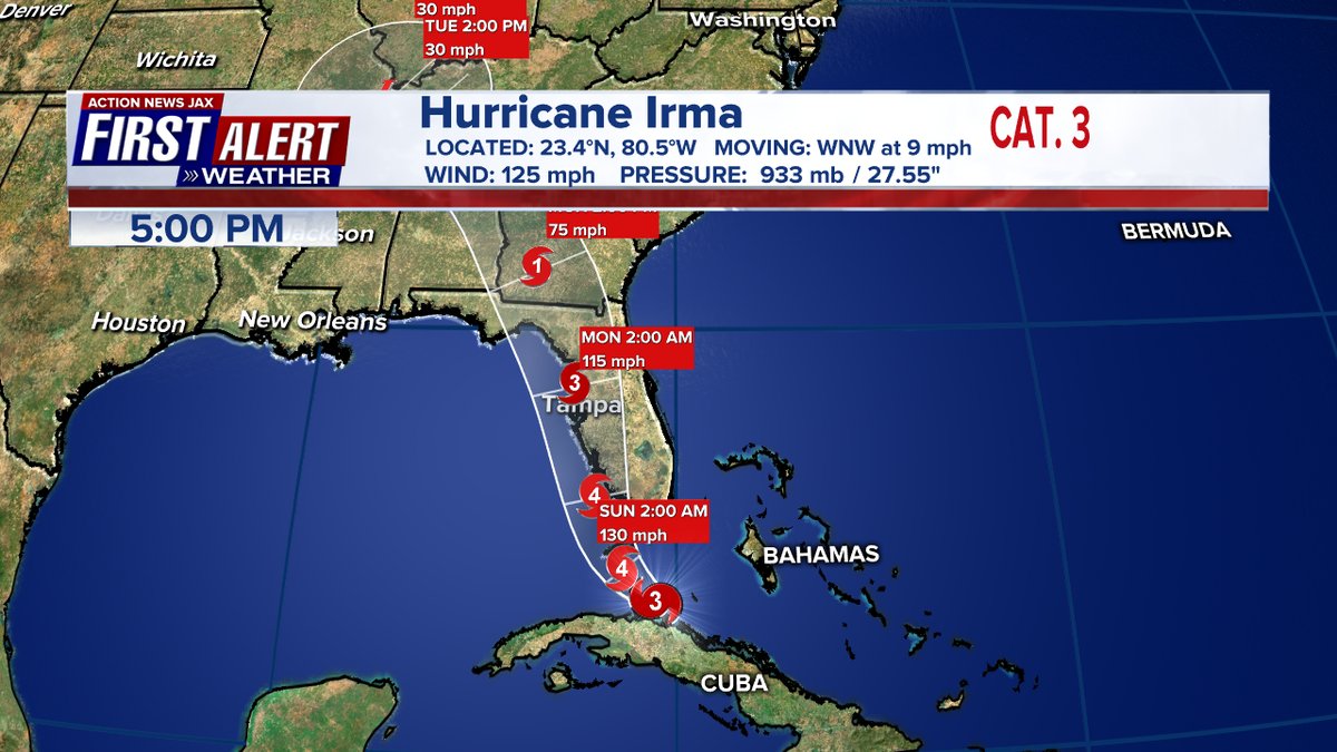
The hurricane maps posted by the NHC illustrate what's known as a "cone of uncertainty", which represents possible locations for the EYE of the Hurricane (the track line shows where the model guesses it will be, with the possibility of it moving east or west). The area surrounding the Eye of the Hurricane will be the worst in terms of wind, but the size and strength of Irma is so large that ANY part of Florida will be at risk for wind impacts. Add to which, Hurricanes spin counter-clockwise, which means the wind will be picking up AND PUSHING water from the Ocean, and Miami et. al. will be the first place to get storm surge and rain impacts.
There is NO safe place from Irma at this point. Don't underestimate it.
 = new reply since forum marked as read
Highlight:
NoneDon't highlight anything
5 newestHighlight 5 most recent replies
= new reply since forum marked as read
Highlight:
NoneDon't highlight anything
5 newestHighlight 5 most recent replies
dalton99a
(93,627 posts)
Glorfindel
(10,175 posts)I'm preparing here in the southern Appalachians in north Georgia for the worst. Hurricanes Opal and Ivan both did terrible damage here, and even a severe thunderstorm can knock out the electricity for days. 

AJT
(5,240 posts)Baitball Blogger
(52,162 posts)Miami is "in the clear" of a direct hit. But there will still be surges to worry about. I don't think brooklynite is characterizing my thread fairly.
The west coast is now dealing with the problems of evacuation that the east coast went through. Long traffic lines and less time to prepare to get out.

William769
(59,147 posts)Miami is out of the cone (meaning not a direct hit, that doesn't mean it won't be hit by the size, they just won't see the eye).
I am in Bonita.
Baitball Blogger
(52,162 posts)Think of how much better off we would be if we could have provided earlier warnings for the west coast. I have a friend who jumped in her car to leave yesterday and she's still stuck in traffic. She moved to the west coast a month ago!
cwydro
(51,308 posts)They are far from out of the woods.
Your thread was misleading, and I'm glad brooklynite posted this one.
Baitball Blogger
(52,162 posts)That is the area of most danger. What you refer to as the "dirty side." The further away you are from that nucleus, the further you are from the hurricane wind damage. The Keys will be devastated, but Miami is more than forty miles away and the storm is moving west. As has been reported, Miami will experience the surge, but they won't feel the devastating wind damage that destroyed Homestead with Andrew.
cwydro
(51,308 posts)This storm is 400 miles across, so being 40 miles away is not a big deal.
It's going over warm water, and is already re-strengthening.
Baitball Blogger
(52,162 posts)
Eyeball_Kid
(7,604 posts)Go to Intellicast, look a "Active Track".
AJT
(5,240 posts)
bigtree
(94,017 posts)...I don't think it'll hit as a 3, more likely 4-5, especially if it tracks for a Tampa landfall like the latest reports suggest.
AJT
(5,240 posts)
L. Coyote
(51,134 posts)
underpants
(196,022 posts)beachbum bob
(10,437 posts)nor the west coast of florida
Baitball Blogger
(52,162 posts)to a direct hit. I made it clear that there would still be danger from surges. That is still a huge improvement over what it was the day before. And, oh look someone saw the same thing I did:
Miami Beach official: "Cautiously optimistic"
Miami Beach City Manager Jimmy L. Morales tells CNN on Saturday that he's "cautiously optimistic" after overnight models showed the storm shifting west of Miami Beach. Morales cautioned still anticipates flooding. Miami Beach continues to expect significant storm surge. The Miami Beach Fire Department is moving its rescue vehicles inland to Miami in anticipation of flooding.
http://www.cnn.com/2017/09/09/us/hurricane-irma-florida-latest/index.html
AJT
(5,240 posts)The problem with 24 channels is they keep people watching by running around with their hair on fire as though they know that the worst that can happen will happen. With the next big storm people may stay put because they don't trust what they are hearing......the news channel that cried wolf.
Baitball Blogger
(52,162 posts)That is exactly what is going to happen. Keeping people on high anxiety as if they are going to get a direct hit is going to create long-term problems down the road. We should all be prepared, no doubt there. But don't overstate a situation to the point where there will be people who are going to question the source the next time a hurricane comes by.
cwydro
(51,308 posts)Everyone will get hit.

AHardRainsAGonnaFall
(11 posts)I had to turn off the t.v. everything is always over hyped. The weather stations are better. This is a dangerous storm that I hope will not cause too much pain and devastation.
I find myself getting sucked into the hype (on MSNBC) and then feel even more jaded and sceptical to the point I don't believe anything anymore.
SCVDem
(5,103 posts)on Rachel last night.
Winds at 100 even with a miss. Their meteorologist explained the situation very clearly.
As we all know, the flooding can be as bad as the wind.
Baitball Blogger
(52,162 posts)But there were updates this morning that we now have. They don't expect severe high winds for Miami, but they do expect surge. That's the update.
i.e. I don't think anyone was feeling optimistic enough to believe that Cuba could slow it down to a Cat 3, but it did. So, it might hit Florida as a Cat 4, but unlikely that it will come in as a Cat 5. We just need to keep watching.
GoCubsGo
(34,857 posts)The strongest part of the storm, including the highest winds, is the NE par of it. Which means it will impact the east coast of the state hardest, rather than being mostly out in the ocean. Miami isn't going to dodge any bullet. It's about to be blasted with them like it was the target of an Ouzi.
AJT
(5,240 posts)oberliner
(58,724 posts)This is a much much better scenario for Miami than previous.
Awsi Dooger
(14,565 posts)The projected path 48 hours ago would have been catastrophic for Southeast Florida. More than a generation to recover.
The so-called dirty side is obviously worse but it doesn't begin to counteract the save of 40 or 50 miles further removed from the eye wall.

George II
(67,782 posts)...and the storm is currently more than double that in diameter. So even if it moves up the west coast (looking now that it might barely skirt land), it will extend out into the Atlantic on the eastern side.
oberliner
(58,724 posts)They will be hit with wind and rain, but it's not unsafe across the majority of the state.
No one is recommending that 20 million people evacuate to Georgia.
George II
(67,782 posts)oberliner
(58,724 posts)But most folks in Florida are going to be fine (thankfully).

Old Vet
(2,001 posts)Iam hoping its not as bad as tv has been saying all week. My worry is Irma doesn't kick ass like everyone said and the hurricane behind it does.
cwydro
(51,308 posts)It will be going over very warm water, and it is likely to strengthen again.
L. Coyote
(51,134 posts)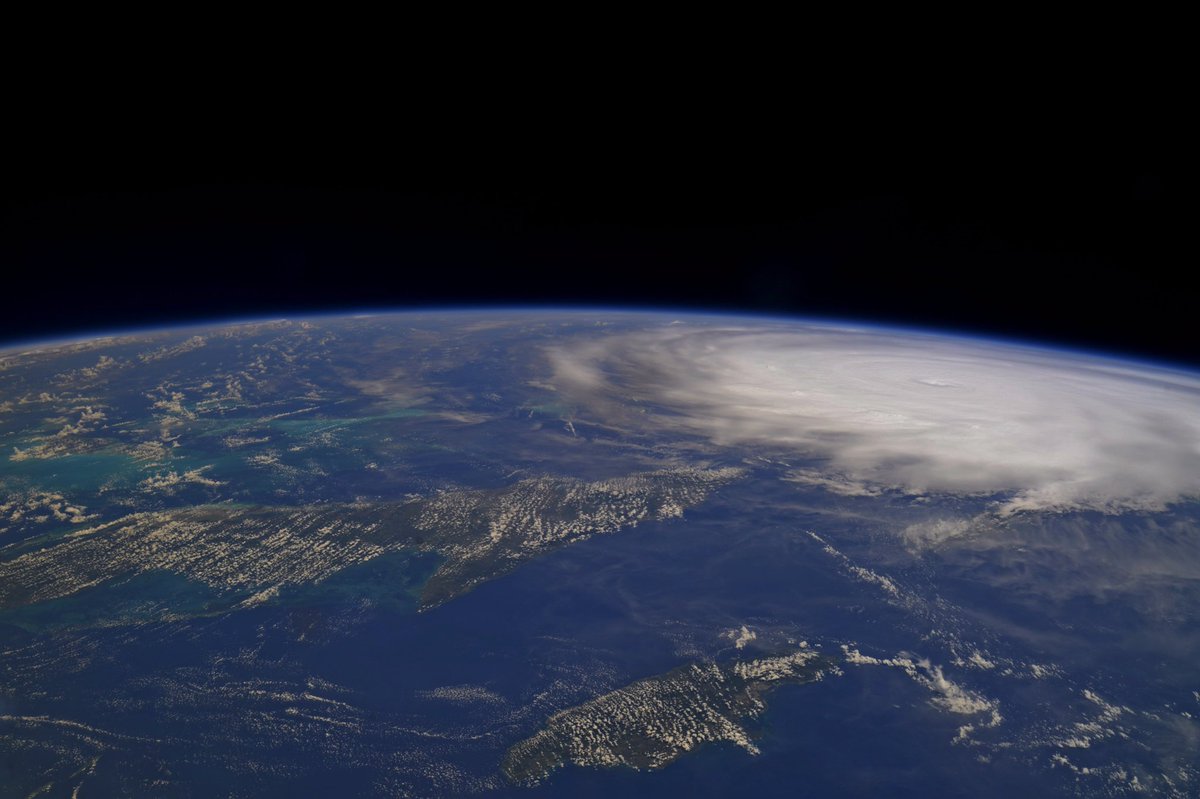

ananda
(34,883 posts)Miami will be on the dirty side of the storm.
It will not be pretty.
Amazed at some in this thread (and other threads) acting like "oh, no big deal now."
Old Vet
(2,001 posts)It was a observation that's all, Actually I hope this thing fizzles out to be honest. Maybe get lucky and this thing might take a hard, hard right.

ancianita
(43,256 posts)
Scurrilous
(38,687 posts)And we dodged a bullet. 120 miles from closest projected mainland landfall with hurricane force winds extending only 70 miles from Irma's eye. We'll get tropical force winds and a storm surge of 4 to 6 feet (last update). The west coast though is fucked..
L. Coyote
(51,134 posts)This storm could intensify and hit New Orleans, albeit that probability is low.

Rhiannon12866
(254,026 posts)Just the size seems to dwarf anything we have seen before. 


Pacifist Patriot
(25,210 posts)Explaining to people that the spaghetti lines and cone models do not represent the breadth of this storm.
My area is no longer showing as significant on these types of maps, but we are still projected to see sustained cat 1 winds and gusts of cat 2 force.