Latest Irma track shifts west with hurricane watch widened
Source: Miami Herald
Hurricane Irma tightened her grip on South Florida Friday, becoming what everyone has long dreaded: a monster hurricane bearing down on a region with nearly 7 million people.
Reliable forecast models projecting the storm’s path predictably began to agree on a final, fateful track, with a direct hit along the south coast Sunday after crossing the middle Keys — although any wobble at this point could still change the storm’s course. The latest forecasts continue to nudge the storm west, but even at two days tracks have an 80 to 90-mile margin of error, National Hurricane Center forecaster Mike Brennan said.
Irma is heading west and should continue moving in that direction over the next 24 hours, forecasters said Friday, with hurricane conditions in the Keys and mainland starting Saturday night. Tropical storm-force winds should start in the morning. Forecasters are increasingly concerned about flooding, with high storm surge and heavy rain expected and likely to occur at high tide in vulnerable places like Miami Beach.
...snip...
By late Saturday, the storm should begin making a critical turn to the north. But the turn will likely be too late to spare Florida from punishing hurricane winds that extend 70 miles from Irma’s center.
Read more: http://www.miamiherald.com/news/weather/hurricane/article171965332.html
Airport closes tonight. No transit service or Amtrak tomorrow and Sunday.
 = new reply since forum marked as read
Highlight:
NoneDon't highlight anything
5 newestHighlight 5 most recent replies
= new reply since forum marked as read
Highlight:
NoneDon't highlight anything
5 newestHighlight 5 most recent replies

mcar
(45,812 posts)Heading right up to my neighborhood. 


Skittles
(170,191 posts)

rzemanfl
(31,257 posts)It's heading this way.
Skittles
(170,191 posts)my meteorologist dad taught me to never fool with Mother Nature - well him and that Chiffon margarine gal 
rzemanfl
(31,257 posts)meteorologist who brought in the pressure wave recorded in Milwaukee when the Russians set off their 50 megaton bomb.
Skittles
(170,191 posts)I am flying there Sunday
rzemanfl
(31,257 posts)I wish I had flown to Milwaukee on Tuesday. Pack warm clothes.
Baclava
(12,047 posts)
SunSeeker
(57,882 posts)They didn't want to evacuate. I'm worried about them.

Sunlei
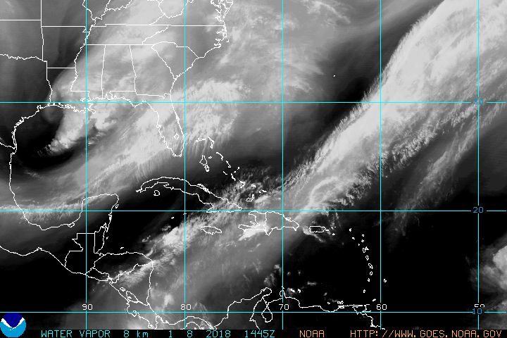
(22,651 posts)water vapor loop map!!! noooo!
Baclava
(12,047 posts)Maybe Cuba will knock it down some


modrepub
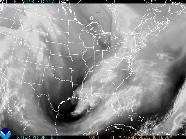
(4,018 posts)Most of western Cuba is flat so not much of a wind break so to speak (insensitive to wish Cubans take the brunt for US to avoid). The warmest and deepest waters move through the Keys to form the Gulf Stream. Storms passing over this usually get a jolt of energy (like Andrew did in 92). This sounds awful but Irma jogging to the left is better news if you live near Miami, worse news if you are in the keys. If Irma runs through the Everglades which are sparsely populated compared to Dade County then that's a break. Some energy should be taken out of the storm as it travels inland. This is not good news in any sense but it (may if it pans out) be slightly less worse. Remember right side of Hurricanes are the strongest.
Baclava
(12,047 posts)Last edited Sat Sep 9, 2017, 06:05 PM - Edit history (1)
 ?w=800&h=480
hatrack
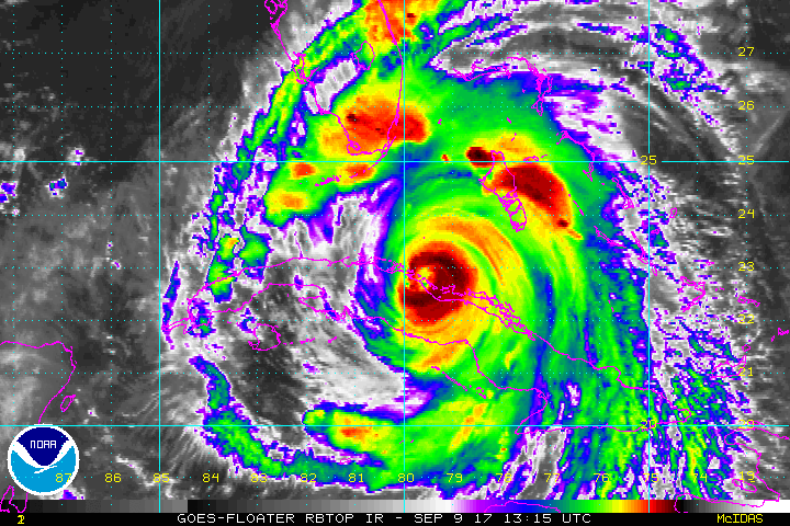
(64,485 posts)Not surprising, considering that she's at 155 mph sustained as we speak.
This is going to be one fucked-up mess.

SergeStorms
(20,200 posts)it's gone through it's eye-wall replacement and will gain strength. The barometric pressure is starting to fall again, and that's bad news. Hopefully some of it's strength will be scrubbed off along the northern coast of Cuba, but if it stays out over warmer water longer than expected..........
This afternoon I was thinking this Hurricane slightly reminded me of Katrina. Everyone expected Katrina to move up the Gulf coast of Florida, too. The rest, as we all know, is history, BAD history. Bottom line.......someone and someplace is going to get walloped. 'Tis the season.
SCantiGOP
(14,680 posts)Looks like I will avoid a Category 5 disruption of my peace - 12 of my in-laws from the SC Coast are packed and ready to come to my house in Columbia but looks like they will be staying in place with the new track.
If they do come, I have a fully stocked liquor cabinet and a promise of a handful of Xanax from a sister-in-law.

lark
(25,955 posts)Jacksonville has always been lucky with not getting a direct hit by a hurricane either before or since Dora in '64. I do feel sorry for people in So. fL. Our daughters' friend who lives in Ft. Lauderdale is staying with her here, much safer.

janx
(24,128 posts)It is 400 miles wide.
lark
(25,955 posts)However the difference between 75 mph and 140 mph is totally significant. We know we can survive 75 mph, done it before, no big sweat, over 100 is very scary when you live in an old growth oak forest.

csziggy
(34,189 posts)If that happens the worst side of the storm will be pushing water into Jacksonville & St. Mary's. I have a relative who just this past week moved from Texas to Jacksonville. Talk about bad timing!
Those big tree are terrifying in high winds! My Mom's house was surrounded by huge oaks. She has lost some since 2004 when all three storms passed over her house, but there are still giant oaks around her house. I'm trying not to worry but the waiting is hell.

tclambert
(11,187 posts)Baclava
(12,047 posts)Last edited Sat Sep 9, 2017, 10:47 PM - Edit history (1)


underpants
(195,550 posts)My wife an I spent a really great week there in 2003. Stayed in "Robert the doll"'s room.
Baclava
(12,047 posts)Live cam - people still out walking around
Baclava
(12,047 posts)My nephew in Pompano Beach decided to ride it out and not evacuate from the east coast - smart move - now all those people that moved north and east are stuck.
Heard reports of hundreds of people camped on the side of the road around Tallahassee, parked in cars by the rest-stop, run out of gas
OnlinePoker
(6,108 posts)He explains things so well.

Polly Hennessey
(8,660 posts)He is excellent. We want him. Send him to California.
Baclava
(12,047 posts)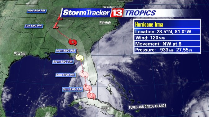 :large
Historic NY
(39,794 posts)in a new condo that is supposedly hurricane proof, niece is at the VA hospital there where they are evacuating patients northward. Hopefully the surge won't reach the second story.
Baclava
(12,047 posts)LOCATION...24.5N 81.5W
ABOUT 20 MI...30 KM ESE OF KEY WEST FLORIDA
ABOUT 110 MI...180 KM S OF NAPLES FLORIDA
MAXIMUM SUSTAINED WINDS...130 MPH...215 KM/H
PRESENT MOVEMENT...NNW OR 330 DEGREES AT 8 MPH...13 KM/H
MINIMUM CENTRAL PRESSURE...929 MB...27.43 INCHES
![]()
appal_jack
(3,813 posts)Baclava
(12,047 posts)LOCATION...25.0N 81.5W
ABOUT 80 MI...125 KM SSE OF NAPLES FLORIDA
ABOUT 115 MI...180 KM SSE OF FT. MYERS FLORIDA
MAXIMUM SUSTAINED WINDS...130 MPH...215 KM/H
PRESENT MOVEMENT...N OR 350 DEGREES AT 9 MPH...15 KM/H
MINIMUM CENTRAL PRESSURE...933 MB...27.55 INCHES
