Potential Tropical Cyclone Nine has ominous track
Source: WJAX News
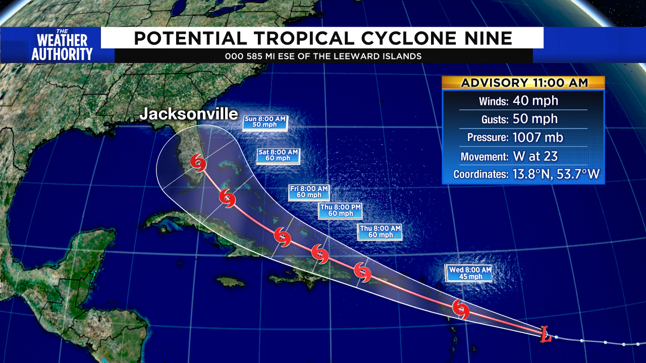
The good news about a newly developed potential tropical cyclone is that it’s not expected to become a hurricane but, unfortunately, it does look like rain and tropical-storm-force winds are possible along its path toward Florida by the weekend.
At 11 a.m., the disturbance was located 585 miles east-southeast of the Leeward Islands with 40 mph winds and a minimum pressure of 1007 MB. It is moving toward the west near 23 mph should continue during the next few days.
On the forecast track, the system is forecast to move through the Leeward Islands early Wednesday and near or over the Virgin Islands and Puerto Rico late Wednesday night and near or over Hispaniola on Thursday.
A Tropical Storm Warning is already in effect for Puerto Rico, including Vieques, Culebra and the U.S. Virgin Islands.
Read more: https://www.news4jax.com/weather/2020/07/28/new-potential-tropical-storm-nine-forms/
 = new reply since forum marked as read
Highlight:
NoneDon't highlight anything
5 newestHighlight 5 most recent replies
= new reply since forum marked as read
Highlight:
NoneDon't highlight anything
5 newestHighlight 5 most recent replies

Fritz Walter
(4,370 posts)Along with cases of bottled water, bleach, batteries, and granola bars.
Stay safe, y'all.

Leith
(7,864 posts)It's going to hit most of the countries & islands in the Caribbean!
I wonder if the US is preparing now...?  You know to help those in need?
heh - who am I kidding?

patphil
(8,838 posts)Wouldn't want anyone to say the FEMA cupboard was bare.

Leith
(7,864 posts)that he didn't do the least he could do.

groundloop
(13,632 posts)Still, even just the rain from that system could devastate Puerto Rico.

Warpy
(114,504 posts)This one is so far out, it's just as likely to go out to sea, it's far too early to tell.

modrepub
(4,019 posts)as you said but storm track is probably more accurate than intensity. If I were in southern Florida I'd start making preparations. You can't wait to the last minute if you have to evacuate. Too many people will be trying to do the same thing at the same time and it will be too late.
Hoping this thing is just a rain maker if it arrives in Florida as forecast or better yet goes out to sea or dissipates. Most governments have too much on their plate at the moment.

ancianita
(43,162 posts)If it revs up to hurricane level, it could travel differently from this track prediction.