Welcome to DU!
The truly grassroots left-of-center political community where regular people, not algorithms, drive the discussions and set the standards.
Join the community:
Create a free account
Support DU (and get rid of ads!):
Become a Star Member
Latest Breaking News
Editorials & Other Articles
General Discussion
The DU Lounge
All Forums
Issue Forums
Culture Forums
Alliance Forums
Region Forums
Support Forums
Help & Search
Hurricane Zeta forecast to be Category 2 storm at landfall in southeast Louisiana: See track
Source: Times-Picayune
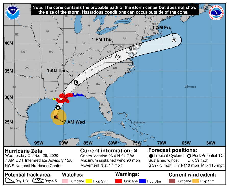
Hurricane Zeta is expected to be a Category 2 storm at landfall in southeast Louisiana, forecasters said Wednesday morning.
The storm strengthened overnight and now is forecast to have winds of 100 mph before landfall.
Life-threatening storm surge and damaging winds are expected in southeast Louisiana starting around mid-day Wednesday, forecasters said. Landfall is expected Wednesday afternoon.
Watches and warnings are in effect for southeast Louisiana. Metro New Orleans is under a hurricane warning.
Read more: https://www.nola.com/news/hurricane/article_c398ddfa-190b-11eb-a1b9-0bda3e044da5.html
4 replies
 = new reply since forum marked as read
Highlight:
NoneDon't highlight anything
5 newestHighlight 5 most recent replies
= new reply since forum marked as read
Highlight:
NoneDon't highlight anything
5 newestHighlight 5 most recent replies
= new reply since forum marked as read
Highlight:
NoneDon't highlight anything
5 newestHighlight 5 most recent replies
Hurricane Zeta forecast to be Category 2 storm at landfall in southeast Louisiana: See track (Original Post)
brooklynite
Oct 2020
OP

Ferrets are Cool
(23,065 posts)1. Yeah, we are on the "bad" side of it


underpants
(197,782 posts)2. It's might merge with Winter Storm Billy too
But that should just be a massive amount of rain dumped on the east coast

ScratchCat
(2,753 posts)3. Weird, not one model predicted this
No model had this over a low Cat 1 yesterday and they said there was really nothing that could cause this to intensify. We really need a not-for profit weather channel because this "make it up as you go along to get viewers" is for shit.

yaesu
(9,449 posts)4. Latest H center maps show a more southern path in AL showing tropical storm winds central/south
AL starting around 1-2AM, not a big deal for them, a really fast mover so rain won't be a concern.