NOAA predicts below-normal hurricane season amid building El Nio
Source: The Hill
05/21/26 8:21 PM ET
The National Oceanic and Atmospheric Administration (NOAA) on Thursday predicted that the upcoming Atlantic hurricane season could be below normal as El Niño intensifies amid its development.
NOAA’s outlook predicts a 55 percent chance of a below-normal season, with between eight and 14 named storms likely to develop. Between three and six of those storms should develop into hurricanes, including one or three that become category 3, 4, or 5 major hurricanes. Hurricane season starts June 1 and lasts until Nov. 30.
El Niño, the weather pattern where water temperatures near the equator of the central and eastern Pacific Ocean rise above the historic average for months at a time, will develop and intensify. These conditions typically support fewer tropical storms and hurricanes, with warmer water temperatures and low winds possibly leading to a more active season in 2027.
“Although El Niño’s impact in the Atlantic Basin can often suppress hurricane development, there is still uncertainty in how each season will unfold,” NOAA’s National Weather Service Director Ken Graham said in a report. “That is why it’s essential to review your hurricane preparedness plan now. It only takes one storm to make for a very bad season.”
Read more: https://thehill.com/policy/energy-environment/5890522-noaa-predicts-below-normal-hurricane-season/
NOAA/NCEP Climate Peediction Center (CPC) most recent REPORT - EL NIÑO/SOUTHERN OSCILLATION (ENSO) DIAGNOSTIC DISCUSSION
CLIMATE PREDICTION CENTER/NCEP/NWS
14 May 2026
ENSO Alert System Status: El Niño Watch
 = new reply since forum marked as read
Highlight:
NoneDon't highlight anything
5 newestHighlight 5 most recent replies
= new reply since forum marked as read
Highlight:
NoneDon't highlight anything
5 newestHighlight 5 most recent replies

WestMichRad
(3,400 posts)Last year’s forecast was for an above-average number of hurricanes etc., but it didn’t turn out that way. Unless perhaps you count all the fish storms that stayed offshore.
So, maybe they are right… but maybe not. And it only takes one tragically placed devastating storm to make it a bad hurricane year.

BumRushDaShow
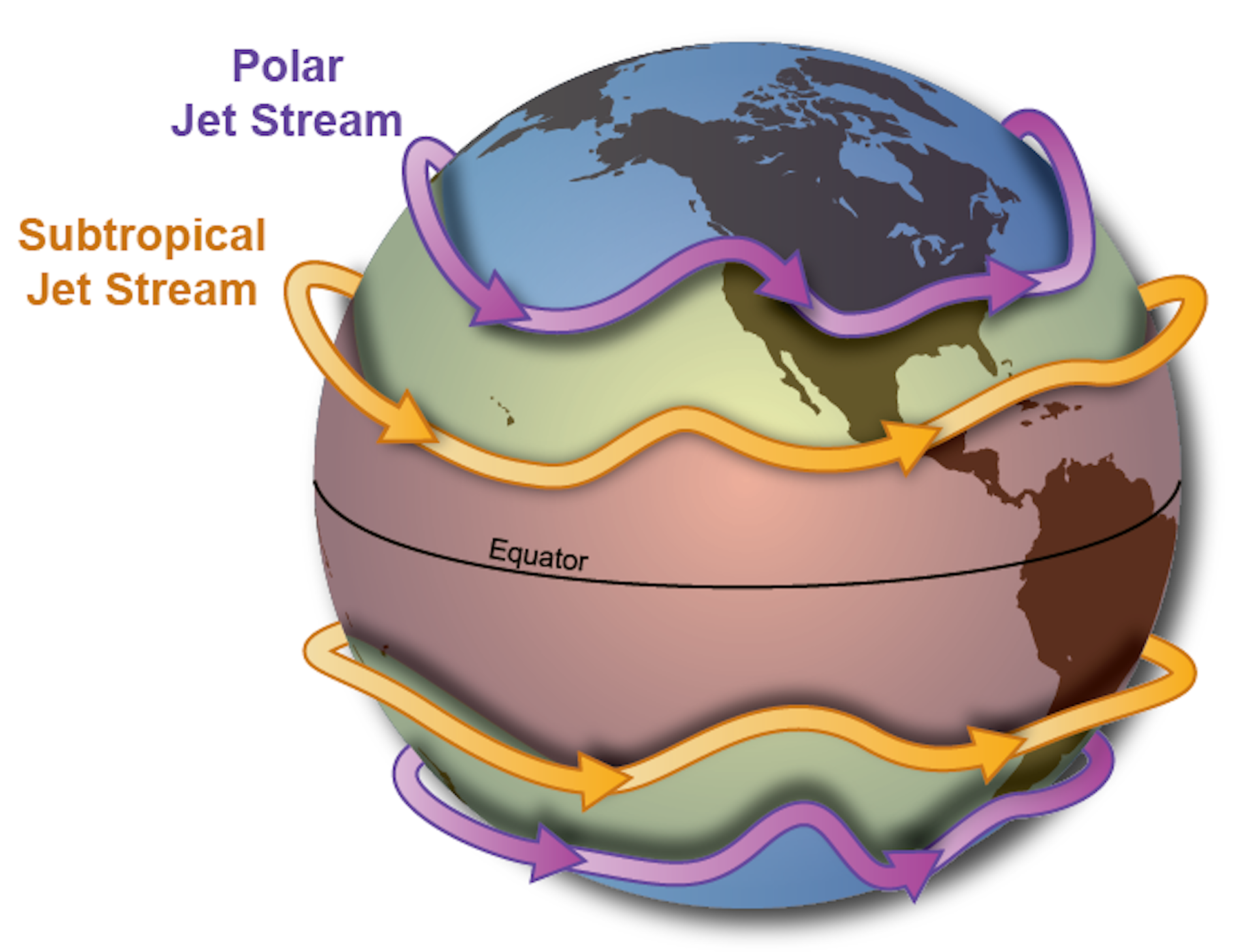
(172,425 posts)The 2024 - 2025 season featured a weak Nina so the shearing was definitely going on with a stronger than usual STJ that pushed storms away from the coasts along with dips in the Polar jet that continued to steer the storms away.

Anything that scooted below the STJ was able to get further west (like the one that hit Jamaica last year) before it got caught up in it.
This actually has a good description of what happened - https://www.wric.com/news/2025s-extreme-weather-had-the-jet-streams-fingerprints-all-over-it-from-flash-floods-to-hurricanes/
DemocracyForever
(192 posts)because of our warming planet and at a faster rate than the land is warming. Warmer air holds more moisture. This is what's supercharging both hurricanes and typical rainstorms. NYC just got flooded because of such a rainstorm. I no longer trust any NOAA forecasts because the odds that the forecasting is being done by actual climate scientists rather than a no science Trump stooge are pretty low.