The DU Lounge
Related: Culture Forums, Support ForumsMaps That Show How The World Really Is
This is a really interesting website.
https://www.travlerz.com/en/40-maps-that-show-how-the-world-really-is
For instance:
The Actual Population Dispersion Of The United States
The United States has a population size of just over 300 million. You would think that Americans would be evenly dispersed throughout the States, but this is not the case.
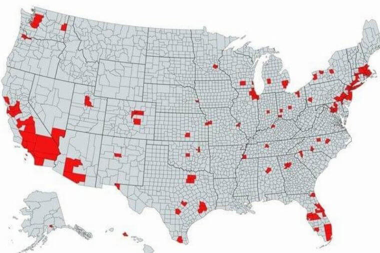
If you look at the 'red' spots on the map, you will notice that most of the population is concentrated on the West and East coasts. The interior is not a hot spot for people to move to. The Midwest is excellent for farming, and if you're interested in leading a quiet life raising livestock and growing crops then that appears to be the place to be.
The Majority Of The Globe's Population
By now, we know which countries are the most populous in the world: China and India. They also happen to be on the same continent, which means much of the world's population is located within the Asia-Pacific region.
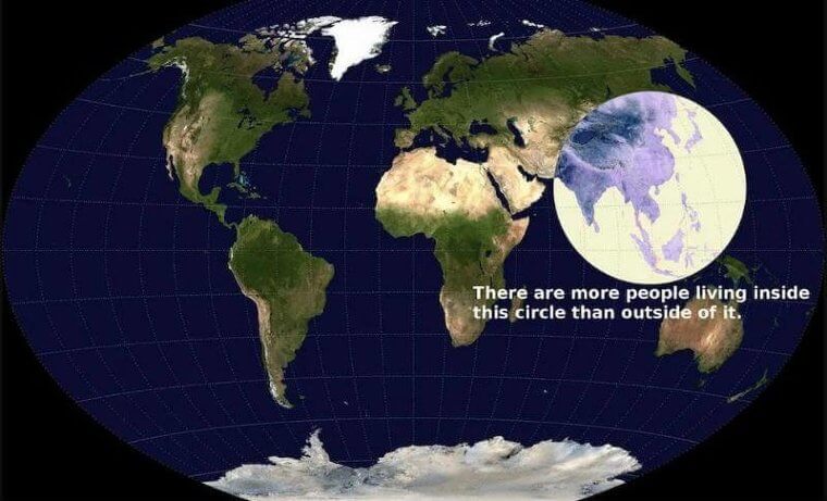
The highlighted circle on this map is where the majority of the world's population resides and it is all in Asia. If you thought the United States was densely populated, then think again. It only accounts for 5 percent of the global population.
--------------------------------------------------
And if you ever wondered where the flamingos of the world hang out, there's a map for that, too.
 = new reply since forum marked as read
Highlight:
NoneDon't highlight anything
5 newestHighlight 5 most recent replies
= new reply since forum marked as read
Highlight:
NoneDon't highlight anything
5 newestHighlight 5 most recent replies

OAITW r.2.0
(32,596 posts)I am surprised that Virginia has no red population counties. The mid-Atlantic coast and Gulf coast counties surprise me as well. The world distribution is pretty amazing, too.

LastDemocratInSC
(4,250 posts)Adjacent to the District of Columbia on the west side.
The 3 counties have a combined population of 2,288,640 residents (2022). That's about 27% of Virginia's total population of 8,679,099 (2022).
There have been rumblings in recent years in the red counties about "evicting" those counties from the state because they are a major factor in all statewide and Federal elections. Having a combined area of 907 square miles they are 2.5% of Virginia's 42,775 square miles.
I say lets create a new state named Nova and get 2 liberal Senators and a bunch of liberal congress members.
OAITW r.2.0
(32,596 posts)I don't think the typical Republican legislator thinks out the long term implications of their legislative efforts.
SWBTATTReg
(26,399 posts)low density all of the way literally to Tulsa/Okla. City (down I-44 West).

ProfessorGAC
(77,270 posts)I've been to England many times.
Road signs are in miles & yards, and I've seen meat & cheese by the pound in supermarkets.
Yet, the "imperial & metric" map shows no red in the U.K.
OAITW r.2.0
(32,596 posts)Professor, where does imperial/metric debate enter this discussion of population distribution?

catbyte
(39,304 posts)the US, Liberia, and Myanmar.
ProfessorGAC
(77,270 posts)It's about one of the other maps in the link.
They're all interesting, but I noticed that oddity.
OAITW r.2.0
(32,596 posts)
ProfessorGAC
(77,270 posts)Oh, and I don't teach language arts. Can you tell? 

Kick in to the DU tip jar?
This week we're running a special pop-up mini fund drive. From Monday through Friday we're going ad-free for all registered members, and we're asking you to kick in to the DU tip jar to support the site and keep us financially healthy.
As a bonus, making a contribution will allow you to leave kudos for another DU member, and at the end of the week we'll recognize the DUers who you think make this community great.