Photography
Related: About this forumShooting the Highest-Resolution Photo Ever Made of Machu Picchu
Shooting the Highest-Resolution Photo Ever Made of Machu Picchu
http://www.petapixel.com/2012/11/16/shooting-the-highest-resolution-photo-ever-created-of-machu-picchu/
Here are a couple of videos by Cremer and Destin of Smarter Every Day, who accompanied Cremer on the trip ...
#!
 = new reply since forum marked as read
Highlight:
NoneDon't highlight anything
5 newestHighlight 5 most recent replies
= new reply since forum marked as read
Highlight:
NoneDon't highlight anything
5 newestHighlight 5 most recent replies

bluedigger
(17,437 posts)You might want to cross post to the Anthropology group - they will like this, too! 
Coyotl
(15,262 posts)Saying the same thing

Callalily
(15,394 posts)
Mira
(22,685 posts)I can vouch for that the high res photos look like the magnificence I saw then with my young eyes.
Upstairs in a closet I have my slides. Probably rotting. You can possibly imagine how many I took.
Other than the obvious of getting to roam there and explore and breathe deeply and learn about the Incas and the phenomenal walls they built with no mortar there are two things I want to tell you.
There is the other mountain, the one that juts up in the photo that starts the little posted video.
http://www.tripadvisor.com/Travel-g294318-d548890/Machu-Picchu eru:Huayna.Picchu.Wayna.Picchu.html
I tried to climb it!
I could not make it. The Urubamba river at the deep down bottom was beckoning for me to fall into it. Some of the turns at the side of the mountain were about 24" wide, you had to grasp the mountain to make it around the bend into the unknown on the other side. I could not do it. They did not have any ropes or anything to help you then. Many fell to their death.
The other thing is I came up in the bus on a switch back road. I called it the Hiram Bingham expressway. Hiram was the explorer who found Machu Picchu in I think 1916.
I was so effin' scared going up I simply cannot describe it. So, instead of going back down on the bus I walked down the entire mountain through the jungle, carrying my suitcase.
I wish I were young again, for just a little while, to do some more really idiotic things like that.
bluedigger
(17,437 posts)Machu Picchu was always on my bucket list. The stairway part reminds me of a photo I've seen of a cantilevered stairway stuck on the side of a vertical wall. 
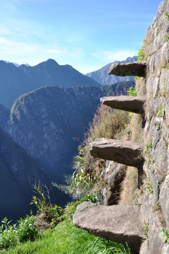
This one?
Mira
(22,685 posts)the grass part where I had to walk and then go around a corner even more narrow than the depiction.
And to my side it would go straight down to the river.
To my right were no steps, just the stone side of the mountain.
I'm getting sick remembering it.
Could not even turn on that ledge, had to inch my way backwards.
Coyotl
(15,262 posts)I was looking it over and it is amazing, on the right side of the terraces near the top in particular. There are cliffs lower down too, with the river on the left instead.
This image is up atop Huaynu Picchu:

13° 9' 28.71" S 72° 32' 48.11" W
Can you find it in the image, Where's this Wall-do?
I like this trail, Inca Bridge:

13° 10' 23.60" S 72° 32' 42.77" W
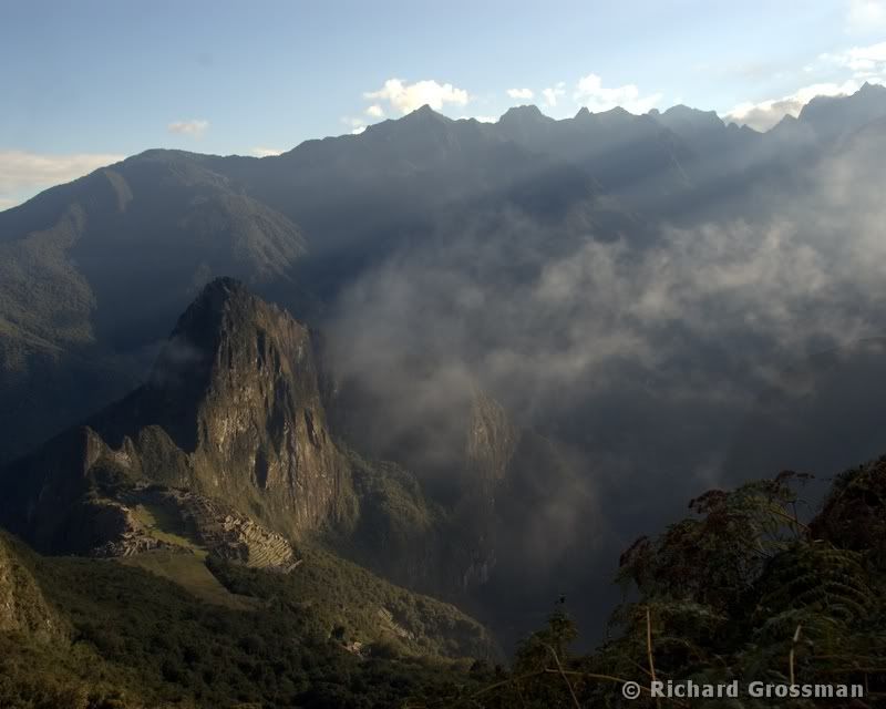
In '88, we walked up in a rain at night, got into the ruins before first light, and photographed the mist rising before the tourists entered the images. In '70, we camped in the agricultural huts near the ruins, staying in for four days. It was a great place to just relax for a few days back then, with far fewer visitors daily.
To descend the mountain, both times I timed the trail run for the buses. You cross in front of them many times, and wave at them again and again as you run down and they slowly zig-zag.
Mira
(22,685 posts)how I went down the mountain perfectly, except I did not time my descent with a bus going down. Just down until I got to cross the road, down, and repeat, over and over.
It's been a real pleasure to have someone know this feeling I had.
I think when the Thanksgiving has quieted down I'll pull out my slides.
Richard D
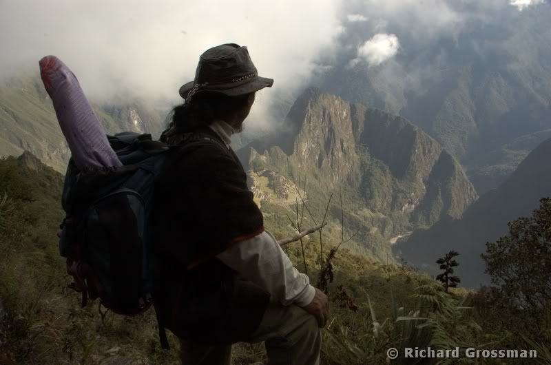
(10,018 posts)And have never had the huevos to climb Huaynu Picchu. I did climb Apu Machupicchu, which is the mountain on which the sanctuary is built. From the top Huaynu Picchu looks fairly small. A hard climb but not scary or dangerous. Quite amazing at the top.
This is on the trail up.
And close to or at the top

Judi Lynn
(164,122 posts)It's a true wonder an entire group of people used these facilities regularly, that they could become so sure-footed, and focused in each step they took living there in order to avoid a complete leap into the abyss.
The staircase photo above looks like science fiction, simply doesn't seem posssible.
Hope many, MANY people will see this thread.
Coyotl
(15,262 posts)None of today's, "Fuck that, let the next guy fix it" culture. These "ruins" survived four plus centuries of utter neglect and look at them still!
Coyotl
(15,262 posts)Last edited Tue Dec 4, 2012, 02:55 PM - Edit history (1)
Looking in the Gigapixel image, I'm impressed by the upper terracing, especially the masonry of the uppermost terrace, and i even see a set of the protruding steps, but not this particular configuration. This image may not be actual, rather a combined spoof. Panoramio may reveal the truth if the three terraces together are found elsewhere. There is some awesome stonework up on that peak!
On edit, I found another photo:

But I still don't confirm in the 16 gigapixel image.

Coyotl
(15,262 posts)I think you can see the rock protruding from the topmost of those three terraces in the 16 gigapixel version. Not the protruding rock:

The end walls not seen here, facing Machu Picchu, are seen from the camera below on their other side.
The lower terrace of the three has brush capping the end and the receding cliff below it.
Look about 9 terraces down from the topmost, all the way to the right. That's the wall-do we want.
On edit, back because I found more photos of same:


The following image has a high-res file here:
http://www.panoramio.com/photo/46170404?source=wapi&referrer=kh.google.com

Richard D
(10,018 posts)Not as scary as it looks. Only a few feet to the ground.
Coyotl
(15,262 posts)according to the image placement in Google Earth. There are others like it in the ruins.
Richard D
(10,018 posts)There's one that looks just like it in the main part of the sanctuary.
I'll be helping to lead another tour there in a few weeks. Pretty excited. It still hasn't gotten old. One of my favorite things is to watch people as they first enter the ruins. The looks on the faces are really precious.
Coyotl
(15,262 posts)Last edited Tue Dec 4, 2012, 01:22 PM - Edit history (1)
if you know how and can do it.
Richard D
(10,018 posts)If so: -13.12572, -72.527153
Coyotl
(15,262 posts)Last edited Tue Dec 4, 2012, 01:24 PM - Edit history (1)
someone with an actual instrument capable of 2m accuracy to do readings of specific points in the ruins, specific huacas like the Intihuatani. The Intihuatani is roped off, so two or more readings equidistant on opposite sides of the position would be required for averaging (or talking nice to the guard in Spanish). Good accuracy requires patience as the instrument takes time to acquire sufficient data. Are you at all familiar with this tasking?
My current Google Earth based coordinate for the Torreon is:
Machu Picchu Torreon
-72.545576 -13.164634
These Google Earth files open a lot of the placemarks determined using Google Earth and some GPS work of undetermined accuracy:
http://jqjacobs.net/archaeo/sites/machu_picchu.kmz
http://jqjacobs.net/archaeo/sites/llactapata.kmz
In Google Earth, turn on the Panoramio layer for tons of images to examine what the positions reference. Google earth has limitations in such vertical terrain due to oblique camera viewing. That oblique angle is seen in this image:

http://jqjacobs.net/archaeo/sites/index.html#africa
"When viewing geometric monuments with significant elevation, the oblique view of the camera is readily apparent—see the Washington Monument.
In this GE screen capture of Khufu's and Khafre's pyramids, note the seam between two images (bright on the right and darker on the left) and note that each pyramid has a unique angle of oblique view.
This points to the degree of accuracy, or I should say "inaccuracy" of the monument representations in this format. Online, an updated image has since replaced this one."
More placemarks of diverse Andes monuments with Panoramio images embedded here:
http://jqjacobs.net/andes/kml/andes_archaeology.kml
Richard D
(10,018 posts)Can it be done with a cell phone? Not sure if there is connection there.
I'll be there in a couple weeks, leading a group. But I will have some free time if it doesn't take too much time to get a good measurement.
Richard D
(10,018 posts)Coyotl
(15,262 posts)because it is not a GPS reading, it is the Google Earth coordinate from the file linked above.
This is a complicated project at graduate level. It requires the correct instrument.
http://g.factoryoutletstore.com/details/2899/garmin-rino-120.html?cid=2967&chid=4272
What is WAAS?
http://www8.garmin.com/aboutGPS/waas.html
Some cameras now embed GPS data to geolocate the camera for each photo, called automatic geotagging.
http://www.amazon.com/Garmin-GPSMAP-62stc-Handheld-Navigator/dp/B0055NQWZO/ref=sr_1_21?s=gps&ie=UTF8&qid=1354670974&sr=1-21
Richard D
(10,018 posts). . I assume that the geo-tagging on my cell phone would not be accurate enough?
Coyotl
(15,262 posts)We are talking a scientific instrument, for geodetic use, that produces and records lat/lon with waas-enabled accuracy of +/- 5m minimum, +/- 2-3m preferred result.
Richard D
(10,018 posts). . . was hoping I could help out.
Mira
(22,685 posts)Richard D
(10,018 posts)I'd love to take all my friends with me! Love, however doesn't pay for plane tickets, etc.
Coyotl
(15,262 posts)since I camped in the ruins in 1970 and revisited in 1988. Your photos may be very different than today. And they just keep working on the place.
Panoramio has innumerable great photos for popular ruins, a great tool for visually learning sites without going there, or to see how they have changed. Googling site:panoramio.com for images also provides coordinates to find places in Google Earth.
Google Earth placemarks with Panoramio images linked:
http://jqjacobs.net/andes/kml/andes_archaeology.kml

SouthernDonkey
(256 posts)You guys and these photos give me chill bumps! It makes me want to go to Peru very badly now! I don't know if I could stand a bus ride back down myself. Thanks for posting!

Stevenmarc
(4,483 posts)Coyotl
(15,262 posts)Mira
(22,685 posts)to my terror when I tried to climb it, and to the beauty of why I wanted to.
Having the mountain TOPS in my line of vision, and looking straight at them or down onto them is a vivid memory. So are the Urubamba river flowing down below, and the road leading up to Machu Picchu. I called it the Hiram Bingham expressway, named it for the guy who discovered it.
Thanks for this!