Welcome to DU!
The truly grassroots left-of-center political community where regular people, not algorithms, drive the discussions and set the standards.
Join the community:
Create a free account
Support DU (and get rid of ads!):
Become a Star Member
Latest Breaking News
Editorials & Other Articles
General Discussion
The DU Lounge
All Forums
Issue Forums
Culture Forums
Alliance Forums
Region Forums
Support Forums
Help & Search
North Carolina
Related: About this forumShale AND Water
http://www.geology.enr.state.nc.us/Mineral%20resources/Mineral_Resources.htmlPetroleum and natural gas - Approximately 125 exploratory oil and gas wells have been drilled in North Carolina since the first one was drilled in 1925. Most have been in the outer Coastal Plain. Traces of oil and gas have been detected in a few of these wells but no producing wells have been developed.
Several areas in North Carolina are considered to have potential to produce oil and gas. The main area is the outer Coastal Plain. It contains a relatively thick pile of sedimentary rocks including some excellent trap or reservoir rocks, but source rocks may not be present.
Seismic surveys in the Blue Ridge suggest that sedimentary rocks are deep beneath the crystalline rocks. These sediments may be similar to oil- and gas-bearing sediments in the Valley and Ridge Province. Detailed studies have not been conducted to verify the seismic surveys.
The Triassic basins have received attention from oil and gas exploration companies during recent years. Excellent source rocks are present, but the sandstones are not permeable. Fine-grained material fills pore spaces between the sand grains, preventing the migration of hydrocarbons. The Cumnock and Gulf coal beds* have been studies for possible in-situ methane gas generation.
Mobil Oil Corporation proposed to drill for natural gas of the Atlantic shelf off the North Carolina coast.
http://nc.water.usgs.gov/projects/shalegas/
http://nc.water.usgs.gov/projects/shalegas/overview.html

http://nc.water.usgs.gov/projects/shalegas/news.html

Introduction
Simpson well. Photo by Jeff Reid, North Carolina Geological Survey
The U.S. Geological Survey (USGS) North Carolina Water Science Center is conducting an inventory of well records and baseline groundwater-quality sampling to better delineate areas of groundwater use and groundwater-quality characteristics prior to potential shale gas exploration in the Triassic Basins of Lee and Chatham Counties, North Carolina (fig. 1). Shale Gas exploration has become economically viable in many areas of the United States (http://www.eia.doe.gov/oil_gas/rpd/shaleusa2.pdf) as a result of improved directional drilling capabilities and hydraulic fracturing ("fracking"techniques. The compilation of baseline groundwater-quality data in North Carolina is an opportunity for comparison to data collected after drilling activities commence should the State allow Shale Gas exploration to occur.
In June 2011, the North Carolina Legislature passed House Bill 242 directing the North Carolina Department of Environment and Natural Resources (NC DENR) to study issues related to potential Shale Gas Exploration in the Triassic Basins of the State (http://www.ncleg.net/sessions/2011/bills/house/pdf/h242v2.pdf).
Project Summary
Problem
Drilling processes and waste disposal practices related to shale gas exploration in the United States and other parts of the world has sometimes led to contamination of groundwater resources. Interest in the Triassic Basin shale deposits in North Carolina has grown in recent years as more than 9,000 acres have been leased within the Sanford sub-basin (fig. 1) study area in parts of Lee and Chatham counties. Baseline/reconnaissance groundwater-quality samples will be collected from private, community, and non-community transient wells in the Sanford sub-basin study area ahead of shale gas exploration in the State. These data may be used for comparison to post-drilling/hydraulic fracturing groundwater-quality data from this area should any effects from the drilling process become a concern at a later time.
Publications
Related References
http://nc.water.usgs.gov/projects/shalegas/pubs.html
http://water.usgs.gov/
http://waterwatch.usgs.gov/?id=ww_past
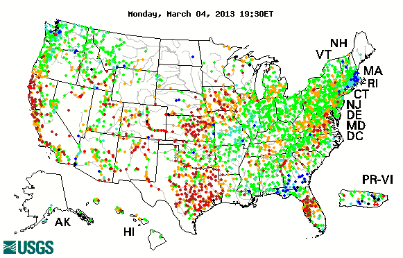
WaterWatch (http://waterwatch.usgs.gov) is a U.S. Geological Survey (USGS) World Wide Web site that displays maps, graphs, and tables describing real-time, recent, and past streamflow conditions for the United States. The real-time information generally is updated on an hourly basis. WaterWatch provides streamgage-based maps that show the location of more than 3,000 long-term (30 years or more) USGS streamgages; use colors to represent streamflow conditions compared to historical streamflow; feature a point-and-click interface allowing users to retrieve graphs of stream stage (water elevation) and flow; and highlight locations where extreme hydrologic events, such as floods and droughts, are occurring.
Streamflow Map

*http://www.pdhsc.com/egypt_coal_mine.htm
http://freepages.history.rootsweb.ancestry.com/~pfwilson/historical_timeline.html
http://www.learnnc.org/lp/editions/nchist-newcentury/6008
http://www.lib.unc.edu/ncc/ref/nchistory/may2005/index.html
http://www3.gendisasters.com/north-carolina/19732/cumnock-nc-coal-mine-explosion-may-1900
4 replies
 = new reply since forum marked as read
Highlight:
NoneDon't highlight anything
5 newestHighlight 5 most recent replies
Shale AND Water (Original Post)
littlemissmartypants
Mar 2013
OP
In_The_Wind
(72,300 posts)1. Is there a petition to protest this?
If not. Why not start one?
mmonk
(52,589 posts)2. Good work.
littlemissmartypants
(32,806 posts)3. Back to you & Thank you. My question is where are the results?
These data may be used for comparison to post-drilling/hydraulic fracturing groundwater-quality data from this area should any effects from the drilling process become a concern at a later time.
I am a scientist. I want to see the data. Do you think we can get a copy?
Love, Peace and Shelter.
lmsp
mmonk
(52,589 posts)4. Maybe from the state geologist.
Good question.


