Welcome to DU!
The truly grassroots left-of-center political community where regular people, not algorithms, drive the discussions and set the standards.
Join the community:
Create a free account
Support DU (and get rid of ads!):
Become a Star Member
Latest Breaking News
Editorials & Other Articles
General Discussion
The DU Lounge
All Forums
Issue Forums
Culture Forums
Alliance Forums
Region Forums
Support Forums
Help & Search
Pennsylvania
Related: About this forumOn this day, July 21, 2003, the Kinzua Viaduct was destroyed by a tornado.
Wed Jul 21, 2021: On this day, July 21, 2003, the Kinzua Viaduct was destroyed by a tornado.
Sun Jul 21, 2019: July 21, 2003: Kinzua Viaduct destroyed by tornado
Sat Jul 22, 2017: Tough luck, 14 years and one day ago, Kinzua Viaduct
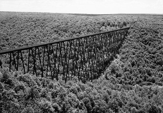
I'm a big fan of railroad bridges and tunnels. I walked across quite a few bridges and through many tunnels. I first saw this bridge in October 1975. It was really an engineering marvel.
Back then, you could walk across it. I did just that. On that day, it looked just as it does in the first picture.
Kinzua Viaduct

The bridge before its collapse
Coordinates: 41°45′40″N 78°35′19″W
The Kinzua Bridge or the Kinzua Viaduct (/ˈkɪnzuː/,[2] /-zuːə/) was a railroad trestle that spanned Kinzua Creek in McKean County in the U.S. state of Pennsylvania. The bridge was 301 feet (92 m) tall and 2,052 feet (625 m) long. Most of its structure collapsed during a tornado in 2003.
The bridge was originally built from wrought iron in 1882 and was billed as the "Eighth Wonder of the World", holding the record as the tallest railroad bridge in the world for two years. In 1900, the bridge was dismantled and simultaneously rebuilt out of steel to allow it to accommodate heavier trains. It stayed in commercial service until 1959 and was sold to the Government of Pennsylvania in 1963, becoming the centerpiece of a state park. Restoration of the bridge began in 2002, but before it was finished, a tornado struck the bridge in 2003, causing a large portion of the bridge to collapse. Corroded anchor bolts holding the bridge to its foundations failed, contributing to the collapse.
Before its collapse, the Kinzua Bridge was ranked as the fourth-tallest railway bridge in the United States. It was listed on the National Register of Historic Places in 1977 and as a National Historic Civil Engineering Landmark in 1982. The ruins of the Kinzua Bridge are in Kinzua Bridge State Park off U.S. Route 6 near the borough of Mount Jewett, Pennsylvania.
{snip}
Historic American Engineering Record (HAER) photo of the bridge in July 1971
{The picture is by Jack Boucher.}
{snip}
Destruction
Since 2002, the Kinzua Bridge had been closed to all "recreational pedestrian and railroad usage" after it was determined that the structure was at risk to high winds. Engineers had determined that during high winds, the bridge's center of gravity could shift, putting weight onto only one side of the bridge and causing it to fail. An Ohio-based bridge construction and repair company had already started work on restoring the Kinzua Bridge in February 2003.
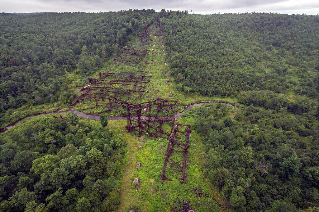
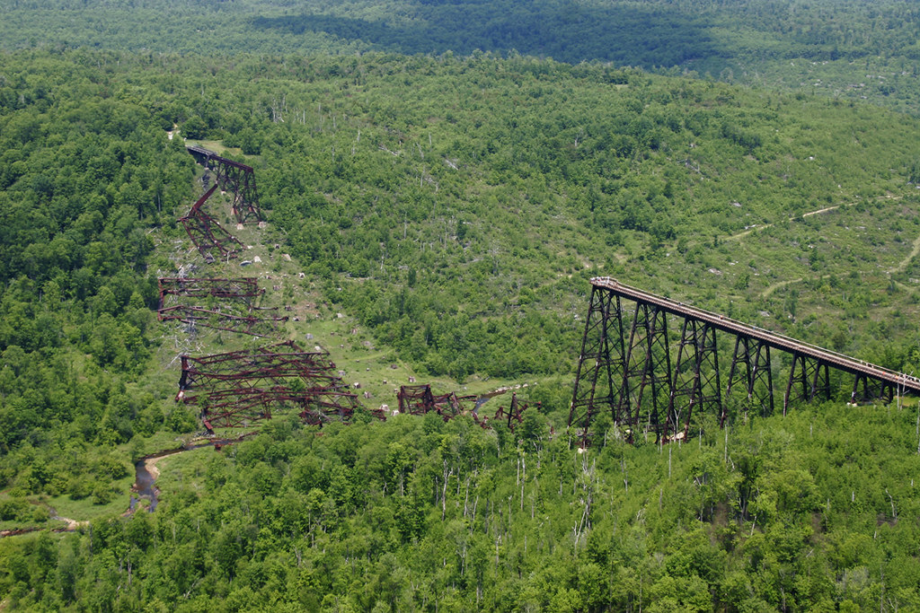
On July 21, 2003, construction workers had already packed up and were starting to leave for the day when a storm arrived. A tornado within the storm struck the Kinzua Bridge, snapping and uprooting nearby trees, as well as causing 11 of the 20 bridge towers to collapse. There were no human deaths or injuries. The tornado was produced by a mesoscale convective system (MCS), a complex of strong thunderstorms, that had formed over an area that included eastern Ohio, western Pennsylvania, western New York, and southern Ontario. The MCS traveled east at around 40 miles per hour (60 km/h). As the MCS crossed northwestern Pennsylvania, it formed into a distinctive comma shape. The northern portion of the MCS contained a long-lived mesocyclone, a thunderstorm with a rotating updraft that is often conducive to tornados. (31)
At approximately 15:20 EDT (19:20 UTC), the tornado touched down in Kinzua Bridge State Park, 1 mile (1.6 km) from the Kinzua Bridge. The tornado, classified as F1 on the Fujita scale, passed by the bridge and continued another 2.5 miles (4.0 km) before it lifted. It touched down again 2 miles (3 km) from Smethport and traveled another 3 miles (5 km) before finally dissipating. It was estimated to have been 1⁄3-mile (0.5 km) wide and it left a path 3.5 miles (5.6 km) long. The same storm also spawned an F3 tornado in nearby Potter County.
When the tornado touched down, the winds had increased to at least 94 miles per hour (151 km/h) and were coming from the east, perpendicular to the bridge, which ran north–south. An investigation determined that Towers 10 and 11 had collapsed first, in a westerly direction. Meanwhile, Towers 12 through 14 had actually been picked up off of their foundations, moved slightly to the northwest and set back down intact and upright, held together by only the railroad tracks on the bridge. Next towers four through nine collapsed to the west, twisting clockwise, as the tornado started to move northward. As it moved north, inflow winds came in from the south and caused Towers 12, 13, and 14 to finally collapse towards the north, twisting counterclockwise.
The failures were caused by the badly rusted base bolts holding the bases of the towers to concrete anchor blocks embedded into the ground. An investigation determined that the tornado had a wind speed of at least 94 miles per hour (151 km/h), which applied an estimated 90 short tons-force (800 kN) of lateral force against the bridge. (35) The investigation also hypothesized that the whole structure oscillated laterally four to five times before fatigue started to cause the base bolts to fail. The towers fell intact in sections and suffered damage upon impact with the ground. The century-old bridge was destroyed in less than 30 seconds.
{snip}
(31) https://web.archive.org/web/20120922031605/http://www.dcnr.state.pa.us/info/kinzuabridgereport/app/appb.pdf
(35) https://web.archive.org/web/20110609093002/http://www.dcnr.state.pa.us/info/kinzuabridgereport/body/009.html
The bridge before its collapse
Coordinates: 41°45′40″N 78°35′19″W
The Kinzua Bridge or the Kinzua Viaduct (/ˈkɪnzuː/,[2] /-zuːə/) was a railroad trestle that spanned Kinzua Creek in McKean County in the U.S. state of Pennsylvania. The bridge was 301 feet (92 m) tall and 2,052 feet (625 m) long. Most of its structure collapsed during a tornado in 2003.
The bridge was originally built from wrought iron in 1882 and was billed as the "Eighth Wonder of the World", holding the record as the tallest railroad bridge in the world for two years. In 1900, the bridge was dismantled and simultaneously rebuilt out of steel to allow it to accommodate heavier trains. It stayed in commercial service until 1959 and was sold to the Government of Pennsylvania in 1963, becoming the centerpiece of a state park. Restoration of the bridge began in 2002, but before it was finished, a tornado struck the bridge in 2003, causing a large portion of the bridge to collapse. Corroded anchor bolts holding the bridge to its foundations failed, contributing to the collapse.
Before its collapse, the Kinzua Bridge was ranked as the fourth-tallest railway bridge in the United States. It was listed on the National Register of Historic Places in 1977 and as a National Historic Civil Engineering Landmark in 1982. The ruins of the Kinzua Bridge are in Kinzua Bridge State Park off U.S. Route 6 near the borough of Mount Jewett, Pennsylvania.
{snip}
Historic American Engineering Record (HAER) photo of the bridge in July 1971
{The picture is by Jack Boucher.}
{snip}
Destruction
Since 2002, the Kinzua Bridge had been closed to all "recreational pedestrian and railroad usage" after it was determined that the structure was at risk to high winds. Engineers had determined that during high winds, the bridge's center of gravity could shift, putting weight onto only one side of the bridge and causing it to fail. An Ohio-based bridge construction and repair company had already started work on restoring the Kinzua Bridge in February 2003.
On July 21, 2003, construction workers had already packed up and were starting to leave for the day when a storm arrived. A tornado within the storm struck the Kinzua Bridge, snapping and uprooting nearby trees, as well as causing 11 of the 20 bridge towers to collapse. There were no human deaths or injuries. The tornado was produced by a mesoscale convective system (MCS), a complex of strong thunderstorms, that had formed over an area that included eastern Ohio, western Pennsylvania, western New York, and southern Ontario. The MCS traveled east at around 40 miles per hour (60 km/h). As the MCS crossed northwestern Pennsylvania, it formed into a distinctive comma shape. The northern portion of the MCS contained a long-lived mesocyclone, a thunderstorm with a rotating updraft that is often conducive to tornados. (31)
At approximately 15:20 EDT (19:20 UTC), the tornado touched down in Kinzua Bridge State Park, 1 mile (1.6 km) from the Kinzua Bridge. The tornado, classified as F1 on the Fujita scale, passed by the bridge and continued another 2.5 miles (4.0 km) before it lifted. It touched down again 2 miles (3 km) from Smethport and traveled another 3 miles (5 km) before finally dissipating. It was estimated to have been 1⁄3-mile (0.5 km) wide and it left a path 3.5 miles (5.6 km) long. The same storm also spawned an F3 tornado in nearby Potter County.
When the tornado touched down, the winds had increased to at least 94 miles per hour (151 km/h) and were coming from the east, perpendicular to the bridge, which ran north–south. An investigation determined that Towers 10 and 11 had collapsed first, in a westerly direction. Meanwhile, Towers 12 through 14 had actually been picked up off of their foundations, moved slightly to the northwest and set back down intact and upright, held together by only the railroad tracks on the bridge. Next towers four through nine collapsed to the west, twisting clockwise, as the tornado started to move northward. As it moved north, inflow winds came in from the south and caused Towers 12, 13, and 14 to finally collapse towards the north, twisting counterclockwise.
The failures were caused by the badly rusted base bolts holding the bases of the towers to concrete anchor blocks embedded into the ground. An investigation determined that the tornado had a wind speed of at least 94 miles per hour (151 km/h), which applied an estimated 90 short tons-force (800 kN) of lateral force against the bridge. (35) The investigation also hypothesized that the whole structure oscillated laterally four to five times before fatigue started to cause the base bolts to fail. The towers fell intact in sections and suffered damage upon impact with the ground. The century-old bridge was destroyed in less than 30 seconds.
{snip}
(31) https://web.archive.org/web/20120922031605/http://www.dcnr.state.pa.us/info/kinzuabridgereport/app/appb.pdf
(35) https://web.archive.org/web/20110609093002/http://www.dcnr.state.pa.us/info/kinzuabridgereport/body/009.html
The tornado made a direct hit. This is what the bridge looked like after it collapsed:
In this view, you're looking almost due north:
This is looking to the northeast:

1 replies
 = new reply since forum marked as read
Highlight:
NoneDon't highlight anything
5 newestHighlight 5 most recent replies
= new reply since forum marked as read
Highlight:
NoneDon't highlight anything
5 newestHighlight 5 most recent replies
= new reply since forum marked as read
Highlight:
NoneDon't highlight anything
5 newestHighlight 5 most recent replies
On this day, July 21, 2003, the Kinzua Viaduct was destroyed by a tornado. (Original Post)
mahatmakanejeeves
Jul 2022
OP

FakeNoose
(40,759 posts)1. I don't live near there, but I remember when it happened
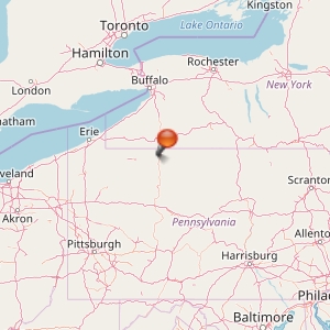
This map shows the location of Kinzua Bridge State Park, in northwestern Pennsylvania. It's sort of wild and remote up there and the weather is wilder too. They get the same lake-effect storms that hit Erie and Buffalo.
I don't think that train runs any more, does it?
