Latin America
Related: About this forumScientists Found a Mind-Blowing Mayan Civilization Buried in Plain Sight
They used lasers to make the stunning discovery.
BY TIM NEWCOMB
PUBLISHED: MAR 15, 2023
Ancient Mesoamerica
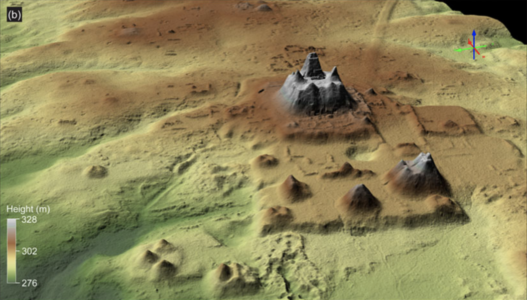
In a new study published in the journal Ancient Mesoamerica, researchers from Texas-based universities used LiDAR, or laser-based imaging, to open up more of Maya settlement history than ever known before.
The light detection and ranging technology pierced through the heavily forested Mirador-Calakmul Karst Basin in northern Guatemala to show that more than 1,000 settlements covered about 650 square miles, all connected with 110 miles of causeways that the Maya people used to travel their settlements, cities, and cultural centers. The researchers even located canals and reservoirs, highlighting the expanse of the organization from the Maya culture in the middle and late preclassic period from about 1000 BC to 150 AD.
It all amounted to a first look at "an area that was integrated politically and economically, and never seen before in other places in the Western Hemisphere," study co-author Carlos Morales-Aguilar, of the Department of Geography and the Environment at the University of Texas at Austin, tells Live Science. "We can now see the entire landscape of the Maya region."
The concentration of preclassic Maya sites connected by causeways forms a "web of implied social, political, and economic interactions," according to the study:
"Monumental architecture, consistent architectural formats, specific site boundaries, water management/collection facilities, and 177 kilometers (110 miles) of elevated preclassic causeways suggest labor investments that defy organizational capabilities of lesser polities and potentially portray the strategies of governance in the preclassic period."
More:
https://www.popularmechanics.com/science/archaeology/a43328150/scientists-find-hidden-mayan-civilization/
(Surely hope they can uncover some of this amazing city in our lifetimes...)

 = new reply since forum marked as read
Highlight:
NoneDon't highlight anything
5 newestHighlight 5 most recent replies
= new reply since forum marked as read
Highlight:
NoneDon't highlight anything
5 newestHighlight 5 most recent replies

riversedge
(80,062 posts)
2naSalit
(101,039 posts)For archaeology, among other scientific genres. It was just coming into use when I was in grad school, my interface with it was environmental analyses but, having a BA in anthropology, I saw the potential for this sort of application.
I would like to see how the more recent findings of structure communities align with the proposed timelines and analyses presented in the book, 1491. I can imagine a good part of the new information could validate those theories. Every time I see these articles of new archaeological sites in the Americas, I wonder about whether there are collaborative findings.
Fascinating. Thanks for posting all of these bits of info. 

Pobeka
(5,000 posts)I was heavily involved with lidar use in the Pacific Northwest, where the forest cover is exceptionally dense, making it very difficult for a laser shot to make it all the way to the ground.
Having travelled to the Yucatan a couple of times as a tourist, what I saw of the native "forest" there, if you could call it that, was very open, and lidar would've been exceptional at getting all the way to the ground on a large number of laser shots. It's those ground shots that give the good view of old structures.
I don't know how open the native forests are as you travel further south towards Guatemala, Belize etc...
2naSalit
(101,039 posts)The forests/jungles can be pretty dense in some parts. I can see where density might be a barrier for LiDAR but it seems to be pretty useful where applied.