NSIDC: Bottom Falls Out Of Arctic, Antarctic Sea Ice Graphs For November; 5.7 SD South, 3.2 SD North
EDIT
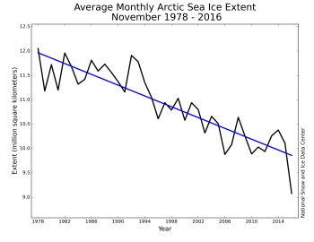
Figure 3. Monthly November ice extent for 1979 to 2016 shows a decline of 5.0 percent per decade.
In November 2016, Arctic sea ice extent averaged 9.08 million square kilometers (3.51 million square miles), the lowest November in the satellite record. This is 800,000 square kilometers (309,000 square miles) below November 2006, the previous lowest November, and 1.95 million square kilometers (753,000 square miles) below the 1981 to 2010 long-term average for November. For the month, ice extent was 3.2 standard deviations below the long-term average, a larger departure than observed in September 2012 when the Arctic summer minimum extent hit a record low.
At this time of year, air temperatures near the surface of the Arctic Ocean are generally well below freezing, but this year has seen exceptional warmth. The overall rate of ice growth this November was 88,000 square kilometers (34,000 square miles) per day, a bit faster than the long-term average of 69,600 square kilometers (26,900 square miles) per day. However, for a brief period in the middle the month, total extent actually decreased by 50,000 square kilometers, or 19,300 square miles—an almost unprecedented occurrence for November over the period of satellite observations. A less pronounced and brief retreat of 14,000 square kilometers (5,400 square miles) occurred in 2013.
Ice growth during November as a whole occurred primarily within the Beaufort, Chukchi and East Siberian Seas, as well as within Baffin Bay. Ice extent slightly retreated in the Barents Sea for the month. Compared to the previous record low for the month set in 2006, sea ice was less extensive in the Kara, Barents, East Greenland, and Chukchi Seas, and more extensive in Baffin Bay this year.
EDIT
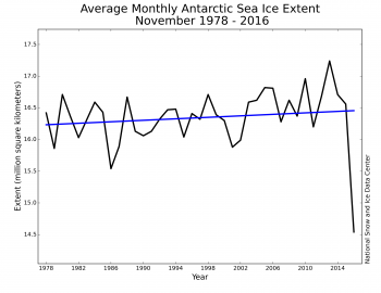
Figure 5a. Monthly November Antarctic sea ice extent for 1979 to 2016 shows an increase of 0.36 percent per decade.
This year, Antarctic sea ice reached its annual maximum extent on August 31, much earlier than average, and has since been declining at a fairly rapid pace, tracking more than two standard deviations below the 1981 to 2010 average. This led to a new record low for the month of November over the period of satellite observations (Figure 5a). Average extent in November was 14.54 million square kilometers (5.61 million square miles). This was 1.0 million square kilometers (386,000 square miles) below the previous record low of 15.54 million square kilometers (6.00 million square miles) set in 1986 and 1.81 million square kilometers (699,000 square miles) below the 1981 to 2010 average.
For the month, Antarctic ice extent was 5.7 standard deviations below the long-term average. This departure from average was more than twice as large as the previous record departure from average, set in November 1986.
EDIT
http://nsidc.org/arcticseaicenews/
