2nd-Earliest Start To Greenland Melt Season In 39 Years Of Instrumental Records
Today DMI scientists announced the start of the Greenland melt season, the second earliest in a record that stretches back to 1980. “The start of the melt season occurs on the first of three consecutive days where more than 5% of the ice sheet has melt at the surface.” said scientist Peter Langen. “We use a pretty strict definition as we want to make sure it is a consistent start to melting and not just a blip due to unseasonal weather”. This year’s start of 30th April is second only to 2016, when a very unusual weather pattern caused a very early start to the melt season in mid-April.
“On average, the melt season starts around the 26th May, so we are almost a full month earlier this year” he continued. Number three on the list is 2nd May 2010 when a similar weather pattern also caused early melt onset closely followed by 2017 on the 7th May, the top four have all occurred within the last ten years.
However, weather patterns in the North Atlantic are important for controlling how early melt gets going, 2015 for example was the 3rd latest start to melting in the record after late snowfalls in spring reduced melting and joint 5th place on the list is 2006 and 1990.
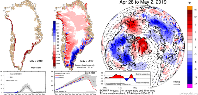
The early melt onset (left), red shows areas where melting is occurring. Centre: the dry winter over most of Greenland compared to normal is shown in red, the blue area shows places where more snow than usual has fallen since 1st September 2018. Warmer than usual air over Greenland, Baffin Bay and the central Arctic is visible in red (right), the North Atlantic Oscillation is shown in the graph underneath. “This winter a persistently positive north Atlantic Oscillation – the weather pattern that also largely controls how cold and wet northern European winters are has led to a generally dry and cold winter in Greenland” said climate scientist Martin Stendel. “IN many ways Europe and Greenland have opposite weather patterns, a mild wet winter in europe often means a relatively cold and dry winter in Greenland”.
EDIT
http://polarportal.dk/nyheder/nyheder/greenland-melt-season-officially-starts-almost-a-month-early/?fbclid=IwAR2ZSLRNHGUrZsfgEoEGbCMVW2ojH8X-bFbQLoDuYI9XBjHigJGYP3LKJe8
