Cyclone Amphan Went From Minimal TS To Cat 5 In 48 Hrs; Heading For Bangladesh, E. India
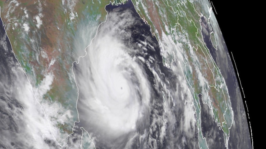
After a spectacular bout of rapid intensification on Sunday, Tropical Cyclone Amphan poses a grave storm-surge threat to the highly vulnerable coastline of the upper Bay of Bengal. The Joint Typhoon Warning Center (JTWC) upgraded Amphan to the equivalent of Category 5 strength at 2 am EDT Monday, with top 1-minute sustained winds estimated at 140 knots (160 mph).
On the scale used by the Indian Meteorological Department (IMD), Amphan was upgraded at 3 am EDT Monday to the highest possible level: super cyclonic storm. Only a handful of storms—about one per decade—achieve this level, which corresponds to a three-minute-averaged wind speed of 120 knots (140 mph). Hurricane ratings by the National Hurricane Center and JTWC are based on one-minute averaging, which will yield higher wind speeds for a given storm.
Amphan took advantage of very favorable conditions in the southern Bay of Bengal to strengthen incredibly quickly over the weekend. Drawing on very warm sea surface temperatures of 31°C (88°F), high oceanic heat content, and light wind shear, Amphan bolted from minimal tropical storm strength (35 knots or 40 mph) to Category 5 equivalent strength (140 knots or 160 mph) in just 48 hours—and from minimal hurricane strength (65 knots or 75 mph) to Cat 5 equivalent strength in just 24 hours.
Forecast for Amphan: Some weakening possible before landfall, but storm surge threat will remain dire
Steering currents are expected to take Amphan on a straightforward track just east of due north. On this course, Amphan will likely make landfall somewhere between Kolkata, India, and Chittagong, Bangladesh, on Wednesday morning local time. Even as Amphan reached Category 5 strength, there were already signs of a potential eyewall replacement cycle brewing. Such a process would halt Amphan’s strengthening and perhaps weaken it slightly. As it moves into the northern Bay of Bengal on Tuesday local time, wind shear will ramp up from around 10 knots to 20-25 knots, and the shear will inject somewhat drier air into the storm. All these factors imply that Amphan may decline gradually in strength before it plows ashore, although perhaps not by as much as the JTWC’s 09Z Monday forecast that Amphan will be a Category 1 storm when it makes landfall. The 00Z Monday run of the high-resolution HWRF model, one of the best models at storm intensity, projects that Amphan will maintain Category 4 strength up through landfall.
EDIT
Some of the most destructive and deadly cyclones in world history have struck the northern Bay of Bengal. An 1876 cyclone brought the highest known storm surge to Bangladesh—13.0 meters (43 feet). The mighty cyclone killed an estimated 200,000 people. The deadliest storm in world history, the 1970 Bhola Cyclone of 1970, killed an estimated 300,000 – 500,000 when it made landfall in Bangladesh along the Meghna River Estuary near Bhola Island on November 12, 1970. The cyclone brought a storm surge estimated at 10.4 meters (34 feet) to the coast.
EDIT
https://www.wunderground.com/cat6/category-5-amphan-to-send-massive-storm-surge-into-eastern-india-and-bangladesh
