Welcome to DU!
The truly grassroots left-of-center political community where regular people, not algorithms, drive the discussions and set the standards.
Join the community:
Create a free account
Support DU (and get rid of ads!):
Become a Star Member
Latest Breaking News
Editorials & Other Articles
General Discussion
The DU Lounge
All Forums
Issue Forums
Culture Forums
Alliance Forums
Region Forums
Support Forums
Help & Search
Environment & Energy
Related: About this forumInteresting Video Of Lake Powell Silt Delta (Colorado Arm)
This about nine miles downstream from the since-abandoned Hite Marina, and about 12 miles down from the Dirty Devil/Colorado confluence. The hydrologists think the delta in this area is between 100 and 150' deep.

4 replies
 = new reply since forum marked as read
Highlight:
NoneDon't highlight anything
5 newestHighlight 5 most recent replies
= new reply since forum marked as read
Highlight:
NoneDon't highlight anything
5 newestHighlight 5 most recent replies
= new reply since forum marked as read
Highlight:
NoneDon't highlight anything
5 newestHighlight 5 most recent replies
Interesting Video Of Lake Powell Silt Delta (Colorado Arm) (Original Post)
hatrack
Oct 2021
OP

Random Boomer
(4,393 posts)1. Fair warning about the video
There is next to no narration, and zippo context for what is being filmed. I assume that people with more knowledge than I have will understand what they're looking at here, but I had no clue what any of it meant. Lots of water, some land, more water.

hatrack
(64,527 posts)2. Good point - what AM I looking at here? I forget not everybody's a subject matter geek like me . .
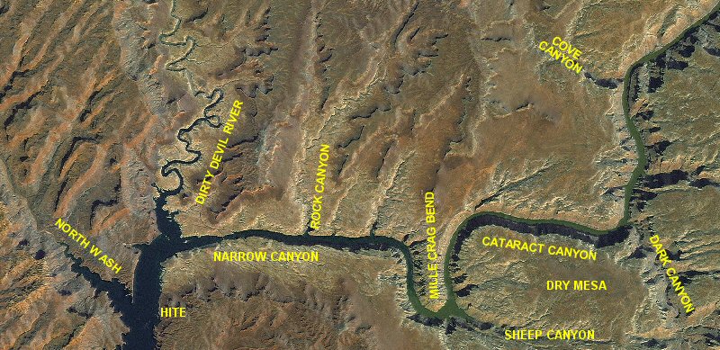
Anyway, the video shows the results of 60 years of sedimentation that the drought has revealed.
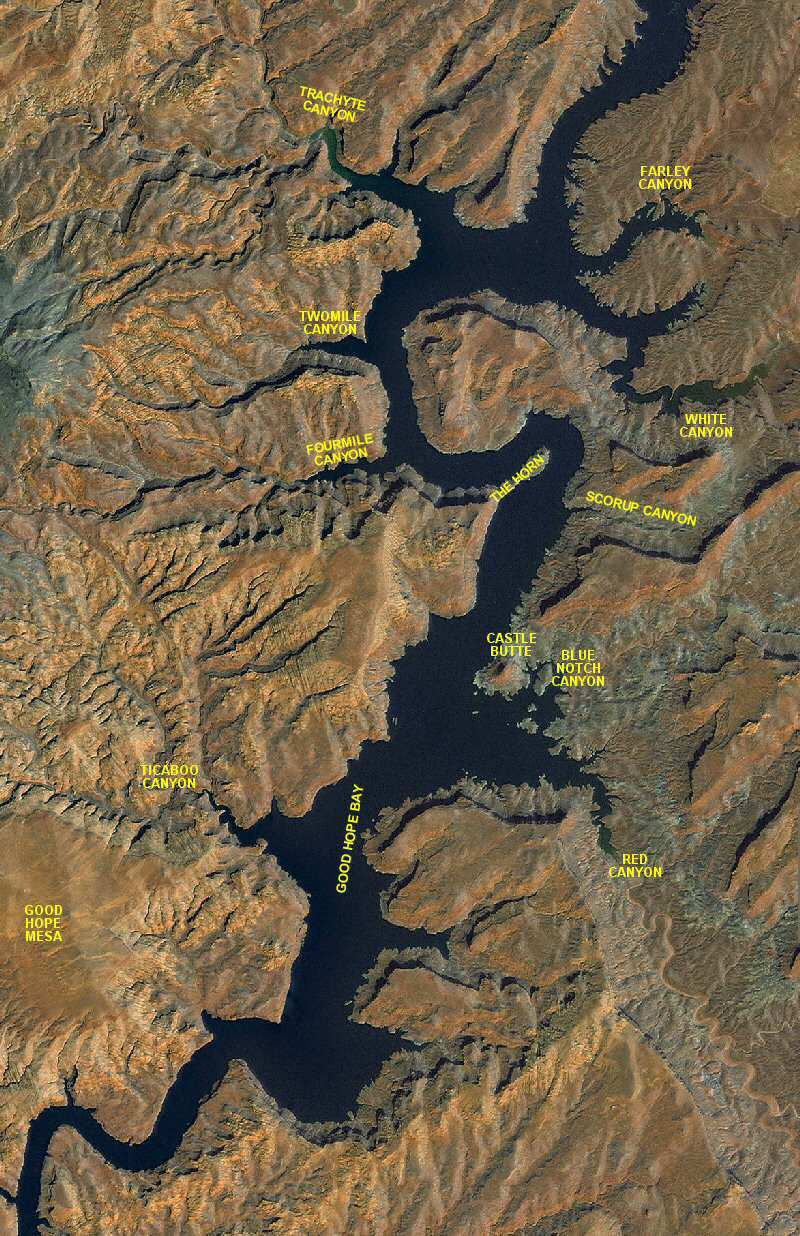
The two maps above flow continuously into each other, and the video was taken just upstream of Four Mile Canyon, which is on the second map, at the toe of the silt delta.
Since the diversion tunnel gates closed on Glen Canyon Dam in 1963, the Colorado River has been doing what it's been doing for millions of years - carrying silt and debris and mud downstream. A rough estimate for the Colorado is 1,400 shipping containers per day deposited in Powell, though that average encompasses flash floods and seasonal peak flows.
That sediment is now pushing its way inexorably down the reservoir from north to south, making passage upstream from the delta impossible except for kayaks and rafts. It's also permanently displacing storage capacity from the reservoir and "Hite", marked on the map, is a marina which closed almost 20 years ago. It's now inaccesible, marooned in a canyon of mud.
Beyond that, the issue isn't just regular flows of sediment carried by the river. When the reservoir was full, it reached all the way up the Colorado to the border of Canyonlands NP. During the decades when the lake was full, or close to full, all that sediment fell out. As a result, when you travel down Cataract Canyon today, for about 30 miles above the reservoir, the river is lined with mud banks that grow in height as you move downstream - 15, 20, sometimes 25 feet in height - millions and millions of cubic yards of it. That sediment is perched, waiting to move downstream with the next spring rise or flash flood, adding its load to the sediment already in transit.
This is one of those classic "Well, we'll deal with this later" problems that didn't get a lot of attention back in the 20th Century when we were going hell-for-leather on building dams. This is the "later" part and it's not going away.
Random Boomer
(4,393 posts)3. Thank you!
Your in-depth explanation provided the context I was missing. Very helpful!

hunter
(40,487 posts)4. Once again we built a giant ticking time bomb and left it for future generations to defuse.
Unfortunately if global warming destroys this civilization these future generations will have no ability to solve the problem.
If human society is reduced to a hand cart and pick-ax level of technology it's not hard to imagine a cascade failure of the dams along the Colorado River.
The Glen Canyon dam has already come close to failing once.
https://en.wikipedia.org/wiki/Risks_to_the_Glen_Canyon_Dam