Environment & Energy
Related: About this forumSubmerged Since 1969, One Of America's Biggest Natural Bridges Emerges As Powell Recedes
 ?resize=1200%2C801
Gregory Natural Bridge, resurfaced for the first time in almost 60 years.
len Canyon is revealing itself.
David Brower, the first executive director of the Sierra Club and a three-time Nobel Peace Prize nominee, once said flooding Glen Canyon would be “America’s most regretted environmental mistake." But almost 60 years after the fact, the full extent of that "mistake" remains mysterious.
Archaeologists and naturalists hastened to detail the canyon’s contents even as the Glen Canyon Dam was under construction. By the time the waters of Lake Powell began to rise in 1963, their photos and notebooks salvaged accounts of petroglyphs, natural bridges and extensive, pristine ecosystems in the Glen Canyon area. But their work was far from complete. They documented just enough to guess at the grand total of what would be drowned under Lake Powell. William Lipe, one of the leading archaeologists of this effort, reflected that “there was an awareness that a lot was being lost.” Now, long-term drought has brought water levels in Lake Powell to historic lows. As the shores recede, they unveil Glen Canyon’s lost wonders, allowing the consequences to resurface.
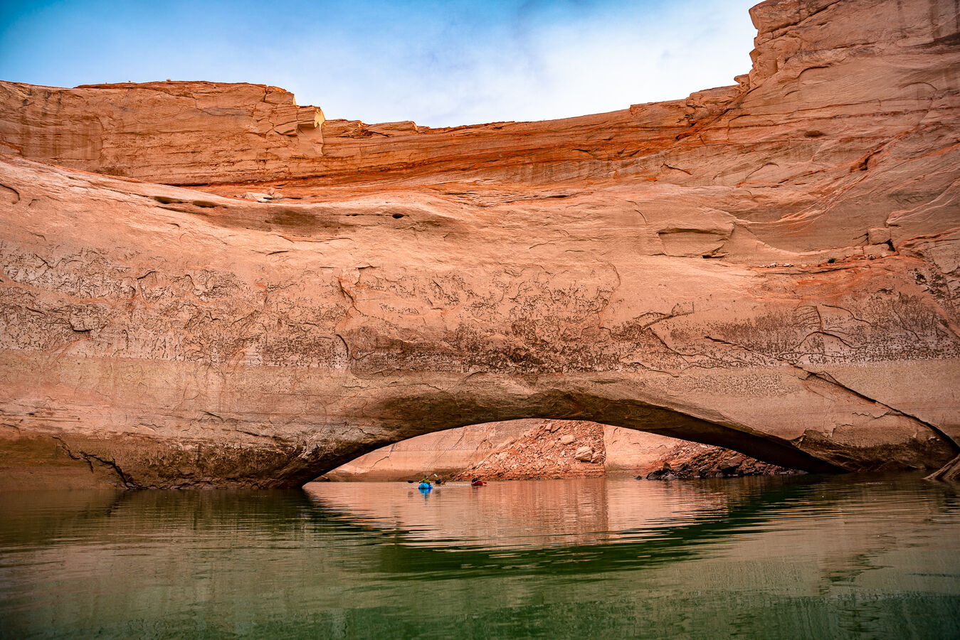
Gregory Natural Bridge is one such wonder. The 137-foot arch of Navajo sandstone spans Fiftymile Canyon and was fully submerged under Lake Powell when the reservoir filled in 1969. Last summer there were rumors that the lowering waters would soon reveal the arch, making it visible for the first time since the river trips of Katie Lee. In January, Flagstaff photographer and outdoor guide Eric Retterbush set out to investigate these rumors. He and fellow photographer Eric Hanson recruited two other friends to join them. They mapped a round-trip canyoneering route that would take them down one canyon and out another, past the location of Gregory Natural Bridge.
EDIT
 ?resize=1200%2C801
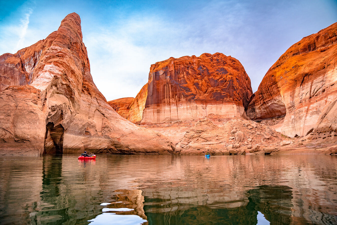
Boaters drift in the calm waters near Gregory Natural Bridge.
EDIT
Again they inflated their rafts and paddled through the widening canyon to the place where Gregory Natural Bridge was said to be rising above the water. The closer they got, the more Retterbush felt anxious, concerned that their travel would be for naught, that snowmelt would have inched the water up, kept the arch below the lake. “We came around a corner, and it was more magnificent than I could have imagined,” Retterbush said. “It was honestly one of the most beautiful parts of canyon country I've ever seen.” A 60-foot section of sandstone bridge had risen from the water, high enough to paddle under. Retterbush and his team piloted their rafts beneath the arch and marveled at its curving underbelly 20 feet overhead. “I've seen tons and tons of arches over the years guiding in the southwest,” Retterbush said. “But I’ve never been that close, underneath this monstrosity. It was almost like flying through.”
EDIT
https://azdailysun.com/news/local/state-and-regional/gregory-natural-bridge-resurfaces-as-long-term-drought-hammers-lake-powell/article_44e0942d-f317-5783-9b8c-d8fae4956501.html

 = new reply since forum marked as read
Highlight:
NoneDon't highlight anything
5 newestHighlight 5 most recent replies
= new reply since forum marked as read
Highlight:
NoneDon't highlight anything
5 newestHighlight 5 most recent replies

Kali
(56,696 posts)that generation, the last to see it are disappearing too.
captain queeg
(11,780 posts)I think it was filled at the end of the 50s. I ran across some documents there about an extensive Native American site that had been discovered up stream. They did what they could to seal and preserve it before it was flooded. If they ever get the water low enough it sounded like it would provide a lot of info. I got the impression that they didn’t really discover it till fairly late and hadn’t been able to explore it much. It is on the Snake River

localroger
(3,782 posts)The Glen Canyon Dam will finally become the impotent monument to hubris that Edward Abbey always knew it was.

hatrack
(64,503 posts)When the diversion gates closed almost 60 years ago, the reservoir had a design capacity of 27 million acre-feet. Today, its maximum capacity is 24.3 million acre-feet. Erosion, like rust, never sleeps and sixty years later 10% of the reservoir's potential capacity is permanently gone. It may be worse than that, but it's been a while since the last full bathymetric survey of sedimentation buildup by USBR.
In the mean time, at full pool, the reservoir on the Colorado River arm once extended to River Mile 68, just downstream of Big Drop 3 in Cataract, about 32 miles upstream from the long-closed marina at Hite. Today that entire section, and another +/- 10 miles downstream from Hite is a river. More to the point, it's a river cutting its way through silt beds, mobilizing sediment and pushing it downstream.
On the San Juan side, it's a bit more pronounced. The San Juan is a substantially smaller river than the Colorado, but it's also steeper and carries more sediment per cfs of water than the master stream. As a result, and with today's drought, about two-thirds of what was that arm of the reservoir is now also a silt bed with a river slicing across it. The delta is now 26 miles up from the main channel, and the (more or less) 35 miles of the reservoir above it are inaccessible now to anything but a canoe or kayak.

FailureToCommunicate
(14,585 posts)

2naSalit
(100,975 posts)I want to reread it.

L. Coyote
(51,134 posts)
TallMike
(161 posts)be still my hart.
L. Coyote
(51,134 posts)For a short while I lived across the street near his Moab home. The rimrock sunsets were great, lots of evening shade. Used a rim notch to erect an equinox marker in the back yard.
Link to tweet
Link to tweet
roamer65
(37,852 posts)2naSalit
(100,975 posts)
Thunderbeast
(3,799 posts)Hayduke has an idea!

Martin Eden
(15,442 posts)I've hiked to many arches, but I've never paddled to one!