Science
Related: About this forumTropical storms and billowing wildfire smoke rage in the same NASA satellite photo
By Chelsea Gohd 3 hours ago
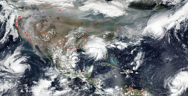
Storms and wildfires rage in the same satellite photo snapped by NASA's Aqua satellite. (Image
credit: NASA Worldview, Earth Observing System Data and Information System. )
A satellite spotted several tropical storms and dozens of wildfires ravaging the United States together in one image.
NASA's Aqua satellite captured six tropical storms and more than 100 different U.S. wildfires in a single photo snapped on Tuesday (Sept. 15). The wildfires, which have particularly scoured California, have now burned about 4 million acres (over 16,000 square kilometers) across 10 states, according to the National Interagency Fire Center. When the photo was taken, there were six named storms total — Sally off the Gulf Coast, Paulette, Rene, Teddy and Vicky in the Atlantic Ocean and Karina in the Pacific.
While "satellite images are generated every single day, in fact multiple times from multiple satellites," NASA said in a statement, "it is still very unusual to capture an image of so many hazards in one image."
In the image, you can see Hurricane Sally making landfall on the Gulf Coast overnight on Sept. 15, where it brought extreme flooding. The red spots in the image show the areas across the country where significantly higher temperatures indicate fires.
More:
https://www.space.com/wildfires-hurricanes-united-states-satellite-image.html

 = new reply since forum marked as read
Highlight:
NoneDon't highlight anything
5 newestHighlight 5 most recent replies
= new reply since forum marked as read
Highlight:
NoneDon't highlight anything
5 newestHighlight 5 most recent replies

RainCaster
(13,455 posts)This is our future. Embrace it, because that is what the GOP wants for you.
The only way out is to vote.

Warpy
(114,505 posts)I just hope that heat dome doesn't come back and send it down over us, it's the first time I've felt relatively human since early July.
The Pacific hurricane season has been suppressed this year, probably by that persistent heat dome over the western US.
People in Oregon have posted that there was early morning thunder and rain, and their air has cleared slightly. Even though the winter storms are likely to bring floods and landslides, I can't remember a year when they've been more necessary.