Science
Related: About this forumA Brand New “Blue Marble” View of Earth
by NANCY ATKINSON
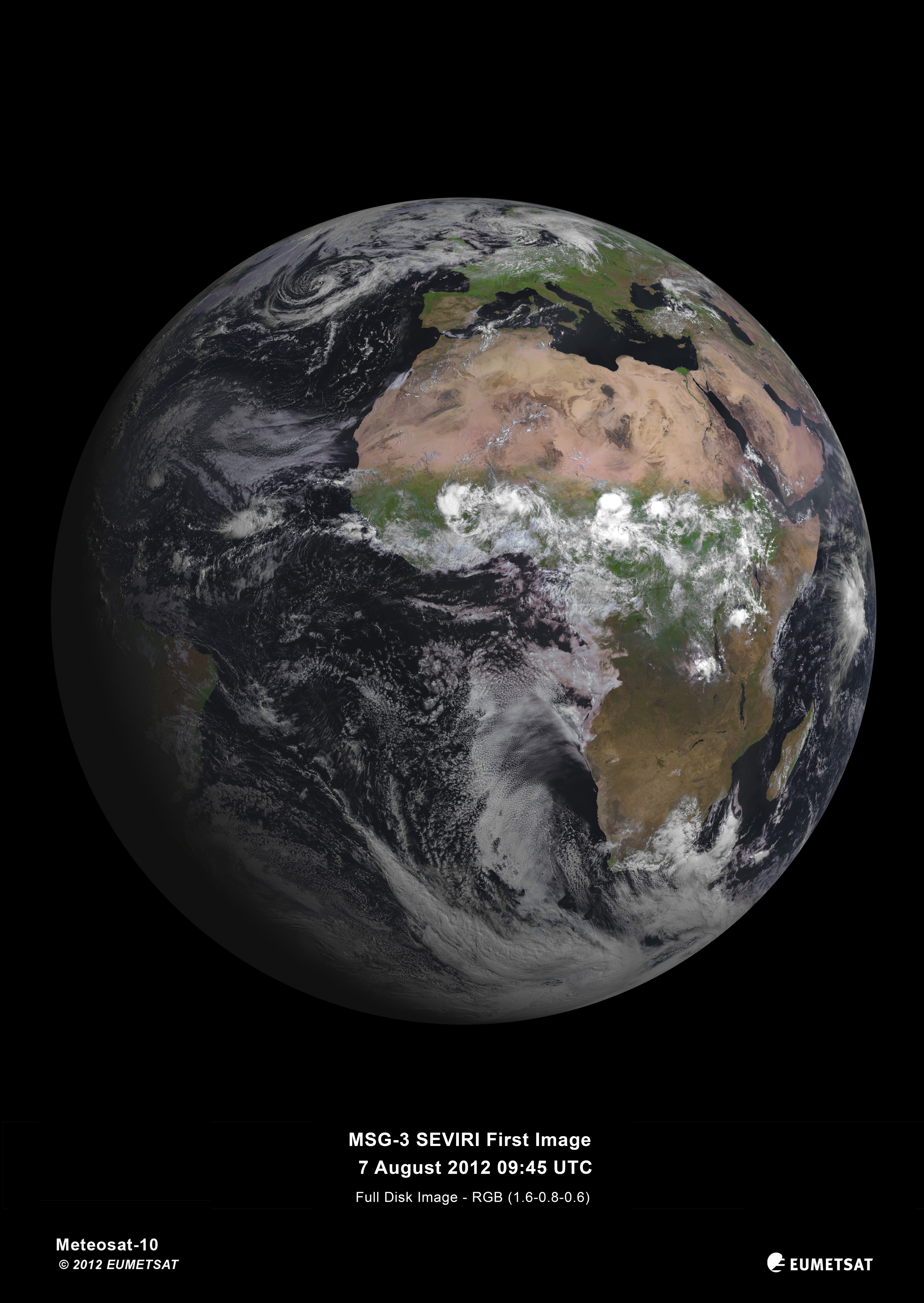
Europe’s latest geostationary weather satellite has captured its first image of Earth, and it’s a beauty! The Spinning Enhanced Visible and Infrared Imager (SEVIRI) instrument on the Meteosat Second Generation-3 (MSG-3) satellite was launched on July 5, 2012, and has since been in the commission stage. ESA says it will still be a couple of months before it is ready for operations.
SEVIRI provides enhanced weather coverage for Europe and Africa in order to improve very short range forecasts, in particular for rapidly developing thunder storms or fog. It scans Earth’s surface and atmosphere every 15 minutes in 12 different wavelengths, to track cloud development. SEVIRI can pick out features as small as a kilometer across in the visible bands, and three kilometers in the infrared.
MSG-3 is the third in a series of four satellites. In addition to its weather-watching mission and collection of climate records, MSG-3 has two secondary payloads.
The Geostationary Earth Radiation Budget sensor measures both the amount of solar energy that is reflected back into space and the infrared energy radiated by the Earth system, to better understand climate processes.
A Search & Rescue transponder will turn the satellite into a relay for distress signals from emergency beacons.
Read more: http://www.universetoday.com/96673/a-brand-new-blue-marble-view-of-earth/
 = new reply since forum marked as read
Highlight:
NoneDon't highlight anything
5 newestHighlight 5 most recent replies
= new reply since forum marked as read
Highlight:
NoneDon't highlight anything
5 newestHighlight 5 most recent replies

valerief
(53,235 posts)
yourout
(8,875 posts)
Odin2005
(53,521 posts)The Sahara is so ugly, a huge swath of desolation on an otherwise green land surface. Hard to believe that just 7,000 years ago it would be green and cloudy at this time of year.

liberal N proud
(61,203 posts)
SirRevolutionary
(579 posts)thanks for sharing n2doc.

GiveMeFreedom
(976 posts)My new desk top image!!
BlueJazz
(25,348 posts)JaneyVee
(19,877 posts)Spitfire of ATJ
(32,723 posts)One of my long time bookmarks:
http://www.goes.noaa.gov/
Full disk
Current Visible
[img]
Current Infrared:
[img] [/img]

midnight
(26,624 posts)Spitfire of ATJ
(32,723 posts)
Politicub
(12,335 posts)
progressoid
(53,387 posts)Cool pic!

Kablooie
(19,121 posts)Posteritatis
(18,807 posts)morningfog
(18,115 posts)
mojowork_n
(2,354 posts)make Greenland look disproportionately large.

tclambert
(11,196 posts)
Rhiannon12866
(258,910 posts)


Kick in to the DU tip jar?
This week we're running a special pop-up mini fund drive. From Monday through Friday we're going ad-free for all registered members, and we're asking you to kick in to the DU tip jar to support the site and keep us financially healthy.
As a bonus, making a contribution will allow you to leave kudos for another DU member, and at the end of the week we'll recognize the DUers who you think make this community great.