General Discussion
Showing Original Post only (View all)Breaking 7.7 quake on Queen Charlotte Islands [View all]
near seattle, on the Canadian side.
Magnitude 7.1 - QUEEN CHARLOTTE ISLANDS REGION
This webpage is being phased out and is no longer maintained. Please use the new Real-time Earthquake Map instead and update your bookmark. See Quick Tips & User Guide.
2012 October 28 03:04:11 UTC
Details
Maps
Tsunami
Earthquake Details
This event has been reviewed by a seismologist.
Magnitude
7.1 (Preliminary magnitude — update expected within 15 minutes)
Date-Time
Sunday, October 28, 2012 at 03:04:11 UTC
Saturday, October 27, 2012 at 08:04:11 PM at epicenter
Location
52.863°N, 131.942°W
Depth
19 km (11.8 miles) set by location program
Region
QUEEN CHARLOTTE ISLANDS REGION
Distances
194 km (120 miles) SW (215°) from Prince Rupert, BC, Canada
253 km (157 miles) S (186°) from Metlakatla, AK
267 km (166 miles) SSE (167°) from Hydaburg, AK
733 km (455 miles) NW (306°) from Vancouver, British Columbia, Canada
Location Uncertainty
Error estimate not available
Parameters
NST= 38, Nph= 38, Dmin=197.8 km, Rmss=1.4 sec, Gp=169°,
M-type="moment" magnitude from initial P wave (tsuboi method) (Mi/Mwp), Version=1
Source
West Coast and Alaska Tsunami Warning Center/NOAA/NWS
Event ID
at00mcl1uw
Did you feel it? Report shaking and damage at your location. You can also view a map displaying accumulated data from your report and others.
Preliminary Earthquake Report
West Coast and Alaska Tsunami Warning Center/NOAA/NWS
http://earthquake.usgs.gov/earthquakes/recenteqsww/Quakes/at00mcl1uw.php
HAS JUST BEEN UPGRADED
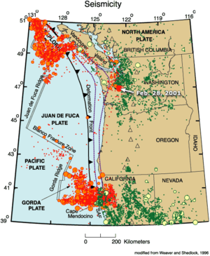
Ok, here is the Juan De Fuca plate
 = new reply since forum marked as read
Highlight:
NoneDon't highlight anything
5 newestHighlight 5 most recent replies
= new reply since forum marked as read
Highlight:
NoneDon't highlight anything
5 newestHighlight 5 most recent replies