Here's why hurricanes are rapidly exploding in strength [View all]
Hurricane Michael’s sudden intensification fits a recent pattern.
The unforgettable thing about record-setting Hurricane Michael will always be how rapidly it became a near-Category 5 storm, perfectly timed for a sneak attack on the Florida Panhandle.
On Tuesday morning, Floridians knew a storm was coming but not how strong it would be. As of 5 a.m., Michael was a strong Category 1 hurricane with a minimum pressure of 973 millibars, a measure of atmospheric pressure indicating that air is rising in the storm, pulling winds toward its center. The official forecast took the storm up to mid-Category 3 at landfall.
But 24 hours later, Michael was already far stronger: It now had 140 mph winds and a pressure falling sharply. The wind speed increased 45 mph in just 24 hours, representing a leap from Category 1 to Category 4 — and the storm wasn’t done intensifying.
Pressure would ultimately fall to 919 millibars, one of the lowest measures of any hurricane at landfall in the United States — and the winds responded by increasing to 155 mph right as the storm struck the coast. This was a borderline Category 5 storm, and it’s clear that the only reason Michael didn’t quite cross that threshold was because it was crossing beaches by that time instead.
This process of “rapid intensification” — extremely dangerous near a coastline — is something we keep seeing lately. Technically, it is defined by the National Hurricane Center as an increase in wind speeds of 35 mph or more in 24 hours.
Read more (Includes video):
https://www.washingtonpost.com/energy-environment/2018/10/11/hyper-hurricanes-warm-waters-fueled-hurricane-michaels-sudden-strengthening-that-fits-recent-pattern/?utm_term=.cf26b78ad0aa
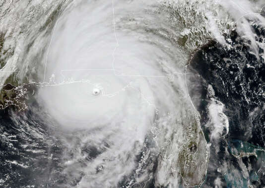 This NOAA/RAMMB satellite image taken on Wednesday afternoon shows Hurricane Michael as it approaches the U.S. Gulf Coast.
 (Lizabeth Menzies/NOAA/RAMMB/AFP)
 = new reply since forum marked as read